
All posts by mike@mikeshaw.tv
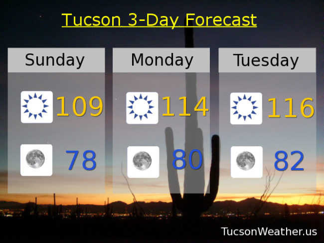
Forecast for Sunday, June 18, 2017
EXCESSIVE HEAT WARNING until Thursday evening at 7:00 so be warned, there will be excessive heat.
Sunny today with a high near 109.
Clear tonight with a low in the upper 70s.
114ish tomorrow. 116 Tuesday. 115 Wednesday. 112 Thursday. 110 Friday. 111 Saturday.
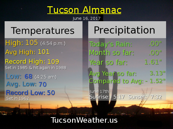
Almanac for Saturday, June 17, 2017

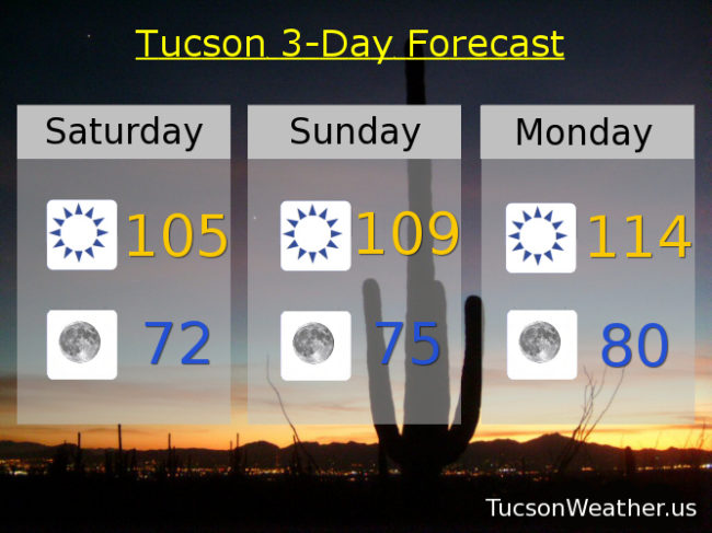
Forecast for Saturday, June 17, 2017
EXCESSIVE HEAT WARNING starts today and repeats through at least Monday. It will be hot but an increase in moisture early next week may actually save us from hitting our all time record high of 117. Stay hydrated lest you burst into flames and be cool!
Sunny today with a high near 105.
Clear tonight with a low in the low 70s.
109ish tomorrow. 114 Monday. 116 Tuesday. 115 Wednesday. 112 Thursday. 110 Friday.
Forecast & Records:
June 17th – Forecast 105, Record 109
June 18th – Forecast 109, Record 113
June 19th – Forecast 114, Record 115
June 20th – Forecast 116, Record 112
June 21st – Forecast 115, Record 112
June 22nd – Forecast 112, Record 114
June 23rd – Forecast 110, Record 113
Almanac for Friday, June 16, 2017
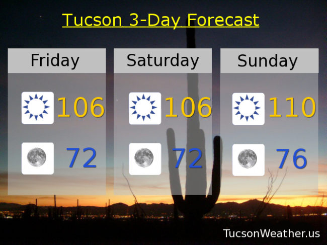
Forecast for Friday, June 16, 2017
It’s Friiidaaay!!! Stay hydrated lest you burst into flames. EXCESSIVE HEAT WARNING in effect for tomorrow, Sunday, Monday, Tuesday, Wednesday AND Thursday. Amazing! Be cool!
Sunny near 106 today and tomorrow with lows in the low 70s. Near 110 Father’s Day. 114 Monday. 115 Tuesday and Wednesday. 112 Thursday.
Forecast & Records:
June 16th – Forecast 106, Record 109
June 17th – Forecast 106, Record 109
June 18th – Forecast 110, Record 113
June 19th – Forecast 114, Record 115
June 20th – Forecast 115, Record 112
June 21st – Forecast 115, Record 112
June 22nd – Forecast 112, Record 114
Almanac for Thursday, June 15, 2017

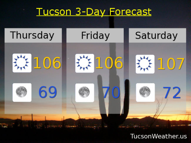
Forecast for Thursday, June 15, 2017
It’s the first day of Monsoon 2017! However. No rain in sight until maybe Tuesday/Wednesday of next week and even then it’ll be a slight chance of storms mainly in the mountains south and east of Tucson. Meanwhile back at the ranch we are at the beginning of a hot streak that will last into next week. EXCESSIVE HEAT WARNINGs have been issued for Saturday, Sunday and Monday for, you know, excessive heat. Be cool!
Sunny today and tomorrow with highs near 106 and lows near 70.
Near 107ish Saturday. 110 Sunday. 114 Monday. 115 Tuesday. 114 Wednesday.
Forecast & Records:
June 16th – Forecast 106, Record 109
June 17th – Forecast 107, Record 109
June 18th – Forecast 110, Record 113
June 19th – Forecast 114, Record 115
June 20th – Forecast 115, Record 112
June 21st – Forecast 114, Record 112
Almanac for Wednesday, June 14, 2017

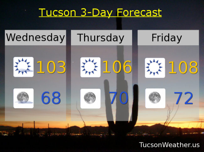
Forecast for Wednesday, June 14, 2017
Just beautiful again this morning! High pressure is starting to move back in and we’ll be back in the triple digits this afternoon. Some high cloudiness possible later today and tonight for possible sunset enhancement. As the center of the high gets closer we will get hotter. EXCESSIVE HEAT WARNING is now in effect for Saturday and will likely be issued for Sunday, Monday, and Tuesday as we get closer. Dad won’t even need charcoal for the grill Sunday! Just hold the steaks in the air for awhile. They’ll cook up just fine. Moisture may be on the increase Monday and Tuesday so we’ll keep an eye whether that will bring a few storms to the weather. Stay tuned!
Sunny today with a high near 103.
Clear tonight with a low in the upper 60s.
Sunny tomorrow with a high near 106. 108ish Friday. 109 Saturday. 110 Father’s Day. 114 Monday and Tuesday.
Forecast & Records:
June 16th – Forecast 108, Record 109
June 17th – Forecast 109, Record 109
June 18th – Forecast 110, Record 113
June 19th – Forecast 114, Record 115
June 20th – Forecast 114, Record 112