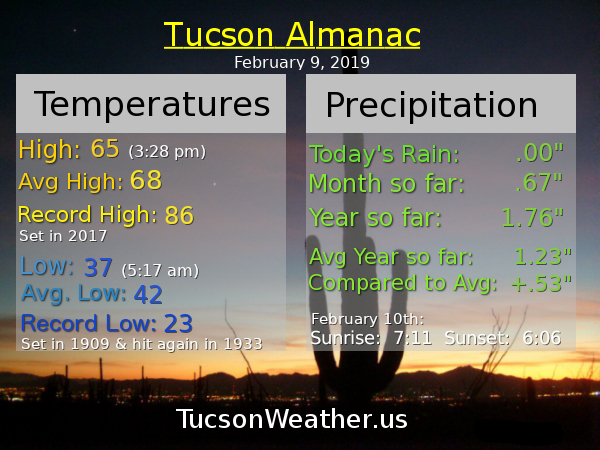
Almanac for Monday, February 11, 2019
Get your red hot cold fronts here! And it’s on its way… ETA any minute now ushering in colder air today and tonight. (that’s what cold fronts do) A few high clouds today, so maybe (maybe) sunset enhancement tonight. Mostly it will be sunny and cooler. Tonight dropping to near freezing. I haven’t decided if I’m bringing in the plants from the deck for some Netflix… Warming back up tomorrow and Wednesday. Our next storm looks to be wet and warm. Snow levels around 8,500 feet! Maybe a quarter to a half inch of rain Wednesday night, Thursday and Thursday night. A cooler system in here by Sunday? Stay tuned!
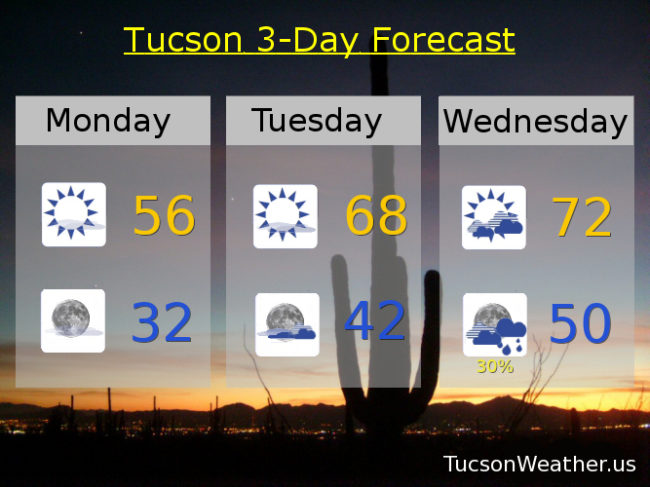
Mostly sunny and cool today with a high in the mid 50s. Clear tonight near freezing. Mostly sunny tomorrow upper 60s. Mostly cloudy Wednesday low 70s. 30% Wednesday night and 50% Thursday upper 60s. 30% Thursday night and 10% Friday near 70ish. Mostly sunny Saturday 70. Upper 60s Sunday. Enjoy!


It’s Friiidaaay!!!
This morning’s low dipped to 32 officially at the airport. It’s freezing! Well, we’ve “climbed” to 33 at the time of this writing (6:40 a.m.), so there’s that. Warmer today with sunshine, but we’ll see an increase in clouds just in time for the weekend. A system missing us well to the north is the culprit. Staying dry for now. Our next rain and high mountain snow possibilities arrive around mid next week. Until then it’s a mix of clouds and sun for possible sunrise and sunset enhancement and temperatures running a few degrees below, to near, average for this time of year. Stay tuned!
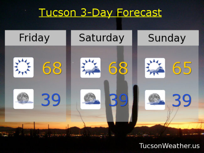
Sunny today with a high in the upper 60s. Mostly clear tonight upper 30s. Partly sunny tomorrow upper 60s. Mid 60s Sunday. Mostly sunny low 60s Monday. Mid 60s Tuesday. Partly sunny low 70s Wednesday. 10% chance for showers Wednesday night and a 30% Thursday. Thursday’s high in the upper 60s.