Category Archives: Daily Forecast

Forecast for Saturday, January 20, 2018

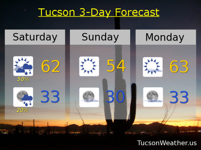
Our storm approacheth! Looks like Plan A is in place. The system moves through this afternoon and evening with scattered showers along and behind the associated cold front that should move through by early afternoon. I don’t want to get our hopes up too much. Still looks like SOME valley locations MAY pick up up to a quarter of an inch of rain. Snow levels will start high but then crash to near 5,000 feet. 1 to 2 inches of snow possible between 5,000 and 7,000 feet with 2 to 5 inches possible above that. Today’s high in the low 60s should occur before the cold front with dropping temperatures this afternoon and evening.

Lingering showers possible until about 8:00 tonight then clearing skies with a FREEZE WATCH in effect from 1:00 a.m. until 9:00 a.m. That means go out and watch it freeze! Also, my plants get to come inside and watch TV.

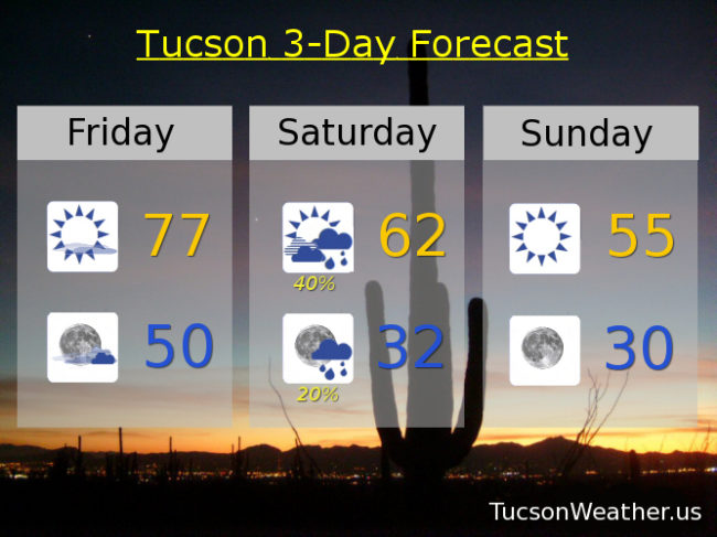
Sunny and cool tomorrow with a high in the mid 50s. FREEZE WATCH again Monday morning from 1:00 a.m. – 9:00 a.m. Please for the love of all that is right and good consider letting the teenagers sleep inside.

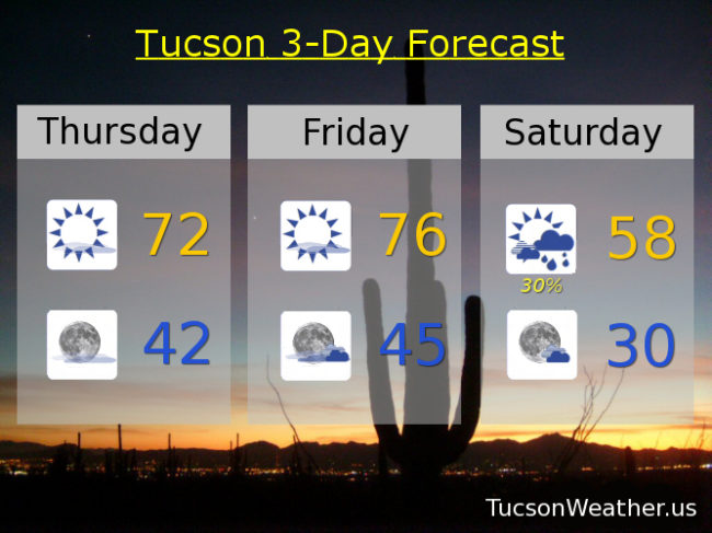
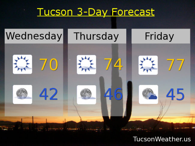
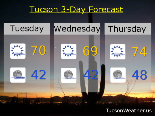
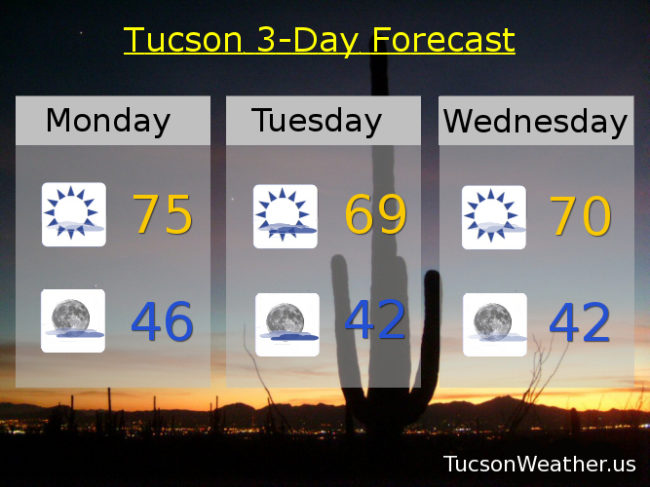
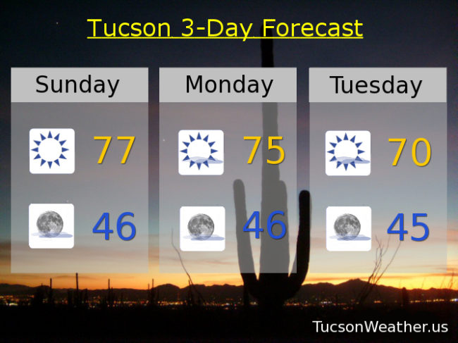
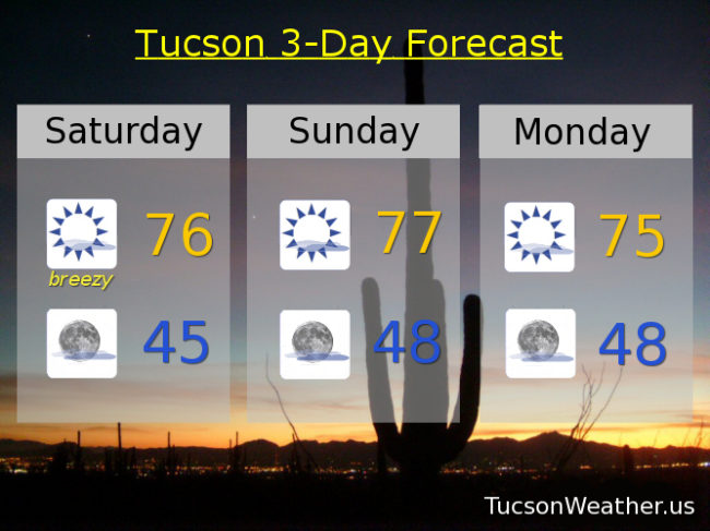
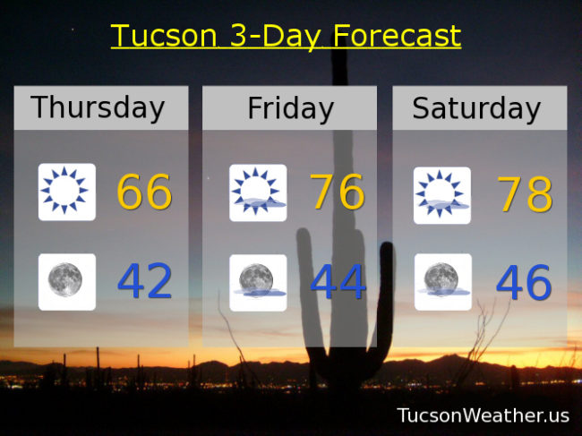
The warm up begins Monday with a high in the low 60s. Upper 60s Tuesday. Low 70s Wednesday and Thursday. Mid 60s Friday. Enjoy!

Forecast for Friday, January 19, 2018

Our storm is running a few hours behind original schedule, but it is on the way even as I type. The big news is we MAY get a bit more rain than first expected! Time will tell. No matter what, big changes are headed our way.

A few high clouds today for possible sunrise and sunset enhancement and a bit warmer than yesterday with a high in the upper 70s.

Partly cloudy tonight with a low near 50ish.

Our storm moves our way tomorrow with the associated cold front due sometime midday/early afternoon. Showers ahead and along the front with up to a quarter of an inch possible in valley locations. Snow levels dropping to around 5,000 feet with about an inch or so possible between 5,000 and 6,000 feet and 2-4 inches above that. High in Tucson in the low 60s early in the day and then falling. WNW winds 10-20 mph and gusty.

Showers hanging around in the evening then clearing skies overnight tomorrow night with a low near freezing.

Sunny Sunday 55. 30 to start the day Monday with a high in the low 60s. Upper 60s Tuesday. Low 70s Wednesday and Thursday. Enjoy!

Forecast for Thursday, January 18, 2018

Warming up a little bit today with a few high clouds headed our way for possible sunset enhancement this evening. Today’s high in the low 70s compared to our average of 65 this time of year.

Mostly clear skies tonight with a low in the low 40s which is only a couple of degrees above average.

Mostly sunny and warmer tomorrow with a high in the mid 70s.

A cold but dry storm system moves through the state this weekend. Breezes picking up on Saturday as the cold front blows through with a chance for scattered showers. Only expecting up to a tenth of an inch of rain for valley locations. Snow levels dropping to near 3,500 feet by Sunday morning, but by then most of the snow will have fallen. Only expecting an inch or so for our local mountains. Saturday’s high in the upper 50s.

The storm exits the state on Sunday leaving cold temperatures in its wake. Low near 30 to start the day Sunday with a high in the mid 50s. Upper 20s Monday morning with a high in the mid 60s.

Warming up next week. Sunny Tuesday upper 60s. Low 70s Wednesday. Enjoy!

Forecast for Wednesday, January 17, 2018

A cool front blew in from the east yesterday afternoon. As a result our afternoon high of 71 occurred at 1:39 in the afternoon before temperatures fell into the mid 60s. A bit of an easterly flow continues today keeping us from warming up too much. Still pleasant though with a high near 70.

Mostly clear tonight with a low in the low 40s.

High pressure nosing back in ahead of our next storm with highs warming into the mid and upper 70s respectively for tomorrow and Friday.

Clouds increase Friday night as our storm approacheth with the system and associated cold front blowing through on Saturday. Not a lot of moisture with this storm, but MUCH cooler. A chance for showers Saturday and Saturday night but those getting rain should only expect up to a tenth of an inch. Snow levels falling to near 4,000 feet! but only an inch or two of snow expected in the mountains. It’ll be chilly (mmm chili) with a high on Saturday in the mid 50s. Low Sunday morning near freezing.

Sunny and cool on Sunday with a high in the upper 50s. Freezing again Monday morning with a high in the mid 60s. Upper 60s Tuesday. Enjoy!

Forecast for Tuesday, January 16, 2018

An Arctic plunge affecting much of the nation east of the Rockies will spill into southeastern Arizona. We won’t be frigid, but a backdoor cold front moving in from New Mexico will cool us off a bit here in the metro and a bit more dramatically to our east. East breezes picking up today 10-20 mph with a high near 70. Still 4 or 5 degrees above average for this time of year. High cloudiness too for sunrise and sunset enhancement possibilities.

Partly cloudy tonight with a low in the low 40s.

Mostly sunny tomorrow with a high near 70. Mid 70s Thursday and Friday.

A storm approacheth Friday night with a slight chance for light rain (half the calories of our regular rain). The storm and associated cold front blows through on Saturday with much cooler temperatures and a chance for showers with a high in the mid 50s! Snow levels dropping to near 4,000 feet. Lingering showers possible Saturday night and then clearing with a low near freezing.

Sunny Sunday upper 50s. Near freezing Monday morning with a high in the upper 60s.

Forecast for Monday, January 15, 2018

Happy MLK Day!

High pressure still in control, but a system missing us to the north tomorrow will kick up our breezes and knock our temperatures down a few degrees. A storm moving through this weekend will gives a major cool down, but as it look snow, not a lot of rain and mountain snow.

Mostly sunny today with a few high clouds for possible sunrise and sunset enhancement and a high in the mid 70s.

Partly cloudy tonight with a low in the mid 40s.

Partly sunny tomorrow with east breezes 10-20 mph gusting to near 30 and a high near 70.

Mostly sunny 70ish Wednesday. low 70s Thursday. Mid 70s Friday.

A cold but somewhat dry storm moves through Friday night into Saturday with a chance for light rain and mountain snow overnight Friday into early Saturday morning. Snow levels could get as low as 3,500 feet!, but not a lot of accumulation. Becoming mostly sunny Saturday with a high in the upper 50s. Near freezing Sunday morning. Sunny Sunday near 60. Stay tuned!

Forecast for Sunday, January 14, 2018

High pressure remains in control. Yesterday’s high of 78 tied the record although the bar was pretty low since January 13th is the only day of the month with a record not in the 80s. Still, it is warm for this time of year. Upper 70s again today.

High clouds from time to time tonight into next week for possible sunrise and sunset enhancement. Mid 70s tomorrow. Near 70 Tuesday and a bit breezy. Low 70s Wednesday and Thursday. Mid 70s Friday.

A storm system moves through Friday night and Saturday. Unfortunately it looks like this storm won’t have a lot of moisture to work with so just a slight chance of rain Friday night. Much cooler Saturday with a high in the upper 50s. Stay tuned!

Forecast for Saturday, January 13, 2018

High pressure is back and our forecast highs are pretty high once again. Our clouds will be high as well. A series of storms missing us to the north will give us a few high clouds from time to time for possible sunrise and sunset enhancement. One such system will kick up our winds this afternoon out of the east 15-25 mph gusting over 30. As those east winds run downhill, the air compresses and warms and we will approach the record high of 78.

Mostly sunny upper 70s tomorrow. Mid 70s for MLK Day. Breezy low 70s Tuesday. Low 70s Wednesday. Mid 70s Thursday. Low 70s Friday. Enjoy!

Forecast for Friday, January 12, 2018

It’s Friiidaaay!

Our persistent area of high pressure that has been providing us with such a mild Winter is baaaaaack. Yesterday was pretty normal by early/mid January standards with a high of 67 after a low of 41 (averages are 65 and 40), but it’s back to the warm stuff today. Mid 70s with sunshine.

A low missing us to the north and east will kick up the winds tomorrow out of the ESE 15-20 mph gusting to near 30. Tomorrow’s high near the record high of 78.

Upper 70s on Sunday too to complete a warm weekend. Mid 70s on MLK Day with sunshine. Another storm missing us to the north will kick up the breezes again on Tuesday mid 70s. Mid 70s Wednesday. Low 70s Thursday.

We are still watching next weekend for the possibility of rain. Right now it looks like the storm will be just a bit too far north for us, but we’ll keep you posted of course.

Forecast for Thursday, January 11, 2018

Happy Friday Eve! It makes the weekend seem closer…

Our storm is no longer ours as it has headed east. We are left with cooler air behind the system today before high pressure builds back in and warms us back up. January 13th is the only day this month that doesn’t have a record of 80 or higher. If the forecast comes exactly true we will tie the record high of 78 on Saturday. Otherwise it’s high clouds from time to time for possible sunrise and sunset enhancement. Highs in the mid 70s Sunday through Wednesday.

Looking past the 7 day forecast to next weekend there is a hint of maybe another storm for a chance of showers and mountain snow. That’s still a long way off so we’ll just have to see how/if it develops. Stay tuned!