Category Archives: Daily Forecast

Forecast for Thursday, November 16, 2017

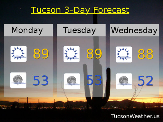
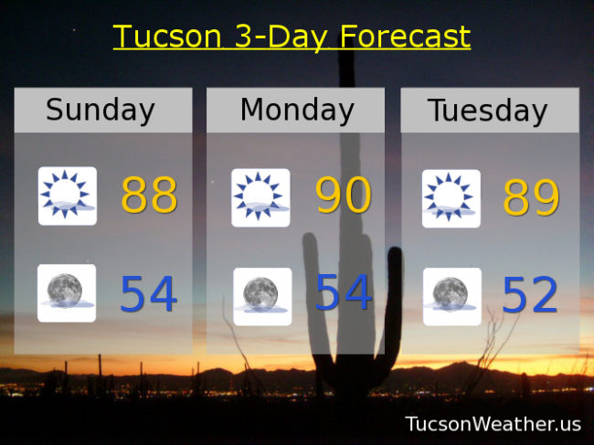
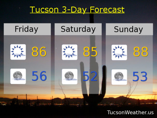
High pressure still in control with near record highs again today. If the forecast come exactly true we will miss the record of 89 set in 1909 and hit again in 1999 by one degree. Then strong storms missing us to our north will cool us off by about ten degrees by Saturday and Sunday morning’s low of 48 will be the first reading in the 40s since May 10th. We’ll warm back up again by Thanksgiving with highs back in the mid 80s! Sorry TEP. I don’t need heat or AC so I’ll keep my money if that’s OK with you.

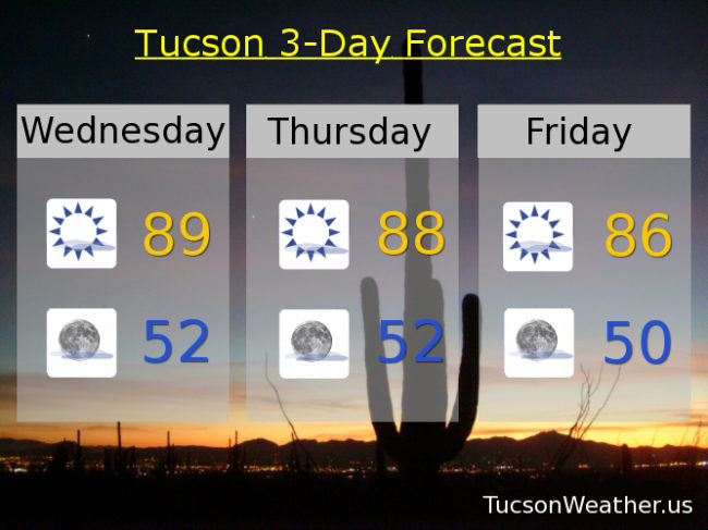
Mostly sunny today with a high near 88ish.

Mostly clear tonight for the Leonid Meteor Shower and a low in the low 50s.

Mostly sunny Friday 84ish. Upper 70s Saturday and Sunday. Near 80 Monday. Low 80s Tuesday. Mid 80s Wednesday.

Forecast for Wednesday, November 15, 2017

We continue to remain under pressure. High pressure centered over NW Mexico is large and in charge over southern Arizona causing our run of near record highs. Yesterday we hit 89 which was 1 short of the record and also the highest high in the United States. Today we do it again. If the forecast high of 89 is realized we will tie the record last hit last year. Sigh. There is some relief in sight. Strong storms affecting the Pacific Northwest will bring us a few degrees of cooling by this weekend, but we will remain well above the seasonal averages. Our average high and low for this time of year are 74 and 46 respectively. High clouds still in the forecast for possible sunrise and sunset enhancement so keep those cameras and smart phones handy!

Mostly sunny today with a high near 89.

Mostly clear tonight with a low near 52.

Upper 80s tomorrow. Mid 80s Friday. Near 80 Saturday. Low 80s Sunday, Monday and Tuesday.

Forecast for Tuesday, November 14, 2017

We tied the record high of 88 yesterday. Congratulations! We should fall just short of today’s record high of 90, but still very warm for mid November. High clouds from time to time for possible sunrise and sunset enhancement continues. A glimmer of hope as we head into the weekend and next week. The storm track to our north gets a little closer for some modest cooling. There are hints in the computer models that we may manage a weak southern system with perhaps even a chance for showers as we get closer to Thanksgiving! Right now it’s just a hint. Of course I’ll keep you posted. Stay tuned!

Mostly sunny today with a high near 88.

Mostly clear skies tonight with a low in the low 50s.

Mostly sunny tomorrow upper 80s. Mid 80s Thursday. Low 80s Friday. Near 80 Saturday. Low 80s Sunday and Monday.

Forecast for Monday, November 13, 2017

Looks like we are gonna party like it’s 1999! If the forecast comes true we will bust today’s record of 88 set in 1990 and hit again in 1999. Tomorrow’s record of 90 may fall as well but the official forecast is a degree cooler. Wednesday’s expected high of 88 is just a degree cooler than the record of 89. A “cooling” trend the rest of the week will stop us from flirting with disaster, but it will stay warm. Mid 80s Thursday. Low 80s Friday and Saturday. Mid 80s Sunday. High clouds for possible sunrise and sunset enhancement, so there’s that!


Forecast for Sunday, November 12, 2017

A bit toasty for this time of year with no rain in sight. The good news is we’ll have high clouds from time to time for possible sunrise and sunset enhancement. Today’s record high of 90 looks to be safe with a high of 88 expected. Tomorrow’s record high of 88 is going down as we should hit 90! Congratulations. Tuesday’s record of 90 is in jeopardy as we’ll be close. Highs not as high as we head into the the middle and end of the week, but still warm for this time of year. Mid 80s Wednesday. Low 80s Thursday. Near 80 Friday. Low 80s Saturday.

Forecast for Saturday, November 11, 2017

Happy Veterans Day! Thank you for your service and sacrifice so that we might be free.

The weather says early October instead of almost mid November, but it is what it is. We have to deal. Although it’s a bit warm in the afternoon for my taste I am not using any heat or AC so take that TEP!

High pressure in Mexico. Storm track well to our north. We have a westerly flow in between with high clouds from time to time for possible sunrise and sunset enhancement. Highs will be high with 90 on Monday exceeding the record of 88 assuming it comes true (it will). All we can do is make the most of it!

Mostly sunny today with a high near 86.

Mostly clear tonight with a low near 54.

Mostly sunny tomorrow upper 80s. Near 90ish Monday. Upper 80s Tuesday. Mid 80s Wednesday and Thursday. Low 80s Friday.

Forecast for Friday, November 10, 2017

It’s Friiidaaay!

The weather pattern will be stuck in neutral for awhile. Storm track to the north and high pressure centered in Mexico puts us in a westerly flow in between. I think it was an ancient philosopher who said, as long as things don’t change they will stay the same. Subtle changes is all with high clouds from time to time for possible sunrise and sunset enhancement. Otherwise highs in the mid to upper 80s through Wednesday and lows in the mid to low 50s. Low 80s on Thursday.

Forecast for Wednesday, November 8, 2017

Rain! Finally some precious rain. Not a lot, but we’ll take what we got. The Tucson International Airport picked up .09″ between 10:00 and midnight last night. I’m sure we received much less here in Oro Valley as it seemed we were on the northern edge of the rain band, but we did pick up some. The system has left our system and we are left with sunshine the rest of the day with a high near 80. Just a few degrees of average. Low tonight in the mid 50s about 6 degrees above average. We will get warmer as we go thanx to high pressure nosing back in with a few high clouds from time to time for possible sunrise and sunset enhancement. Mid 80s Thursday, Friday and Veterans Day. Upper 80s Sunday and Monday. Mid 80s Tuesday. Enjoy!

Forecast for Tuesday, November 7, 2017

Yay! Rain!!! I mean, if the forecast comes true. A system just off the California coast is steadily heading our way with some tropical moisture hitching a ride. Clouds ahead of the system today giving us a mostly cloudy day with perhaps a sprinkle or light rain show. The main even is tonight as the system moves through with a chance for scattered showers. Valley locations could see around a quarter inch of rain. Hey, well take it! Then the storm moves off to the east leaving mostly sunshine, rainbows and unicorns in its wake. Or probably more accurately, sunshine and warmer temperatures. Enjoy!

Mostly cloudy today with a 10% chance for a shower and a high near 80.

Mostly cloudy tonight with scattered rain showers and a low near 55.

Mostly sunny tomorrow near 80. Mid 80s Thursday, Friday and Saturday. Upper 80s Sunday and Monday.