Forecast for Wednesday, April 18, 2018

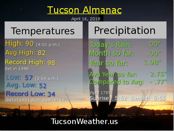
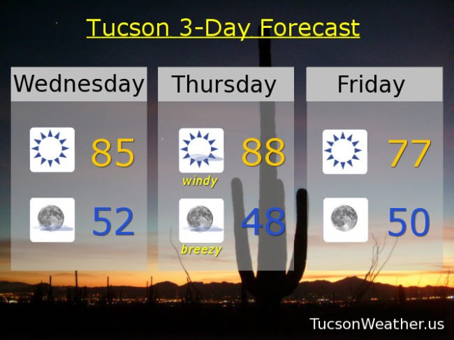
In between systems today, so nice! Just a bit of a west breeze this afternoon, tons of Sun and warmer with a high near 85ish.

Mostly clear skies tonight with a low in the low 50s.

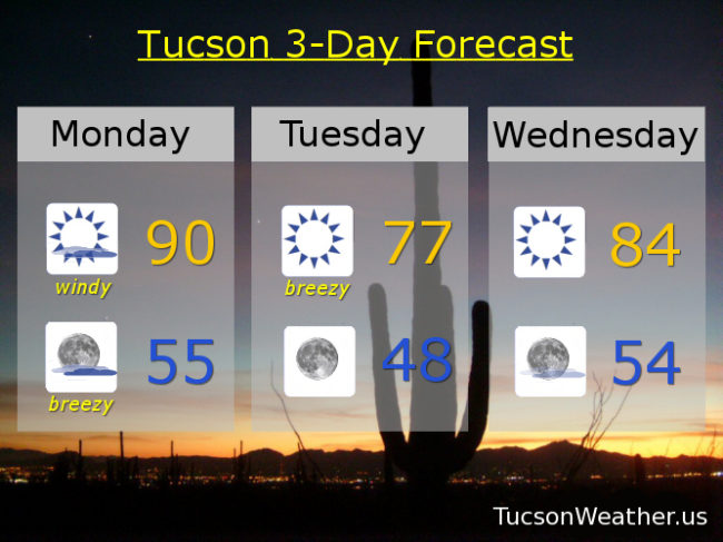
Then there’s tomorrow. Our next strong system will be moving through northern Arizona tomorrow and Friday. You know what’s coming. Not rain! A lot of wind. Areas of blowing dust. Sneezing and wheezing. General human despair basically. The struggle is real! SW winds 20-30 mph gusting to near 40 by afternoon. The National Weather Service has issued a FIRE WEATHER WATCH which is sure to be upgraded to a RED FLAG WARNING. Tomorrow’s high in the upper 80s.

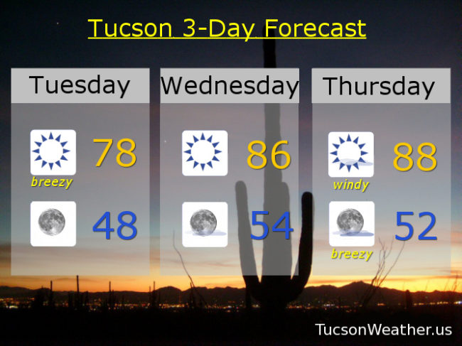
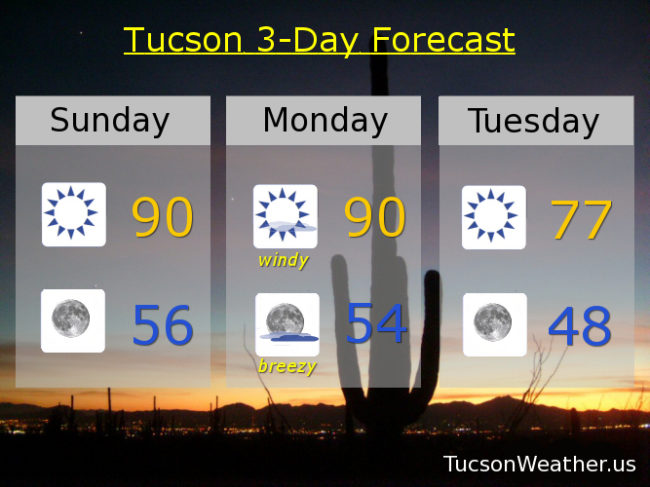
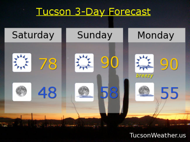
Lingering wind on Friday and cooler with a high in the upper 70s. Sunny Saturday mid 80s. Near 90 Sunday. Low 90s Monday and Tuesday.

Forecast for Tuesday, April 17, 2018

Another breezy day although not quite as bad as yesterday. Still, our exiting system is close enough for west breezes 10-20 mph and gusty. Stronger winds as you head east of town. Since we are so dry the National Weather Service has issued a RED FLAG WARNING from 10:00 this morning until 7:00 tonight. It’ll be cooler too with a high in the upper 70s.

Winds relax tonight with clear skies and a low in the upper 40s.

In between systems tomorrow and warming up into the mid 80s.

A stronger storm will move through northern Arizona on Thursday with strong gusty winds for us (what else is new?!). Expect areas of blowing dust again with this one. The National Weather Service has already issued a FIRE WEATHER WATCH for Thursday. Hopefully there won’t be any fires to watch!

Breezy overnight Thursday with sunshine Friday and cooler behind the storm in the mid 70s. Warming up for the weekend. Mid 80s Saturday. Near 90 Sunday. Low 90s Monday.

Forecast for Monday, April 16, 2018

Another blustery day. Stop me if you’ve heard this one already… A storm missing us to the north will bring gusty winds this afternoon with areas of blowing dust and messed up hairdos. The National Weather Service has issued a RED FLAG WARNING from 10:00 this morning until 7:00 tonight for SW winds 20-30 mph gusting to 40. Not a great day for setting stuff on fire lest you burn the whole thing down. Increasing clouds too (sunset enhancement?) with a high near 90ish.

Breezes persisting tonight decreasing after midnight with a low in the mid 50s.

Sunny and breezy tomorrow with a high in the upper 70s. Warming up between systems Wednesday with a high in the mid 80s. Another windy day Thursday with a high in the mid 80s. Breezy Friday mid 70s. Sunny Saturday low 80s. Upper 80s Sunday. Hang in there!

Forecast for Sunday, April 15, 2018

I have to admit. Yesterday was a bit more breezy than I expected. With the kind of Spring we are having I should have known better. It was still a beautiful day though with a high of 78. We crank up the heat a bit today with sunshine and a high near 90.

Clear skies tonight with a low in the mid 50s.

Our Spring winds return tomorrow with yet another system missing us to the north. The National Weather Service has issued a RED FLAG WARNING for a high fire danger. Please be careful not to set stuff on fire. Areas of blowing dust possible too in the usual blowing dust prone areas. SW winds 15-25 mph gusting to 40 in the afternoon and a high near 90.

Breezy tomorrow night with mostly cloudy skies. Lingering breezes Tuesday with clearing skies. Cooler behind the exiting system with a high in the upper 70s.

Sunny Wednesday mid 80s. Breezy Thursday (what else is new?) mid 80s. Sunny Friday upper 70s. Low 80s Saturday.

Forecast for Saturday, April 14, 2018

Another blustery day yesterday and much cooler as advertised. The peak wind gust at the airport was 36 mph out of the NW and we topped out at 69 degrees. The system responsible for messing up our hair the last couple of days has moved east leaving just a light NNW breeze in it’s wake today. After a chilly start (mmm chili) this morning (43 was our low) we’ll rebound nicely, thank you very much, with a high in the upper 70s to perhaps 80.

Clear skies tonight with a low in the upper 40s.

Mostly sunny tomorrow with a high near 90ish!

Near 90 Monday as well, but another system well to our north will stir up some pollen and dust once again with SW breezes 10-20 mph gusting to 30.

Sunny and cooler Tuesday upper 70s. Mid 80s Wednesday. Upper 80s Thursday. Upper 70s and breezy Friday. Spring!