Forecast for Friday, April 13, 2018

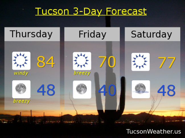
It’s Friiidaaay!!! (the 13th)

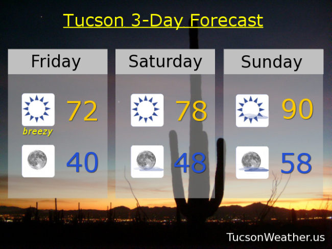
Another breezy day although not as windy as yesterday as our strong storm system exits stage east. Winds have shifted out of the NW as colder air continues to spill into Arizona. Winds should be around 10-25 mph this afternoon gusting to near 35. As a result, the National Weather Service has issued a RED FLAG WARNING for high fire danger. Please, for the love of all that is right and good, if you smoke, keep your butts in the car! You know, and other fire safety stuff. Cooler today with the high in the low 70s. That’s nearly 10 degrees below average for this time of year! Enjoy!

Chilly tonight (mmm chili) as winds relax with clear skies and a low near 40. If we manage to dip into the 30s it will be the first April low in the 30s since 2011.

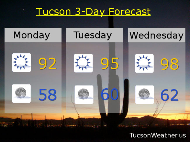
Perfect tomorrow after that cool start! Sunny upper 70s. Near 90ish Sunday. Breezy near 90 Monday. Near 80 Tuesday. Mid 80s Wednesday and Thursday.

Forecast for Thursday, April 12, 2108

If you have hatches you are gonna want to batten them down. Some real deal wind today. In fact, the storm in the Great Basin will give us all the bluster it can muster! The National Weather Service has issued a WIND ADVISORY and a RED FLAG WARNING in effect from 11:00 this morning until 9:00 tonight. Be advised, there will be wind. Areas of blowing dust is no joke today either so please be extra careful in the usual blowing dust areas such as near Picacho Peak and Casa Grande. Sunny and “cooler today with a high near 84ish. The real story is west winds this afternoon 25-35 mph gusting to near 50!!! Yikes!

Breezy tonight as a cold front blows through with winds relaxing somewhat after midnight and a low in the upper 40s.

Much cooler tomorrow with a high near 70. NW winds 15-25 mph gusting to around 35.

A chilly start (mmm chili) Saturday morning with a low near 40. Nice recovery by afternoon with a high in the upper 70s.

Sunny back near 90 Sunday. Partly sunny and breezy Monday upper 80s. Sunny low 80s Tuesday. Mid 80s Wednesday. Must be Spring!


Forecast for Wednesday, April 11, 2018

As you know, we tied the record high of 96 yesterday. Looks like a similar scenario today with the forecast high of 95 the same as the record high set in 1917 and hit again in 1988. Clear skies this morning with a few high clouds this afternoon and evening for possible sunset enhancement. A little bit breezy too as our next storm system approacheth. West winds 10-20 mph gusting to around 25. Be cool!

Get mentally prepared for tomorrow. It’s gonna be fun for all the wrong reasons. The Palo Verde’s are in bloom and with the wind we could see blowing and drifting yellow blooms. Also blowing dust, so there’s that. WIND ADVISORY and RED FLAG WARNING in effect for west winds 20-30 mph gusting to near 45. Brutal. If you smoke, please keep your butt in the car! Tomorrow’s high in the mid 80s.

A cold front blows through tomorrow night keeping us breezy overnight with WNW winds 20-30 mph decreasing after midnight and a low in the upper 40s.

MUCH cooler behind the front Friday with a high near 69ish. Low Saturday morning near 40. IF we dip into the 30s. it will be the first April low in the 30s since 2011!

Nice rebound Saturday afternoon with a high in the upper 70s. Upper 80s Sunday and Monday. Breezy Tuesday low 80s. Spring she is fickle, no?

Forecast for Tuesday, April 10, 2018

For your safety, please keep your arms and legs inside the ride at all times. It’s a roller coaster called Spring! Heeerrre we gooooo!

High pressure large and in charge with near record highs today and tomorrow. Today’s record is 96 and we are expecting 95. Tomorrow’s record is 95 and we are expecting 96 or maybe 97. Breezes picking up just a little tomorrow as our next wind maker approacheth.

That system misses us to the north Thursday but the winds will be whippin’. So much so, plus it’s so dry around these parts, the National weather Service has issued a FIRE WEATHER WATCH. So make sure to go out and watch some fire weather. Also, make sure you don’t start one because that sucker will spread fast if you do! Cooler with a high near 85.

Cold front blows through and the wind keeps going overnight Thursday night/Friday morning. Still breezy, but not as, on Friday and MUCH cooler with a high in the upper 60s to near 70!

Nice weekend ahead. Sunny Saturday 76. 88 Sunday and Monday.

Forecast for Monday, April 9, 2018

High pressure doin’ it’s thang the next few days with record highs possible Tuesday and likely Wednesday. Then it’s wind Thursday and much cooler Friday leading to a beautiful weekend. If you are an allergy sufferer I feel for you. It might get rough with the trees in bloom plus stuff blowing around Thursday. Springtime. A little bit of everything except rain and snow. Here’s your forecast from the all over the road folks at Tucsonweather.us

Sunny and warm today with a high near 92ish.

Clear skies tonight down near 58.

Sunny tomorrow near the record of 96. Sunny Wednesday upper 90s topping the record of 95. Windy Thursday with areas of blowing dust possible upper 80s. Sunny and breezy Friday upper 70s! Sunny low 80s Saturday. Upper 80s Sunday.