Forecast for Saturday, January 27, 2018

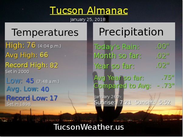
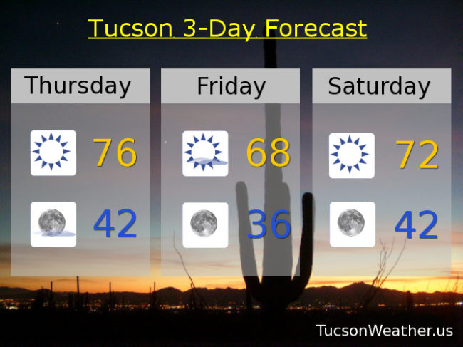
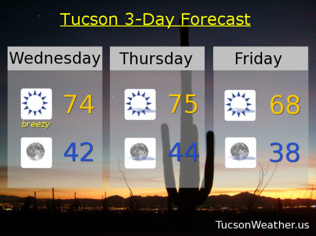
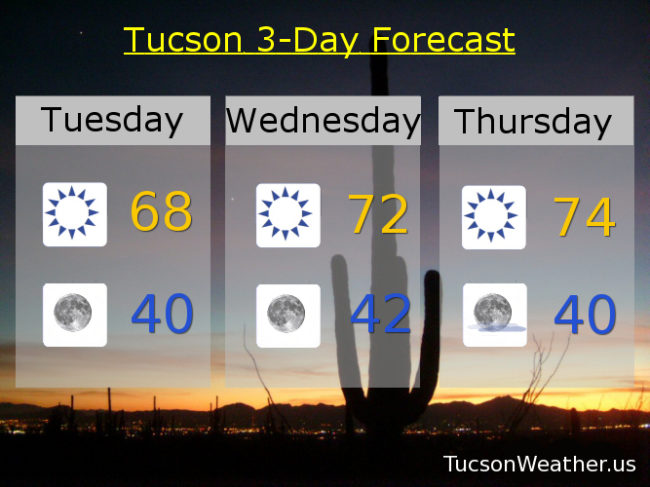
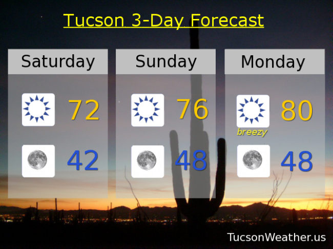
All quiet on the southwestern front. A pretty average day for this time of year yesterday. The high of 67 was 1 degree above average and the low of 39 was 1 degree below. Average those and you get, well, average. Temperatures pushing higher as high pressure noses back into our business. Low 70s today. Mid 70s tomorrow. Gusty east winds Monday will help push our high to near 80. Winds relax on Tuesday with a high in the upper 70s. Upper 70s Wednesday too. Mid 70s Thursday and upper 70s Friday.

The National Weather Service says we are a lock for the warmest January on record. Our persistent pattern is expected to persist into February. Continued warmth for us while the northern, central, eastern and even southern parts of the nation look forward to another arctic outbreak. Yikes! Enjoy not having to shovel sunshine!

Forecast for Friday, January 26, 2018

It’s Friiidaaay!!!

A cool front blowing through southern Arizona today will, well, cool us off. Upper 60s this afternoon with a few high clouds for possible sunrise and sunset enhancement.

Mostly clear tonight with a low in the upper 30s.

Warming up this weekend with a high Saturday in the low 70s. Easterly breezes Sunday and Monday helping to push our highs even higher with upper 70s Sunday and near 80 Monday. Upper 70s Tuesday and Wednesday. Mid 70s Thursday. Enjoy!

Forecast for Thursday, January 25, 2018

Another sunny warm day in our corner of the state. Some say it’s tedious, some think it’s great! Sunshine and mid 70s as high pressure rules. Those buried under a blizzard drool.

A high cloud or two perhaps overnight. Mostly clear skies with a first quarter Moon shining half bright.

A storm well to our north a cooler tomorrow brings. Upper 60s for a Friday the Monday through Friday worker sings!

A warming trend again as the weekend begins. Low 70s Saturday and upper 70s Sunday outside with friends.

Near record warmth on Monday predicted. Near 80 the high with sunshine unrestricted. Upper 70s on Tuesday the anniversary of my birth. Let them eat cake! and ice cream for whatever that’s worth. A few degrees of cooling mid next week. Mid 70s Wednesday continuing our warm streak. Enjoy!

Forecast for Wednesday, January 24, 2018

The warm up continues. A bit of an easterly breeze today especially for easterly breeze favored areas such as midtown, eastern parts of town and the south side. Oro Valley not so much, but still a little breezy in the OV. Call it 10-20 mph and gusty with a high today in the low to mid 70s.

Clear skies tonight with a low in the low 40s.

A few high clouds tomorrow for possible sunrise and sunset enhancement with a high in the mid 70s.

A storm missing us to the north on Friday will knock our temperatures back a few degrees with a high in the upper 60s. Sunny Saturday low 70s. Upper 70s to near 80 Sunday. Upper 70s Monday. Mid 70s Tuesday. Enjoy!

Forecast for Tuesday, January 23, 2018

Freezing again this morning with a low of 30 so far at the airport. An easterly breeze and nuthin’ but Sun will help our high rebound to the upper 60s this afternoon.

Not as cold tonight with clear skies and a low near 40.

High pressure building back in tomorrow and Thursday with highs in the low to mid 70s respectively.

A storm misses us to the north on Friday kicking up a few breezes and knocking our high back into the upper 60s.

The warm up resumes this weekend with highs in the low 70s Saturday. Upper 70s Sunday and Monday. Enjoy!