Forecast for Saturday, December 23, 2017

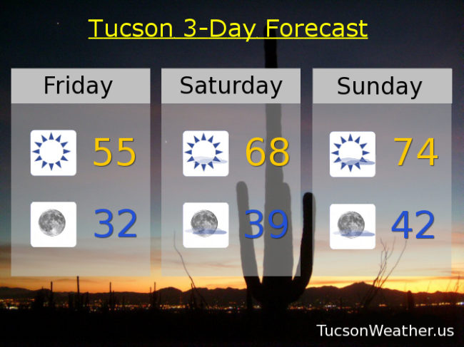
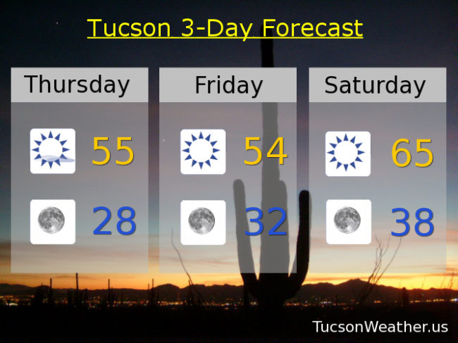
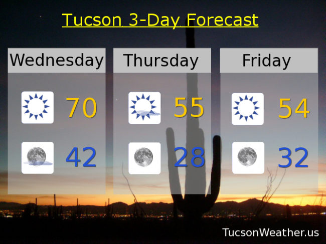
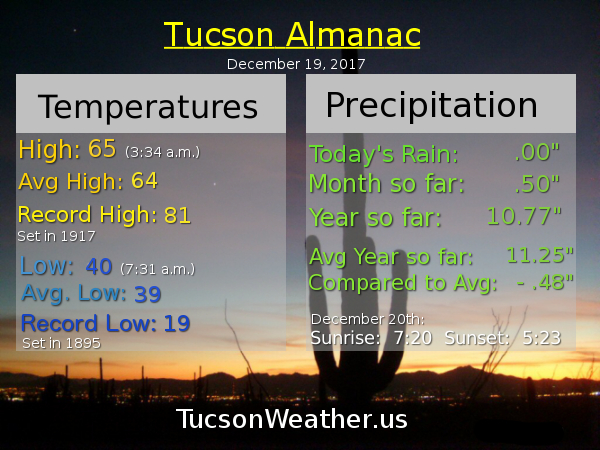
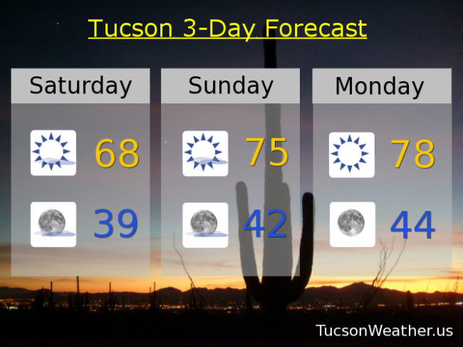
Our warming trend is fixin’ to commence (which is redundantly repetitive, but you get the idea). High pressure nosing back into our business with a few high clouds from time to time for possible sunrise and sunset enhancement. Upper 60s this afternoon. Mid 70s tomorrow. Upper 70s for Christmas. Mid 70s Tuesday, Wednesday, Thursday and Friday. Lows in the upper 30s tomorrow morning then in the low to mid 40s. Enjoy!

Forecast for Friday, December 22, 2017

HARD FREEZE WARNING until 9:00 this morning. It is freezing hard out there right now. My plants are inside the living room enjoying the day. We might watch some football together later. They get to stay in one more night since it’s supposed to dip near freezing again tonight after a cool high of just 55ish. Then it’s a fast warming trend through Christmas into next week. 68 tomorrow. 74 Christmas Eve Day. 76 Christmas Day will be the warmest Christmas since 2005 if it all comes true. Sigh. I guess it will be a tank top Christmas after all. Mid 70s Tuesday too. Then we start to cool off as a new storm approacheth. However it looks like we will stay dry. Hopefully that will change as we get closer. Stay tuned! Low 70s Wednesday. Upper 60s Thursday.

Forecast for Thursday, December 21, 2017

It’s a HARD FREEZE WARNING on the second day of Astronomical Winter. The Winter Solstice arrives at 7:28 this morning as the Sun will appear directly over the Tropic of Capricorn. Meanwhile a cold front is barreling our way scheduled to arrive this afternoon. Breezy conditions today as the front approacheth and subsequently moves through. The colder air behind the front will give us the coldest night of the season so far with a HARD FREEZE WARNING from midnight until 9am. Be warned. It’s gonna freeze. Hard. Please, for the love of all that is right and good, let the teenagers sleep inside tonight. My plants will be watching TV with me the next couple of nights as lows will likely be in the mid to upper 20 by tomorrow morning. Mid 50s today and tomorrow with another chilly night (mmm chili) tomorrow night down near freezing. Warming up this weekend though. Mid 60s Saturday and low 70s Sunday. Mid 70s for Christmas Day after starting the festivities in the low 40s. Mid 70s Tuesday too. Low 70s Wednesday. Enjoy!

Forecast for Wednesday, December 20, 2017

Pretty average day for this time of year yesterday with the high and the low just one degree above average. We hit a high of 65 after a low of 40. A little warmer this afternoon as we anticipate the arrival of some cold air tomorrow. The cold front should arrive just after the Winter Solstice at 7:28 a.m. and continue to blow through during the day as a storm tracks along the Arizona/Utah border. Highs only in the mid 50s and it will feel colder with NW breezes 10-15 mph and gusty. Winds relax tomorrow night and the cold dry air will allow any remaining “heat” to radiate into space (echo: space space space…). Temperatures will fall like something dropped from a high place (perhaps like a rock, for example). A HARD FREEZE WATCH is in effect for Thursday night/Friday morning so be ready to watch a hard freeze. Lows should be in the mid to upper 20s to start the day Friday. Brrrrrr. A cool day again on Friday with a high in the mid 50s and another freezing morning to start the day Saturday. High pressure starts to move back in this weekend with warming temperatures. Sunny Saturday and Sunday mid 60s. Upper 60s Christmas Day. Near 70 Tuesday.

Forecast for Tuesday, December 19, 2017

It’s fixin’ to get cold! But, first things first. Our storm has moved on. It was nice while it lasted, but time changes things. Sometimes saying good bye to one storm means having room in our lives for the next. Not sorry for what we lost but happy that it happened! The next storm is due to arrive in the Four Corners from British Columbia by Thursday. Too far north to bring us rain or snow, but it will bring the cold. Today’s high right at average for this time of year at 64. Tomorrow a bit warmer perhaps as high as 70ish. Then it’s a NW breeze that blows and cold air spills into the state. Mid 50s Thursday and Friday with a couple of cold nights. Upper 20s Friday morning and around freezing to start the day Saturday. Maybe think about letting the teenagers sleep inside? Warming up some this weekend with mid 60s Saturday and near 60 Sunday. Sunny low 60s for Christmas Day.