
Forecast for Tuesday, November 28, 2017
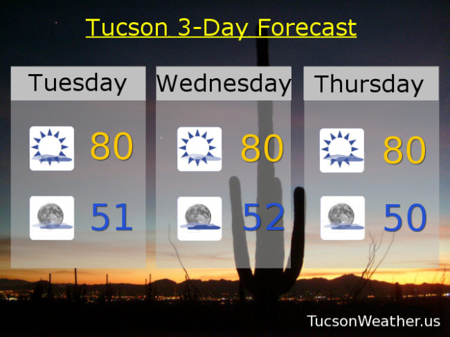
Whew! Glad that’s over! Change is here and change is good. Storm track to our north will continue to move farther south as we go through the week bring a mixture of clouds and sun for possible sunrise and sunset enhancement. Cooler temperatures too. Finally! A slight chance of rain this weekend into next week with temperatures finally near average by Monday. We’ll know more as we get closer. Stay tuned!
Increasing clouds today with a high near 80.
Partly cloudy tonight with a low in the low 50s.
Mostly sunny tomorrow with a high near 80ish. Partly sunny Thursday near 80. Sunny Friday near 80. Mostly sunny Saturday low 80s. Slight chance for showers Sunday mid 70s. Mostly sunny Monday upper 60s!
Forecast for Monday, November 27, 2017
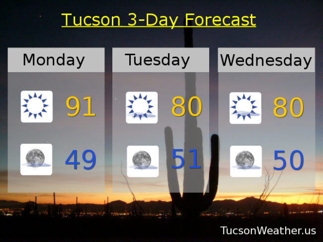
Our hottest Thanksgiving weekend on record has come to a close, but what a finish! 92 yesterday obliterated the old record of 86 set in 1950 and hit again in 1998. It was also the latest day in a calendar year to hit 90 degrees or higher. A record we will likely eclipse today! Even persistent weather patterns change eventually and we have big changes coming. Storms moving into the Great Basin will push our high outta here and we’ll start to cool down. Highs of 80 the next few days is still 10-12 degrees above average, but obviously cooler than low 90s. Then an actual storm heads our way be the end of next weekend for a chance for rain Saturday night into Sunday and highs near 70! It’s a ways off, so we’ll keep an eye on the details as we get closer. Stay tuned!
Sunny today with a record high in the low 90s.
Partly cloudy tonight with a low in the upper 40s to near 50.
Mostly sunny tomorrow with a high near 80ish. Near 80 Wednesday, Thursday and Friday. Mostly sunny Saturday upper 70s. Near 70 Sunday with a chance for rain showers.
Almanac for Sunday, November 26, 2017

Forecast for Sunday, November 26, 2017
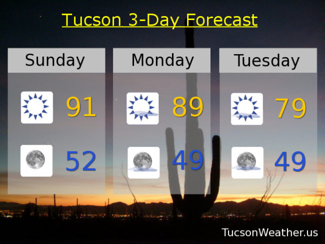
Another record high yesterday with our second 88 degree day in a row. 91 predicted today which will easily best today’s record of 86. The biggest problem I have is the prediction of 91. Just NO! Hashtag #Never90InNovember. Ugh. We’ll see. If we do hit 90+ it will be the latest 90 degree day in Tucson history. Hard to believe our average high for this time of year is 69! Another record tomorrow before we tap the breaks. Storms missing us to the north will cool us off quite a bit, but even 79 is 10 degrees above average! Wow!
Sunny today with a record high near 91ish.
Clear tonight with a low in the low 50s.
Mostly sunny tomorrow near 89. 79 Tuesday and Wednesday. Upper 70s Thursday, Friday and Saturday as well.
Almanac for Saturday, November 25, 2017

Forecast for Saturday, November 25, 2017
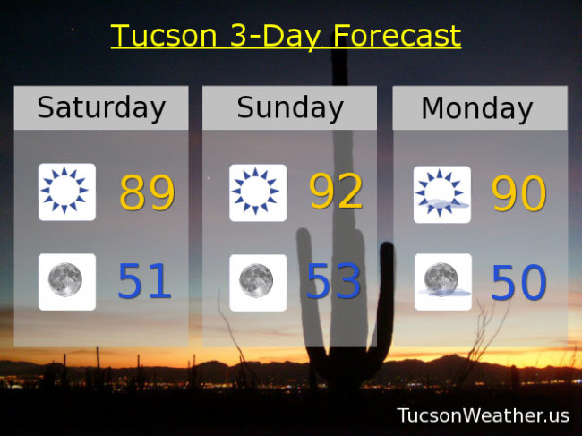
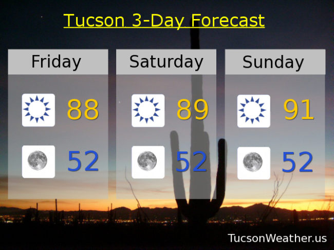
Wow! It’s all coming true. The record Thanksgiving weekend is trucking right along. Our pal high pressure is parked over our heads and there’s not much we can do except marvel at its dominance and enjoy the warmth. Yesterday’s high of 88 was a new record. Today’s record is 86 set 122 years ago. If it falls as expected it will be the oldest record to be broken since records have been kept for 123 years. Tomorrow’s expected high of 92 will easily be the latest occurrence of 90 in our history only to be out done by Monday if our forecasted high of 90 comes true. All records of course. If you prefer actual Fall like temperatures in the Fall, hope is on the horizon. A series of storms missing us to the north will drop our high temperatures into the 70s and lows in the mid to low 40s starting Tuesday and lasting through the rest of the week. MAYBE a chance of rain as we start December. Of course we’ll keep you posted. Stay tuned!
Almanac for Friday, November 24, 2017
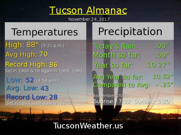
Forecast for Friday, November 24, 2017
So. 89 yesterday. Hottest Thanksgiving evah. New record high for the date. Latest 89 degree day in Tucson’s 123 year history of keeping records. Pretty amazing. And yet to me it didn’t seem that hot. Maybe it’s because my aprtment faces north and it’s a good 10 degrees cooler on the deck during the afternoon. Maybe I’m just used to 80 something in the fall. We’ve sure had a lot of that and it’s going to continue. The hottest Thanksgiving Day Weekend rolls on with another record expected today, tomorrow and Sunday. What kills me about Sunday’s forecast is that dreaded psychological barrier of 90 degrees. Please NO! Otherwise, hey, it is what it is. TEP still ain’t getting my money! Big cool off next week with some breezes Monday and Tuesday as a storm goes through the Great Basin and knocks us back into the 70s!
Sunny today with a high near 88.
Clear tonight with a low in the low 50s.
Upper 80s tomorrow. Near 90 to the low 90s Sunday! Upper 80s Monday. Mid 70s Tuesday. Upper 70s Wednesday. Mid 70s Thursday.
Almanac for Thursday, November 23, 2017
