Forecast for Sunday, October 29, 2017

Another really warm day before a weak storm system currently off the central California coast heads our way. It will sink toward Baja California before it takes a turn tomorrow and tracks along the International Border. As it moves to our south tomorrow night we’ll have a slight chance for light rain and cooler temperatures too. Halloween looks to be the ghoulist, er, I mean coolest, day of the seven day forecast with highs just a couple of degrees above average. After the low departs we’ll have a bit of a warming trend late next week as high pressure noses back into southern Arizona. Mornings remain refreshingly cool!

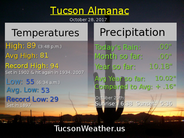
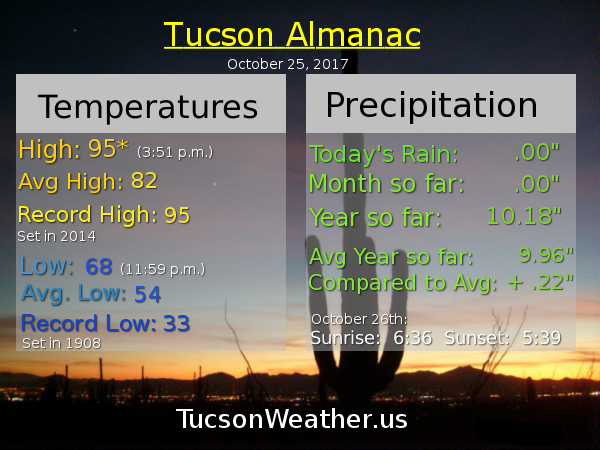
Sunny today with a high near 92.

Clear tonight with a low near 58.

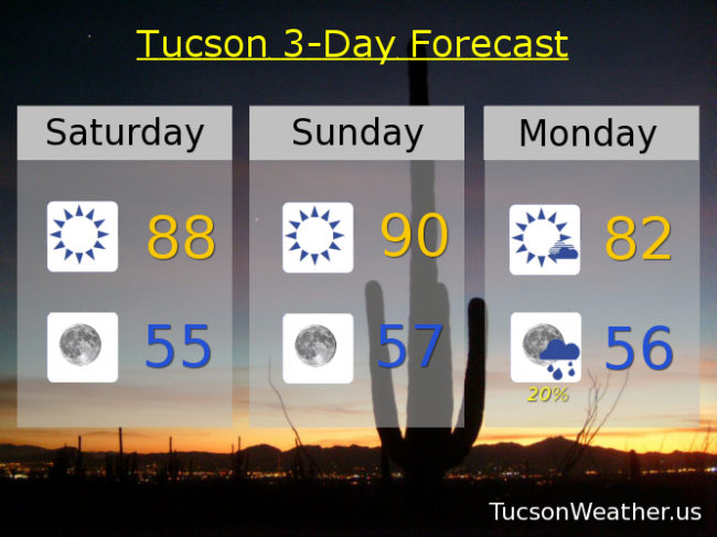
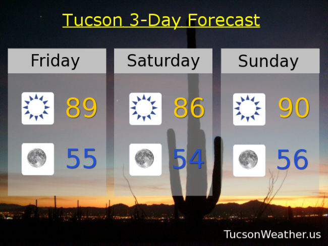
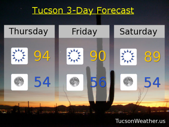
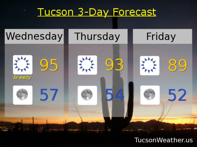
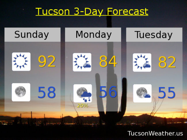
Mostly sunny tomorrow with a high in the mid 80s and a chance for light rain Monday night. Partly cloudy Tuesday low 80s. Sunny low 80s Wednesday. Mid 80s Thursday, Friday and Saturday.

Forecast for Saturday, October 28, 2017

Maybe October won’t tie for the driest month on record after all! Or, maybe it still will, but there is a chance for light rain (half the calories of our regular rain) Monday night. Still warm this weekend, but at least the spell of mid 90s has been broken. Tomorrow will be the last 90 degree day of the year assuming the forecast comes exactly true. Then a weak storm system is forecast to track along the International Border giving us a chance for showers Monday night. Another system may head our way for later in the week. Whether that brings showers to our weather or not, temperatures will finally be where they are supposed to be for this time of year. Enjoy!

Sunny today with a high near 88. Near 90 tomorrow. Partly cloudy Monday with a chance for showers Monday night with a high in the low 80s. Mostly sunny Tuesday low 80s. Sunny Wednesday near 80. Low 80s Thursday and Friday.

Forecast for Friday, October 27, 2017

It’s Friiiidaaaaay!!!

A bit cooler today as high pressure gets pushed a bit more to the west. Cooler air in the Plains is moving westward through New Mexico and will move into eastern areas of southern Arizona today knocking their temperatures down to average for this time of year. We remain above average but a few degrees of cooling today and tomorrow is a welcome relief! Back near 90 Sunday. Then a storm system approacheth. Looks like there may enough moisture east of us for showers Monday night into Tuesday, but for now it looks like we will stay dry in the Metro with just a few more clouds. It will cool us off quite a bit to start the work week! After that the computer models are all over the place, but we have plenty of time to sort that out, and we will, as we get closer. Stay tuned!

Sunny today with a high in the upper 80s to near 90.

Clear tonight with a low in the mid 50s.

Sunny mid 80s tomorrow. Near 90ish Sunday. Upper 80s Monday. Partly cloudy Tuesday low 80s. Sunny near 80 Wednesday. Low 80s Tuesday.

Forecast for Thursday, October 26, 2017


Our high pressure is in slow retreat to the west and our temperatures will slowly retreat as well. Highs still above the low 80s average for this time of year through the weekend. Mornings are refreshingly cool, so there’s that. Then some good news. A low pressure system may move our way just in time for Halloween with a slight chance for showers and highs actually at, our slightly below, average! The models are hinting at it, but rain is not yet in the official forecast. Of course we’ll let you know as we go. Stay tuned!

Sunny today with a high near 94 (the record is 96 set in 2001).

Clear skies tonight with a low near 54.

Sunny near 90 tomorrow and Saturday. Low 90s Sunday. Upper 80s Monday. Low 80s Tuesday and Wednesday!

Forecast for Wednesday, October 25, 2017

High pressure moving off to the west as we go through the week which means slowly falling temperatures into the weekend. This morning’s easterly breezes will also be weakening by this afternoon as the high slides west and weakens. If the forecast high comes exactly true today we will tie the record high of 95 set in 2014. No rain in sight. Looks like we will tie the driest October on record with zero, zip, nada, nothing for the month.

Sunny and breezy today with east winds 15-20 mph and gusty this morning relaxing this afternoon. Today’s high near 95.

Clear tonight with a low in the upper 50s.

Sunny tomorrow near 93ish. Upper 80s to near 90 Friday. Mid 80s Saturday. Near 90 Sunday.  Upper 80s Monday and Tuesday.