
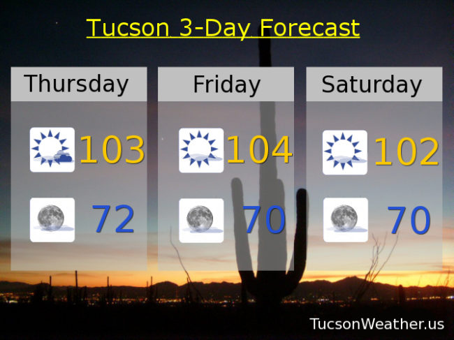
Forecast for Thursday, June 8, 2017
Cicadas don’t lie! I’ve been hearing then for the past 8 days now and sure enough a few showers and storms yesterday afternoon hit mainly south of Davis-Monthan AFB, Corona de Tucson, Vail, Rita Ranch and the far east side of town. I did drive through a few drops on Aviation Parkway as I approached downtown after work and a few more on Oracle around Prince I think. In any event it was nice to see some lightning and rain! We still have some moisture hanging out today. Listen to the Cicadas “singing” again today with a chance for a few storms mainly east of Tucson, but we could pop up one or two in town. Not as hot as our high pressure will be making a slow exit to the east over the next couple of days taking some of the moisture with it. Then a storm moving through the Great Basin will bring some breezes and cooler temperatures Sunday into next week. Monsoon 2017 is getting warmed up! Stay tuned.
Mostly sunny today with a high near 103.
Mostly clear tonight with a low in the low 70s.
Sunny tomorrow near 104ish. 102 Saturday. Breezy upper 90s Sunday. Upper 90s Monday and Tuesday. Near 100 Wednesday.
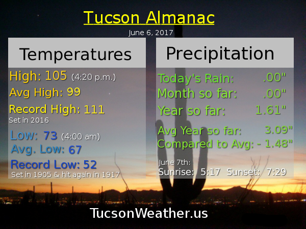
Almanac for Wednesday, June 7, 2017

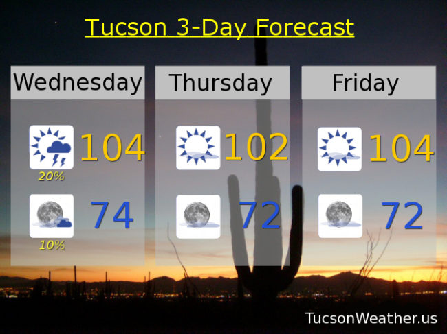
Forecast for Wednesday, June 7, 2017
Moisture increasing today for a chance for afternoon and evening thunderstorms, hopefully near you! Gusty winds possible near showers. Otherwise still kinda hot the next few days. Then our high pressure moves east and a system moving through the Great Basin will kick up our winds and knock down our temperatures below 100. Enjoy!
Mostly sunny today with a chance for afternoon and evening storms and a high near 104.
Partly cloudy tonight with a slight chance for storms before midnight and a low in the mid 70s.
Sunny tomorrow near 102. 104ish Friday. Near 102 Saturday. Breezy Sunday upper 90s. Upper 90s Monday and Tuesday.
Almanac for Tuesday, June 6, 2017
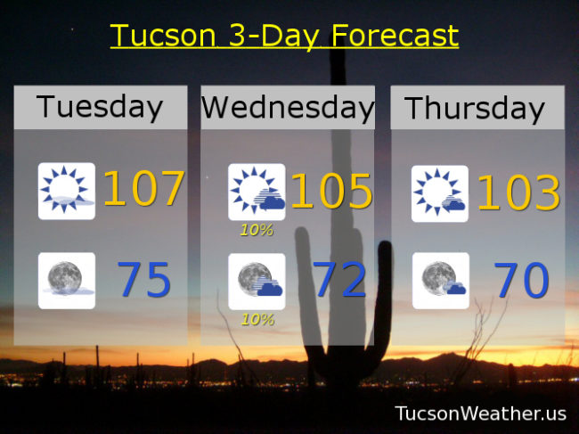
Forecast for Tuesday, June 6, 2017
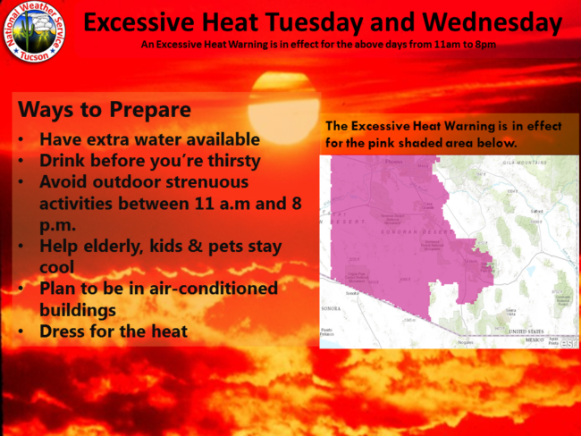
EXCESSIVE HEAT WARNING for today and tomorrow from 11 a.m. until 8 p.m., but wait. Increasing moisture will give us a slight chance for storms tomorrow and MAY keep us from getting as hot as forecast. The National Weather Service MAY decide to drop the warning for tomorrow, but either way, stay hydrated lest you burst into flames. Thursday COULD see a few storms too. Stay tuned to the forecast as we get closer. Breezy and cooler by the end of this weekend as a system misses us to the north and high pressure heads east.
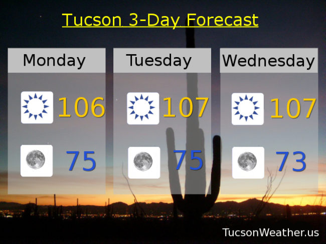
Sunny and hot today with a high near 107.
Clear skies tonight with a low in the mid 70s.
Mostly sunny tomorrow with a slight chance for afternoon and evening storms, hopefully near you, and a high near 105.
Mostly sunny Thursday near 103ish. Near 102 Friday and Saturday. Breezy upper 90s Sunday. Upper 90s Monday.
Almanac for Monday, June 5, 2017

Forecast for Monday, June 5, 2017
Holy Heatwave Batman! This forecast is hotter than blue blazes! Hot enough for the National Weather Service to issue an EXCESSIVE HEAT WARNING for tomorrow from 11am – 8 pm and Wednesday too. Be warned. The heat will be excessive! Today will plenty hot too so take the same precautions. Stay in the AC if you can. Avoid being in the Sun during the heat of the day. Drink lots of water lest you burst into flames. Not much cooling in the forecast until Saturday or so when our high pressure will be moving east and a system will be moving to our north. Until then, be cool.
Sunny today near 106.
Clear skies tonight near 75.
Sunny tomorrow and Wednesday with highs near 107. 106ish Thursday. 104 Friday. Breezy 102 Saturday. Breezy 100 Sunday.
Almanac for Sunday, June 4, 2017

Forecast for Sunday, June 4, 2017
Hot! Stay hydrated lest you burst into flames. Be cool 🙂
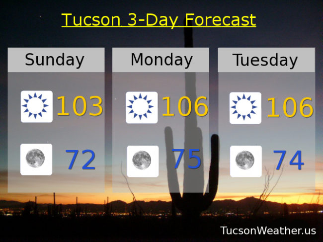
Sunny today with a high near 103.
Clear tonight with a low near 72.
106ish Monday and Tuesday. 107 Wednesday and Thursday. 106 Friday. 102 Saturday.