
Forecast for Sunday, May 14, 2017
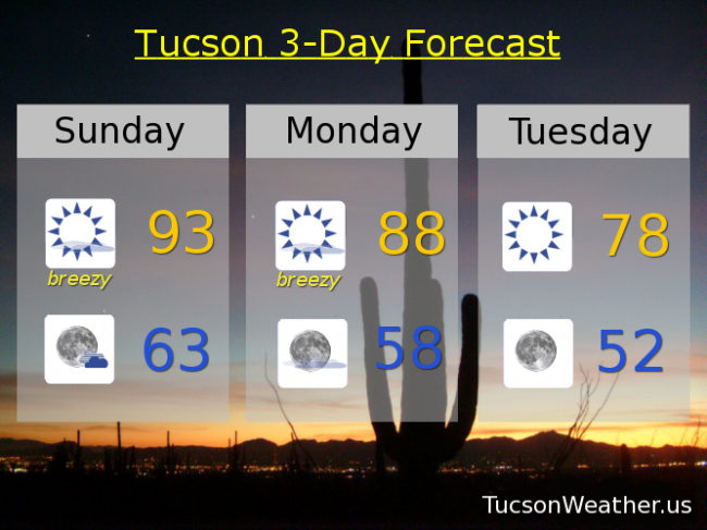
Windy and cooler this week. A series of storms missing us to the north will knock our highs below normal and kick up the winds. So much wind and dry brush that the National Weather Service has issued RED FLAG WARNINGS for today from 11:00 a.m. until 7:00 p.m. and for tomorrow from 11:00 a.m. until 6:00 p.m. Please for the sake of all that is right and good, if you smoke keep your butt in the car. Also be careful lighting stuff on fire. I wonder if the National Weather Service puts out a red flag in front of their office on RED FLAG WARNING days? Things that make you go hmmm. 90s return next weekend.
Mostly sunny and breezy today with SSW winds 15-20 mph gusting to around 30 and a high in the low 90s.
Mostly clear skies tonight with winds relaxing overnight and a low in the low 60s.
Sunny and breezier tomorrow with SW winds 15-25 mph gusting over 35 and a high in the upper 80s.
Sunny Tuesday with just a bit of a breeze and a high in the upper 70s. Breezy Wednesday mid 80s. Sunny mid 80s Thursday. Upper 80s Friday. Low 90s Saturday.
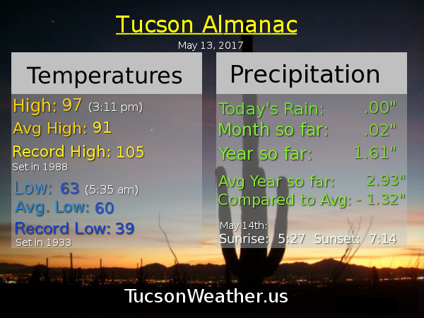
Almanac for Saturday, May 13, 2017
Forecast for Saturday, May 13, 2017
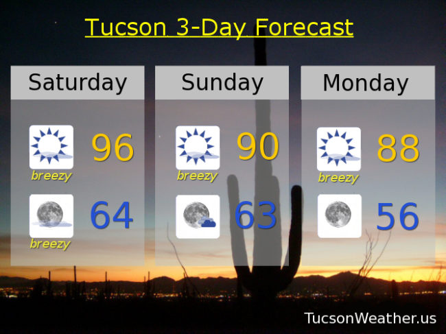
So much wind! Cooling off as we go as well. Still a little toasty today but as a series of storms miss us to the north the winds will be breezy and the temperatures will be easing. Perhaps a few high clouds from time to time for possible sunrise and sunset enhancement. Details:
Sunny today with a SW wind 15-20 mph gusting to near 30 and a high in the mid 90s.
Clear skies tonight with a SW breeze 10-20 mph relaxing overnight with a low in the mid 60s.
Sunny tomorrow with a SW wind 15-25 mph gusting to near 35 and a high near 90.
Breezy on Monday with a high in the upper 80s. Sunny Tuesday low 80s. Breezy Wednesday mid 80s. Mid 80s Thursday. Upper 80s Friday.
Almanac for Friday, May 12, 2017

Forecast for Friday, May 12, 2017
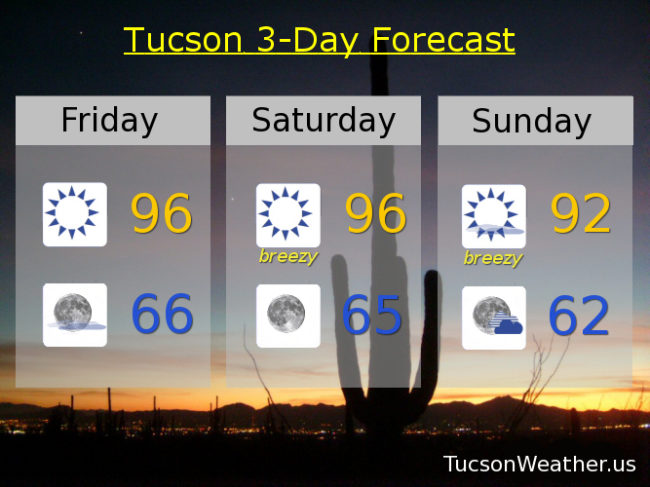
Enjoy the heat while you can. A series of storms missing us to the north will bring periods of wind and somewhat cooler weather. Unsettling for those who don’t prefer unsettled Tucson Weather. No rain in sight. Stay tuned!
Sunny today with a high near 96.
Clear tonight with a low in the mid 60s.
Breezy tomorrow with SW winds 10-20 mph gusting to near 30 and a high in the mid 90s.
Breezy Sunday with SSW winds 15- 25 mph gusting to near 35 and a high in the low 90s.
Breezy Monday mid 80s. Sunny Tuesday mid 80s. Breezy Wednesday mid 80s. Low 80s Thursday.
Almanac for Thursday, May 11, 2017

Forecast for Thursday, May 11, 2017
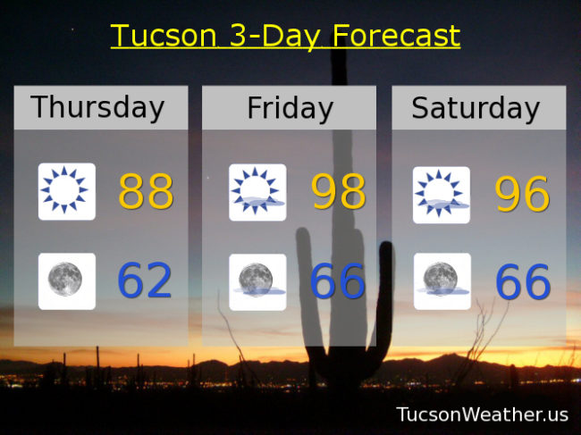
Lovers of the heat rejoice for your time is at hand! Suns out, buns out, as the smell of coconut returns to area pools. Lizards and snakes will find their favorite rock upon which to bake. But alas, a storm system missing us to the north on Sunday will kick up the breezes once again. Temperatures will drop, but not too much. Double alas! Another storm missing us to the north by mid week will kick up the winds again and keep our temperatures from returning to the 90s. Stay tuned.
Sunny today with a high near 88.
Clear skies tonight with a low in the low 60s.
Sunny tomorrow upper 90s. Mid 90s Saturday. Breezy Sunday low 90s. Breezy Monday upper 80s. Mid 80s Tuesday. Breezy upper 80s Wednesday.
Almanac for Wednesday, May 10, 2017

Forecast for Wednesday, May 10, 2017
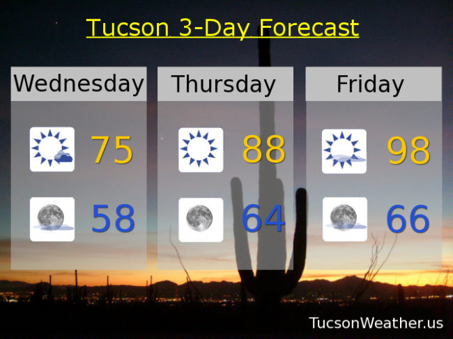
68 yesterday with showers and some snow in the mountains. Crazy awesome for May! Don’t get used to it. The storm is leaving us this morning and then, “let the warming trend begin!” Upper 90s by Friday. A storm misses us to the north Sunday for some breezes and slightly cooler weather, but it’ll still be warm. Here you go:
Mostly sunny today with a high near 75.
Mostly clear tonight with a low in the upper 50s.
Sunny 88 tomorrow. Upper 90s Friday and Saturday. Breezy Sunday mid 90s. Near 90 Monday. Low 90s Tuesday.