Tag Archives: Daily Forecast

Forecast for Tuesday, May 26, 2020

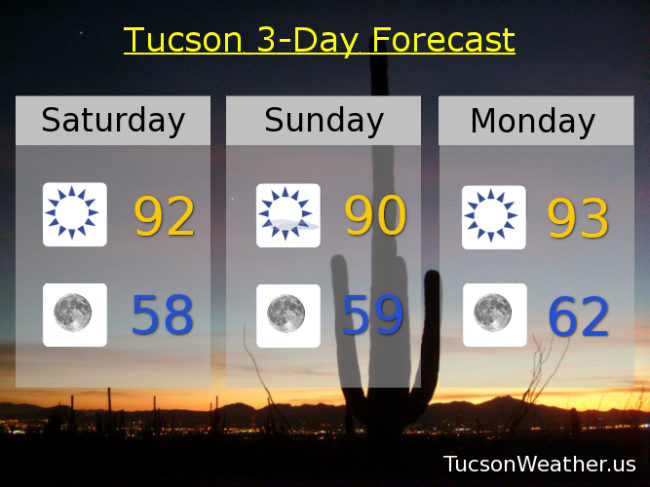
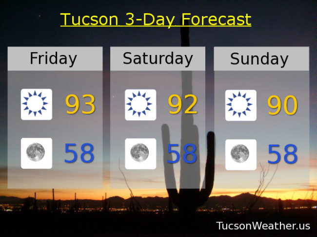
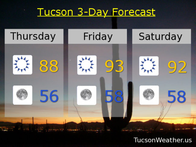
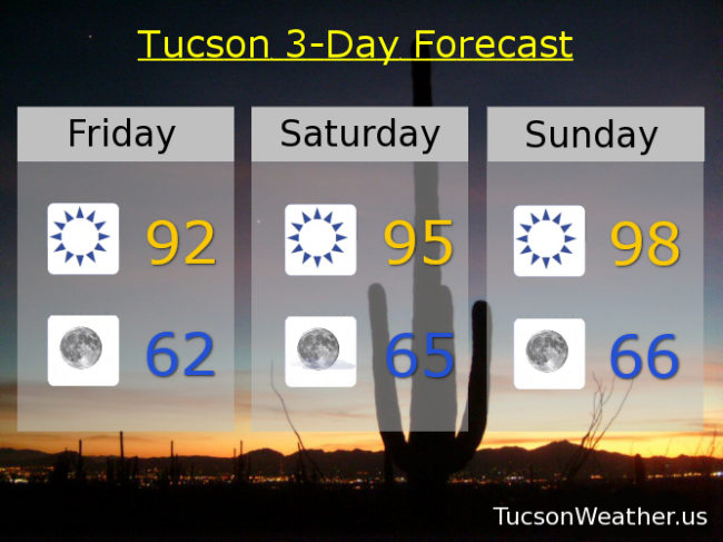
Heat so excessive the National Weather Service has expanded the EXCESSIVE HEAT WATCH from Thursday now through Saturday. Watch out! The heat will be rather excessive. Comfortable in the morning though. One of the benefits of a dry heat.

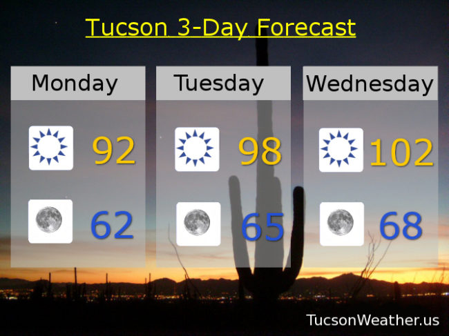
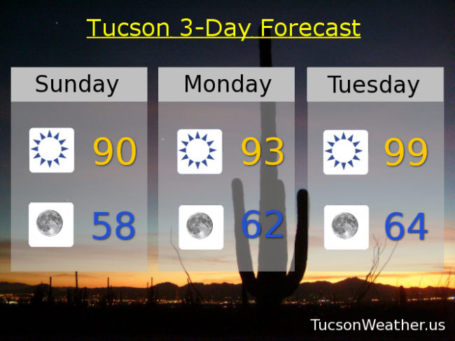
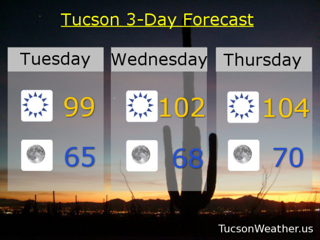
99 (I’ve been waiting so long) this afternoon with nuttin’ but Sun. Mid 60s tomorrow morning. 102 para tu manana. 104 Thursday. 106 Friday. 105 Saturday. 104 Sunday. 101 Monday. Be Cool!

Forecast for Monday, May 25, 2020

Happy Memorial Day! We will never forget the sacrifices that paid for our freedoms…

One more “cool” day before the heat returns. Low 90s today and a light WNW breezy. Low 60s tonight. Upper 90s tomorrow. 102 para tu Wednesday. EXCESSIVE HEAT WATCH Thursday and Friday. Watch out. The heat will be excessive. 105 Thursday. 107 Friday! (ouch) 104 Saturday and Sunday. Enjoy!

Forecast for Sunday, May 24, 2020

90 yesterday. 90ish today! Even more fun is a low yesterday morning of 56! Enjoy it while you can because the heat is returning next week right on schedule. After all, Memorial Day is the traditional start to Summer. The forecast unmasked in 3… 2…

Sunny and relatively cool for this time of year today with a high near 90ish. Clear skies tonight upper 50s. Low 90s Memorial Day Monday. 99 (I’ve been waiting so long) Tuesday. 103 Wednesday. EXCESSIVE HEAT WATCH Thursday and Friday, so go out and watch the excessive heat (um, no) 105 and 106 respectively. 104 Saturday. Be cool!

Forecast for Saturday, May 23, 2020

We now join our amazing weekend already in progress…

93 yesterday is just 1 degree below average for this time of year. Today we’ll drop it another degree (if the forecast comes exactly true) but we will add mph’s to the wind speed. WSW winds 10-20 gusting to 30 this afternoon low 90s. Winds relax overnight tonight with a low in the upper 50s. Near 90ish tomorrow! Low 90s Memorial Day.

Then we turn up the heat. Typical as we appraocheth June. Bring to a boil and let simmer for summer. Upper 90s Tuesday. 103 Wednesday. 105 Thursday and Friday. Enjoy!

Forecast for Friday, May 22, 2020

It’s Friiidaaay!!!

A long weekend for some. For some others the weekend has been going since March, but I digress… The Memorial Day Weekend is looking good as we launch into Summer. We’ll be feeling the heat soon enough so enjoy the relatively average highs and cooler than average lows! Upper 50s in the morning? Yes please and Thank You!

Sunny today low 90s. Upper 50s by tomorrow morning! Breezy fo Sneezy tomorrow with SW winds 15-20 mph gusting to 30 and a high in the low 90s. Sunday looks nice near 90ish. Sunny Monday low 90s. Upper 90s Tuesday. 101 Wednesday. 104 Thursday. Enjoy!

Forecast for Thursday, May 21, 2020

Happy Friday Eve! (makes the long weekend seem closer)

Ahhhhhh. Refreshingly cool this morning in the 50s! How nostalgic! (think Happy Days) A stupendous day today with sunshine and still in the 80s. (OK, we MIGHT hit 90. Maybe) 50s again tomorrow morning.

A really nice Memorial Day Weekend coming up. Low 90s Friday and Saturday, but the winds will be kickin’ up Saturday. Near 90ish on Sunday! Mid 90s Monday.

The heat starts creepin’ in next week. 99 (I’ve been waiting so long) Tuesday. 102 Wednesday. Enjoy!

Forecast for Wednesday, May 20, 2020

Mike Mike Mike Mike Mike. What day is it Mike? Today is the coolest…

It’s good to be part of the cool kids. Mid 80s in late May? Yes please! Even better? Near 50ish to start the day tomorrow! Is this Iowa or Tucson? It’s Tucson. Iowa doesn’t have cool mountains, Gila Monsters, or amazing sunsets. (well, maybe sometimes) Take full advantage because the heat will be coming back next week. (of course it will) Near 90ish tomorrow. Mid 90s Friday. Low 90s Saturday and Sunday. Upper 90s for Memorial Day. 102 para tu on Tuesday. Enjoy!

Forecast for Tuesday, May 19, 2020

I have good news and I have bad news. First the bad news. Breezy fo Sneezy today as a system approacheth. Some might even call SW winds 15-20 mph gusting over 30 windy 🙂 The good news is the system will drop our temperatures quite a bit! Low 90s today. Mid 50s tonight. Mid 80s tomorrow! and low 50s tomorrow night!!! Thursday looks nice too with a high in the upper 80s.

Then we start to warm up. Low 90s Friday, Saturday, and Sunday. (not bad) Upper 90s Monday. Word on the street is next will be hot. Stay tuned!

Forecast for Monday, May 18, 2020

It’s just another Manic Monday. I wish it was… Wednesday! I mean just look it. Mid 80s coming up! Amazing for mid May. But first…

Sunny today and not quite as warm as yesterday’s 98. Still. Mid 90s and breezy fo sneezy. SW winds 10-20 mph gusting to near 30. Winds relax tonight with a low in the low 60s by mornin’, Sunny low 90s tomorrow. Mid 80s Wednesday! Near 90ish Thursday. Low 90s Friday and Saturday. Near 90ish Sunday. Enjoy!

Forecast for Friday, May 15, 2020

It’s Friiidaaay!!! And we are warming up for the weekend. Still. Not bad compared to the beginning of the month.

Sunny today and very close to the average of 91. Not a lot of wind either. Just nice. Average low is 60ish and we’ll be just a couple degrees above that tonight. Sunny mid 90s tomorrow. Upper 90s Sunday. Near 100ish Monday. Mid 90s and breezy fo sneezy Tuesday. Upper 80s Wednesday! Low 90s Thursday. Enjoy!