Tag Archives: Excessive Heat Warning

Forecast for Friday, June 22, 2018

The Sun kissed the Tropic of Cancer yesterday
Did the Moon blush? or did Venus look away?

Today’s high of 108 expected
Summer heat that is just a bit excessive

“Cooling” off this weekend then heating up next week
Waiting for Monsoon rains of which I hear people speak

Sunny today with an EXCESSIVE HEAT WARNING, so be warned, the heat will be excessive. High near 108.

Clear tonight with a low in the mid 70s.

Sunny tomorrow 102ish. Upper 90s and breezy Sunday. 101 Monday. 104 Tuesday. 106 Wednesday. 104 Thursday.

Forecast for Thursday, June 21, 2018

102 yesterday afternoon was exactly average for this time of year. That after a morning low of 68 which is 3 degrees below average for this time of year. Not bad for a June 20th! Refreshingly cool again this morning for coffee on the deck, but here comes the hot stuff. High pressure building in today and tomorrow with tomorrow’s expected high of 108 hot enough for the National Weather Service to issue an EXCESSIVE HEAT WARNING, so be warned, tomorrow’s gonna be hot. A couple of systems missing us well to the north will bring us some cooling this weekend and gusty winds especially Sunday. Then heating back up by mid week. Be cool!

Sunny today with a high near 106.

Clear tonight with a low in the mid 70s.

108ish tomorrow. 102 Saturday. Breezy Sunday upper 90s. 101 Monday. 104 Tuesday. 106 Wednesday.

Forecast for Wednesday, June 13, 2018

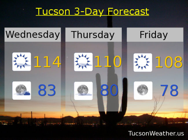
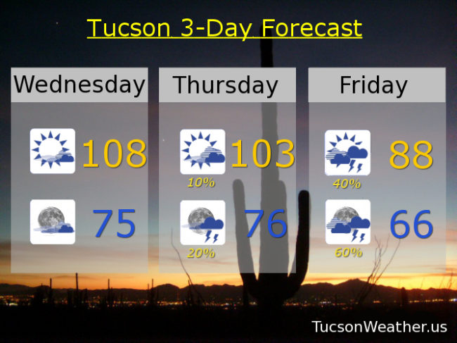
High pressure centered in New Mexico. Close enough for a hot day in Tucson and hot enough for an EXCESSIVE HEAT WARNING. Be warned, there will be excessive heat. Some mid and high clouds around will likely save us from the pain of hitting the record of 110, so there’s that. Also, enough moisture moving in for a slight chance of a storm or two in the mountains.

Call it partly cloudy tonight and warm as moisture from the south continues to increase. That’ll keep the low not so low in the mid 70s.

Deeper moisture moving in tomorrow. A slight chance for storms in the afternoon and a bit better chance for storms in the evening with a high near 103ish. Storms that do form could have gusty winds and blowing dust.

Even deeper moisture moving in on Friday from the remnants of what was once Hurricane Bud. Friday’s forecast is still kind of tricky. Will the clouds move in too early for a cloudy, humid, day with no real trigger for storms to form? Or will there be enough sunshine in the morning to give us a good chance for storms and locally heavy rainfall. Right now the official forecast is for the latter. Let’s hope so. We need it! Either way a high only in the upper 80s!

Good chance for storms continues Saturday with a high in the upper 80s. Drying out Sunday low 90s. Upper 90s Monday. Near 100 Tuesday. Viva Monsoon 2018!

Forecast for Friday, July 7, 2017

The Monsoon is coming!  The Monsoon is coming!  Increasing moisture will lead to scattered storms across the area starting this weekend and continuing into next week.  We are so ready!  High pressure still large and in charge today with an EXCESSIVE HEAT WARNING in effect until 7:00 p.m. so be warned, the heat will be excessive.  Did I mention scattered storms in the forecast starting this weekend?!

Sunny and hot today with a high near the record of 110.

A storm or two possible this evening, hopefully near you, and a low in the low 80s.

Partly cloudy tomorrow with a slight chance of a storm and a high near 107.  Scattered storms possible tomorrow evening into next week.  104ish Sunday.  Near 102 Monday, Tuesday, Wednesday and Thursday.

Forecast for Thursday, July 6, 2017

An EXCESSIVE HEAT WARNING is in effect from Noon today until 7:00 tomorrow night.  Be warned, the heat will be excessive.  Today’s record high is 109 and tomorrow’s is 110 so we’ll be in the ball park.  Thankfully we should see more moisture and a “cooling” trend starting this weekend.  Outflow from storms in Sonora, Mexico will give us that aforementioned more moisture to work with and maybe an actual start to Monsoon 2017!  Stay tuned.

Mostly sunny and hot today with a high near 110.

Partly cloudy tonight with a low near 80.

Near 110 tomorrow with a chance for evening storms.  Chance for storms Saturday through Wednesday with highs near 105, 103, 104, 104 and 102 respectively.

Forecast for Sunday, June 25, 2017

Outflow winds from storms to our east have brought us clouds and moisture to start the day.  As a result we are off to a warmer than the last few days start to the day.  Thanx to the moisture increase we are looking at isolated to scattered storms this afternoon and evening!  Expect gusty winds near storms but a few folks will also get a nice shower, hopefully near you.  Today is also our last day of the EXCESSIVE HEAT WARNING that has been in effect all week.  Tedious and buh bye.  Moisture lingers into tomorrow and then our epic high pressure retreats south as a couple of systems move through the Great Basin.  That will put us in a dry westerly flow drying us out some most of this week and also “cooling” us to near normal highs for this time of year.  Tropical Storm Dora will move to near the tip of the Baja Peninsula.  That moisture will move into Mexico priming the pump for the start of Monsoon 2017 for reals!  Stay tuned!

Partly cloudy today with a chance for afternoon storms and a high near 111.

Partly cloudy tonight with scattered storms before midnight and a low near 80.

Mostly sunny tomorrow with isolated afternoon storms and a high near 107.  Sunny near 107 Tuesday.  104 Wednesday.  103 Thursday.  105 Friday.  Chance for storms Saturday 106.

Forecast for Saturday, June 24, 2017

Today’s record is 113 and we’ll be close!  Drier air has moved in with high pressure restrengthening over our heads means another hot day.  EXCESSIVE HEAT WARNING fixin’ to come to and end tomorrow night and good riddance!  Moisture on the increase tomorrow into Monday with a few storms about, hopefully one or two near you.  Then high pressure weakening and moving off giving way to a westerly flow that will dry us out and knock our temperatures closer to average for this time of year (102).  Looks like a surge of moisture after next weekend.  Stay tuned!

Mostly sunny and hot today with a high near 112.

Partly cloudy tonight with a low in the low 80s.

A chance for afternoon and evening storms tomorrow with a high near 110ish anyone?  Chance for storms Monday 107.  Slight chance for storms Tuesday 106.  Slight chance for storms Wednesday 104.  Sunny Thursday 102.  104 Friday.

Forecast for Friday, June 23, 2017

High pressure losing a little more steam today but still rather hot with an EXCESSIVE HEAT WARNING in effect through Sunday.  High pressure restrengthens this weekend for hotter highs back near 110, but moisture on the increase as well.  Monsoon 2017 still warming up so we won’t be in the deep moisture for locally heavy rain or anything like that.  More like a chance for storms with more gusty winds and lightning than rain.  Someone’s is gonna get rained on.  Might as well be you!  Thunderstorm chances continue through Wednesday and we “cool” as we go.  Drier by the end of next week.  Enjoy!

Sunny today with a high near 108.

Mostly clear tonight with a low near 82.

Mostly sunny and hot tomorrow with a high near 110ish anyone?  110ish again Sunday with a few thunderstorms around.  Chance of storms Monday through Wednesday with highs near 108, 106 and 104 respectively.   Sunny Thursday 103.

Forecast for Thursday, June 22, 2017

EXCESSIVE HEAT WARNING continues to continue through Sunday, but the end is neigh!  High pressure moving off opening the door for storm chances starting Sunday into next week!!!  Viva Monsoon 2017!

Sunny today with a high near 110.

Clear tonight with a low near 80.

Sunny tomorrow with a high near 108.  110ish anyone? Saturday.  Chance of storms Sunday 109.  Chance of storms Monday 107.  Mostly sunny Tuesday 105.  Slight chance for storms Wednesday 103.


Forecast for Wednesday, June 21, 2017

One more day of record heat and then we “cool” a bit as we head towards the weekend.  You know.  If you can call 108 and 110 “cooling”, but considering yesterday was 116 I guess we can!  The EXCESSIVE HEAT WARNING has been extended through Sunday, but that should be the extent of it.  Some moisture still hanging around today but it looks like the best chance of a few storms will be to our east.  We may get some of the gusty outflow winds this evening.  Moisture on the increase next week and temperatures cooling some more.  Looks like Monsoon 2017 is getting warmed up!

Mostly sunny today with a record high of 114.  The soon to be old record is 112 set in 1988 and hit again in 1990.

Partly cloudy tonight with a low in the low 80s.

Mostly sunny tomorrow near 110.  Sunny 108ish Friday.  110ish anyone? Saturday.  A chance for storms Sunday near 110.  A chance for storms Monday 107.  A chance for storms Tuesday 106.