Imagine my surprise when I went out this morning just before 5:00 for a few puffs of a cigar and sat down on a wet chair! That wasn’t suppose to happen. An area of showers and thunderstorms moved through early this morning along with a cold front. The showers have moved east and skies are clearing now. We’ll end up with sunny skies today and windy behind the front. A RED FLAG WARNING has been issued today for high fire danger although you have to think that this morning’s rain will help alleviate that at least some. If anyone sees a red flag please let me know. Of all the RED FLAG WARNINGS I have passed on in my career I have yet to see one. Winds gusting over 30 mph by this afternoon and about 10 degrees cooler than yesterday. A fast brief warm up tomorrow and Thursday. Then another system misses us to the north. We should (should) remain dry and cool off a bit with more breezes Friday and Saturday. Stay tuned!
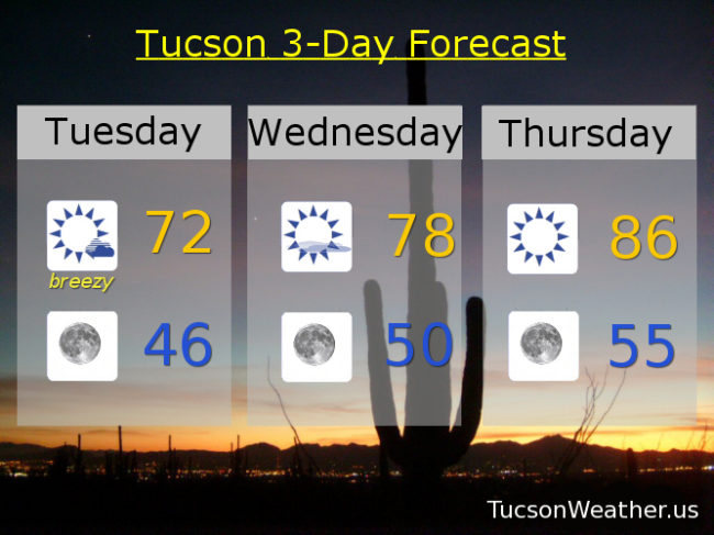
Becoming sunny this morning and breezy this afternoon with west northwest winds 15-25 mph gusting over 30 and a high in the low 70s.
Winds relaxing tonight with clear skies and a low in the mid 40s.
Sunny tomorrow with a high in the upper 70s.
Sunny Thursday mid 80s. Breezy Friday mid 70s. Low 70s Saturday. Upper 70s Sunday. Near 80 Monday.