Monthly Archives: September 2017

Forecast for Friday, September 15, 2017

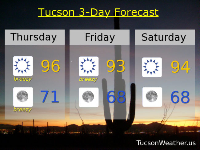
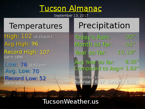
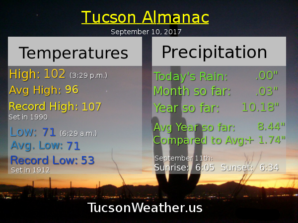
Systems to our north giving us breezy conditions once again today although maybe not quite as breezy as yesterday. Cooler air moving in with lows in the mid to upper 60s the next few mornings! Refreshingly cool. Cooler highs too. Moisture tries to increase next week with a slight chance for a storm or two, hopefully near you.

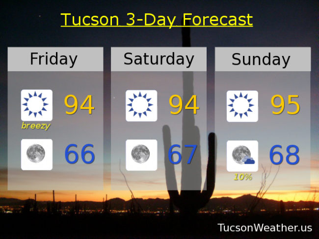
Sunny and breezy today with a high near 94 with SW winds 10-20 mph gusting over 25.

Winds relax tonight with a low by tomorrow morning in the mid 60s.

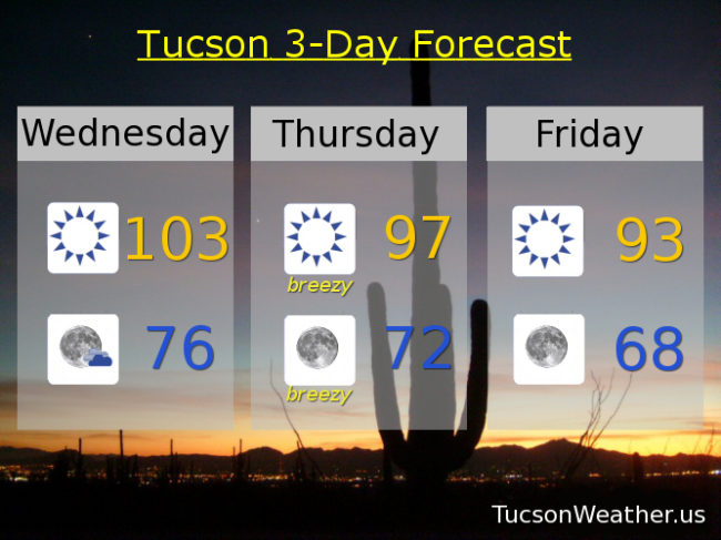
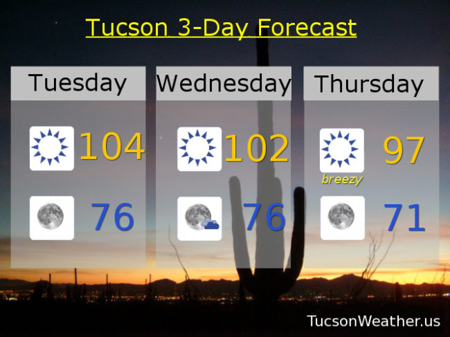
Sunny tomorrow and Saturday with highs in the mid 90s. A 10% chance for storms Monday 94ish. A 20% chance for storms Tuesday low 90s. Sunny low 90s Wednesday. Near 90 Thursday.

Forecast for Thursday, September 14, 2017

The winds of change and a taste of Fall blowing in with a cool front. A couple of systems to our north will bring snow to the northern Rockies. We’ll get some cooler air with refreshingly cool mornings coming up in the upper 60s! Some moisture returns starting Sunday for slight storm chances into next week.

Sunny today becoming breezy this afternoon with SW winds 15-25 mph gusting over 30 and a high in the mid 90s.

Breezy tonight with winds relaxing after midnight. SW winds 5-15 mph gusting over 25 and a low in the low 70s.

Breezy Friday with SW winds 10-20 mph gusting over 25 and a high in the low 90s. Upper 60s to start the day Saturday with highs in the mid 90s. Upper 60s to start the day Sunday with a 10% chance of an afternoon storm and a high in the mid 90s. A 20% chance for afternoon and evening storms Monday, Tuesday and Wednesday with highs near 95, 94 and 92. Enjoy!

Forecast for Wednesday, September 13, 2017

Not quite as hot as yesterday’s record of 106 today, but still kinda hot at 103sih. A cool front blows through tomorrow with SSW winds gusting to around 30 mph tomorrow and SSE winds gusting over 25 mph tomorrow night. Cooler behind the front with highs in the low 90s Friday and Saturday and lows in the upper 60s! That will be refreshingly cool 🙂 A slight chance for an isolated storm near you Sunday, Monday and Tuesday with highs near average for this time of year in the mid 90s.

Forecast for Tuesday, September 12, 2017

Who turned up the heat?! High pressure building back into Arizona will bring record heat to Tucson. It’ll be close at least. If the forecast comes exactly true we will miss the record of 105 set in 1943 by just a degree. Winds of change are coming and cooler air with it. A trough of low pressure moving through the Great Basin will kick up the winds Thursday and usher in “cooler” air with highs in the mid 90s to end the week and start the weekend. Our average high for this time of year is 96, so it will be nice to be average. The slightest chance of showers Sunday and Monday as Monsoon 2017 is all but finished.

Sunny today with a high near 104.

Clear skies tonight with a low in the mid 70s.

Sunny 102ish tomorrow. Breezy Thursday with SW winds gusting to around 30 mph by afternoon and a high in the upper 90s. Sunny Friday and Saturday near 94. A 10% chance for storms Sunday and Monday mid 90s.