Monthly Archives: January 2018

Forecast for Tuesday, January 16, 2018

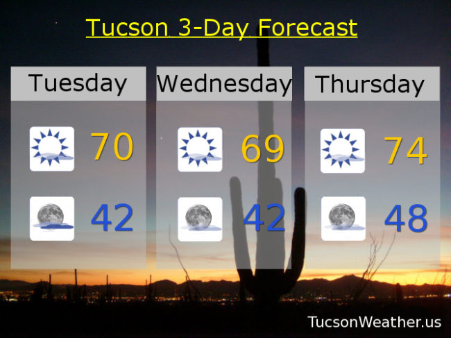
An Arctic plunge affecting much of the nation east of the Rockies will spill into southeastern Arizona. We won’t be frigid, but a backdoor cold front moving in from New Mexico will cool us off a bit here in the metro and a bit more dramatically to our east. East breezes picking up today 10-20 mph with a high near 70. Still 4 or 5 degrees above average for this time of year. High cloudiness too for sunrise and sunset enhancement possibilities.

Partly cloudy tonight with a low in the low 40s.

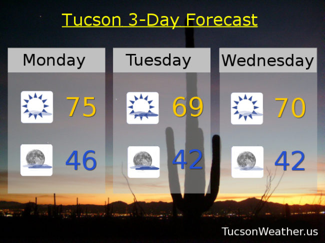
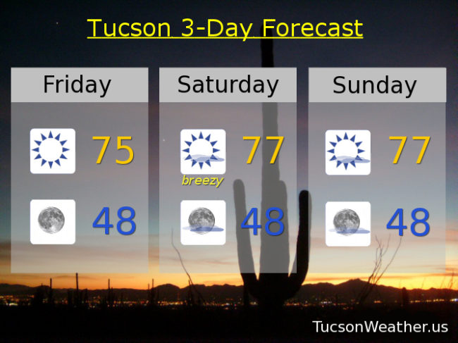
Mostly sunny tomorrow with a high near 70. Mid 70s Thursday and Friday.

A storm approacheth Friday night with a slight chance for light rain (half the calories of our regular rain). The storm and associated cold front blows through on Saturday with much cooler temperatures and a chance for showers with a high in the mid 50s! Snow levels dropping to near 4,000 feet. Lingering showers possible Saturday night and then clearing with a low near freezing.

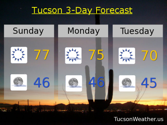
Sunny Sunday upper 50s. Near freezing Monday morning with a high in the upper 60s.

Forecast for Monday, January 15, 2018

Happy MLK Day!

High pressure still in control, but a system missing us to the north tomorrow will kick up our breezes and knock our temperatures down a few degrees. A storm moving through this weekend will gives a major cool down, but as it look snow, not a lot of rain and mountain snow.

Mostly sunny today with a few high clouds for possible sunrise and sunset enhancement and a high in the mid 70s.

Partly cloudy tonight with a low in the mid 40s.

Partly sunny tomorrow with east breezes 10-20 mph gusting to near 30 and a high near 70.

Mostly sunny 70ish Wednesday. low 70s Thursday. Mid 70s Friday.

A cold but somewhat dry storm moves through Friday night into Saturday with a chance for light rain and mountain snow overnight Friday into early Saturday morning. Snow levels could get as low as 3,500 feet!, but not a lot of accumulation. Becoming mostly sunny Saturday with a high in the upper 50s. Near freezing Sunday morning. Sunny Sunday near 60. Stay tuned!

Forecast for Sunday, January 14, 2018

High pressure remains in control. Yesterday’s high of 78 tied the record although the bar was pretty low since January 13th is the only day of the month with a record not in the 80s. Still, it is warm for this time of year. Upper 70s again today.

High clouds from time to time tonight into next week for possible sunrise and sunset enhancement. Mid 70s tomorrow. Near 70 Tuesday and a bit breezy. Low 70s Wednesday and Thursday. Mid 70s Friday.

A storm system moves through Friday night and Saturday. Unfortunately it looks like this storm won’t have a lot of moisture to work with so just a slight chance of rain Friday night. Much cooler Saturday with a high in the upper 50s. Stay tuned!

Forecast for Saturday, January 13, 2018

High pressure is back and our forecast highs are pretty high once again. Our clouds will be high as well. A series of storms missing us to the north will give us a few high clouds from time to time for possible sunrise and sunset enhancement. One such system will kick up our winds this afternoon out of the east 15-25 mph gusting over 30. As those east winds run downhill, the air compresses and warms and we will approach the record high of 78.

Mostly sunny upper 70s tomorrow. Mid 70s for MLK Day. Breezy low 70s Tuesday. Low 70s Wednesday. Mid 70s Thursday. Low 70s Friday. Enjoy!

Forecast for Friday, January 12, 2018

It’s Friiidaaay!

Our persistent area of high pressure that has been providing us with such a mild Winter is baaaaaack. Yesterday was pretty normal by early/mid January standards with a high of 67 after a low of 41 (averages are 65 and 40), but it’s back to the warm stuff today. Mid 70s with sunshine.

A low missing us to the north and east will kick up the winds tomorrow out of the ESE 15-20 mph gusting to near 30. Tomorrow’s high near the record high of 78.

Upper 70s on Sunday too to complete a warm weekend. Mid 70s on MLK Day with sunshine. Another storm missing us to the north will kick up the breezes again on Tuesday mid 70s. Mid 70s Wednesday. Low 70s Thursday.

We are still watching next weekend for the possibility of rain. Right now it looks like the storm will be just a bit too far north for us, but we’ll keep you posted of course.