Monthly Archives: January 2018

Forecast for Thursday, January 11, 2018

Happy Friday Eve! It makes the weekend seem closer…

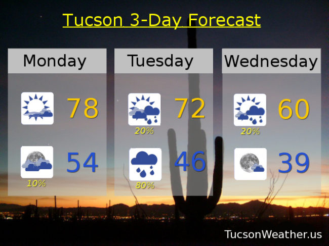
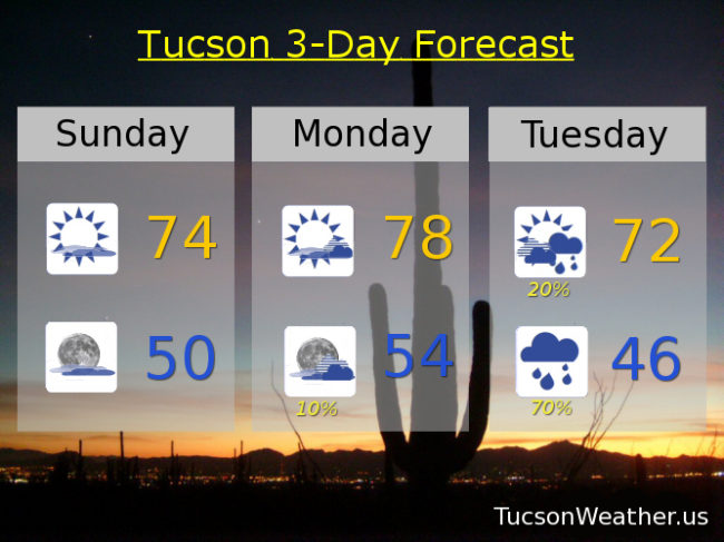
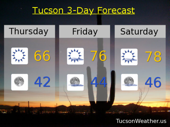
Our storm is no longer ours as it has headed east. We are left with cooler air behind the system today before high pressure builds back in and warms us back up. January 13th is the only day this month that doesn’t have a record of 80 or higher. If the forecast comes exactly true we will tie the record high of 78 on Saturday. Otherwise it’s high clouds from time to time for possible sunrise and sunset enhancement. Highs in the mid 70s Sunday through Wednesday.

Looking past the 7 day forecast to next weekend there is a hint of maybe another storm for a chance of showers and mountain snow. That’s still a long way off so we’ll just have to see how/if it develops. Stay tuned!

Forecast for Wednesday, January 10, 2018

Our upper low is currently over NE Arizona and is still sending showers our way this morning. The storm has over-performed rainfall-wise in Oro Valley and other northern Tucson locations with generally a half inch of rain or more. One rain gauge recorded 1.50″! Not sure where that was yet, but congratulations! Someone in OV is living right (hint; It’s not me). Meanwhile, the official rain gauge at the airport has only received a trace so far. Scattered showers still possible this morning (it’s raining right now in OV) with partial clearing by this afternoon becoming partly cloudy tonight. Sunshine returns tomorrow and still on the cool side. Mid 70s return Friday and that’s about where we will stay through Tuesday of next week. Enjoy!

Forecast for Tuesday, January 9, 2018

Here we go! A strong storm system is dropping flooding rains on parts of the California coast this morning. The low will head toward northern Arizona as we go through the day and move across tonight. Winds will be picking up as the storm approacheth today and moves through tonight. The computer models have backed off just a tad on rainfall amounts with the storm, but we still could see up to a half inch of rain in spots. Snow levels will start quite high but crash to near 5,000 feet by tomorrow morning. Still expecting 4-7 inches of snow above 7,000 feet with higher amounts possible above 8,000. The storm moves on to northern New Mexico by late Wednesday and we’ll be left with cooler temperatures for a day or two before we start to warm back up. Enjoy!

Partly sunny today with scattered showers possible by late afternoon and a high near 72.

Breezy tonight with south winds 10-20 mph gusting over 30 becoming WSW after midnight as the front moves through. Showers and possibly a thunderstorm (hopefully near you) before 2 a.m. then scattered showers. Low near 50.

Partly sunny tomorrow with isolated showers then clearing late in the afternoon and a high near 60.

Sunny Thursday 65ish. Mid 70s Friday, Saturday, Sunday and MLK Day.

Forecast for Monday, January 8, 2018

All systems go for tomorrow night’s storm! We are already starting to see an increase in clouds and moisture this morning. As the system gets closer we could see some light rain as early as later today or tonight. Isolated showers also possible tomorrow ahead of the main event tomorrow night. As the storm moves through with its associated cold front Tuesday night we’ll have a good chance for valley rain and mountain snow and maybe a few thunderstorms thrown in! Maybe. Snow levels start out above 8,000 feet falling to near 5,000 feet Wednesday morning. Could see 4-7 inches of snow above 7,000 feet before the storm moves out Wednesday. Up to a half inch of rain with some isolated higher amounts in valley locations. Lingering showers Wednesday morning with clearing skies during the day. Then we warm up by next weekend. Enjoy!

Partly sunny today with a high in the upper 70s.

Isolated showers possible tonight mainly after midnight with a low in the mid 50s.

Partly sunny tomorrow with a chance for isolated showers and a high in the low 70s.

Showers likely tomorrow night with possibly a thunderstorm. Breezy with SSW winds 10-20 mph and gusty becoming westerly after midnight. Low in the mid 40s.

Isolated showers possible Wednesday morning becoming mostly sunny with a high near 60.

Sunny Thursday mid 60s. Mid 70s Friday. Upper 70s Saturday. Low 70s Sunday.

Forecast for Sunday, January 7, 2018

High clouds overnight associated with a system moving through the Four Corners has kept some of the heat from escaping into space (echo: space, space, space… ). A mild start to another warm southern Arizona day with decreasing clouds today. Clouds will be on the increase tonight as our next storm approacheth. The forecast is still looking promising for valley rain and mountain snow! By tomorrow the system will be moving into southern California with a slight chance for light rain as early as tomorrow night. The main event will be Tuesday night as the storm moves through with showers lingering into the first half of Wednesday. Snow levels will start quite high; above 8,000 feet, but will crash perhaps as low as 5,000. Could see 4-8 inches above 7,000 feet so some sledding in the Catalinas might be in order. Valley locations still expecting up to a half inch of rain, perhaps a bit more. The storm keeps truckin’ so clearing skies Wednesday afternoon and a warming trend for the end of next week. Enjoy!

Decreasing clouds today with a high in the mid 70s.

Increasing clouds tonight with a low near 50ish.

Partly sunny tomorrow with a high in the upper 70s.

Isolated showers Tuesday with showers likely Tuesday night. High in the low 70s. Low in the mid 40s.

Scattered showers Wednesday morning becoming mostly sunny and a high near 60.

Sunny Thursday mid 60s. Mid 70s Friday and Saturday.