Monthly Archives: June 2018
Forecast for Tuesday, June 19, 2018
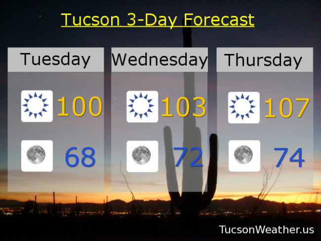
Bud, you were the best! But now you’re gone. Thank you for the rain and greening up the place a bit! We miss you. Now it’s just gonna get hot. So hot that the National Weather service has issued an EXCESSIVE HEAT WATCH for Friday, so watch for excessive heat. High pressure building in is the culprit. Still, a forecast high of 109 on Friday is still shy of the record of 114 set in 1988. It does get hot this time of year, but the morning’s are amazing for coffee on the deck. High pressure loosens it’s grip by the weekend for “cooler” temperatures. No rain in sight… yet. Stay tuned!
Sunny today with a high near 100.
Clear skies tonight with a low in the upper 60s.
103ish tomorrow. 107 Thursday. 109 Friday. 104 Saturday. 100 Sunday. 102 Monday.
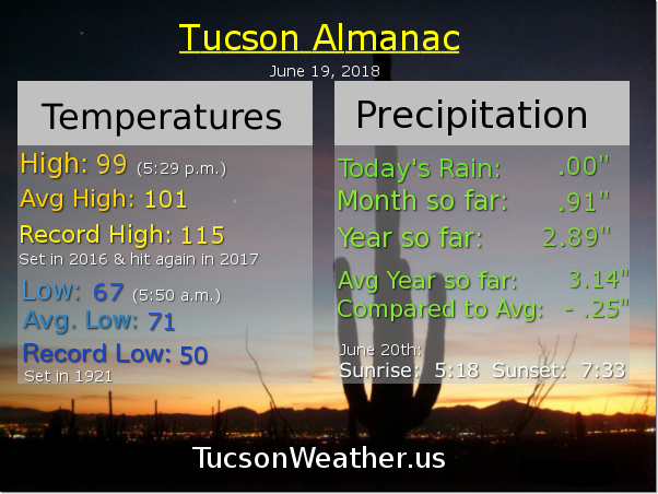
Almanac for Monday, June 18, 2018

Forecast for Monday, June 18, 2018
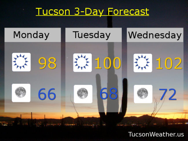
Now back to our regularly scheduled June weather. High pressure building in means high temperatures going up. Still about perfect on the deck for morning coffee. High temperatures peak on Friday when we might see our first 110 degree day of the year. Cooling off a bit for the weekend. Enjoy!
Sunny today upper 90s. Clear tonight mid 60s. Near 100ish tomorrow. 102 Wednesday. 106 Thursday. 109 Friday. 106 Saturday. 102 Sunday.
Almanac for Sunday, June 17, 2018

Forecast for Sunday, June 17, 2018
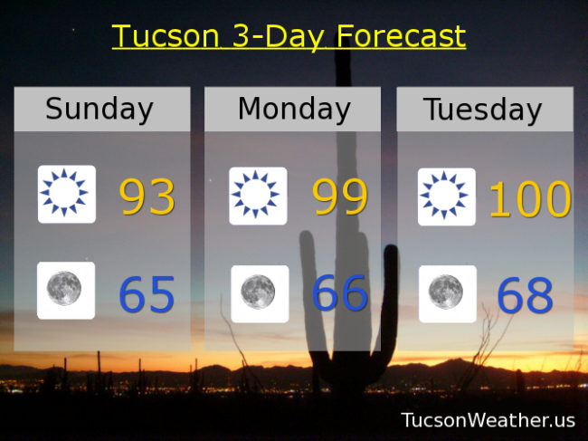
Well that was fun! Record rainfall yesterday for the second day in a row means we are off to a record start to Monsoon 2018! We ended up with .74″ at the airport yesterday with many locations around town picking up more and some much more. Thanx Bud! Also, yesterday’s high of 81 was the coolest high ever for a June 16th. Yesterday’s upper level low that helped turn all that moisture into showers and storms has moved off to the east and we are left with a drying and warming trend this week. Getting back to hot by the end of the week.
Sunny today with SE breeze becoming SWesterly this afternoon and a high in the low 90s.
Clear skies tonight and refreshingly cool tomorrow morning with a low in the mid 60s.
Upper 90s tomorrow. Near 100ish Tuesday. 101 Wednesday. 104 Thursday. 106 Friday. 105 Saturday. Enjoy!
Almanac for Saturday, June 16, 2018

Forecast for Saturday, June 16, 2018
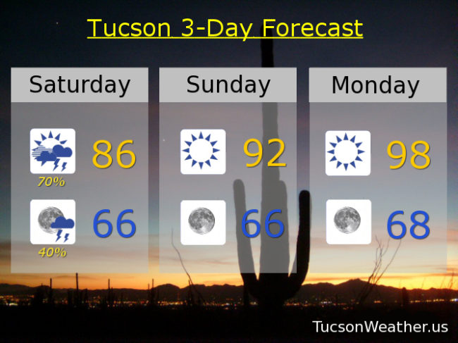
Monsoon 2018 is off to a record start! .17″ of rain before midnight broke the previous rainfall record of June 15th of .15″. Today looks like another record rainfall kind of day as an upper level low interacts with record to near record moisture levels for mid June. Look for showers and storms with locally heavy rainfall. As I type this at 6:15 a.m. there is a large area of moderate rain heading into the Metro! I just heard my first thunder of the season! Flash flooding may be a concern with this area of rain and with any storms we may see later, so please enjoy Monsoon 2018 responsibly.
A chance for storms continuing this evening with storms ending late tonight as the low clears the area. Tonight’s low in the mid 60s.
Sunshine returns tomorrow and we start to dry out and warm up. Low 90s tomorrow. Upper 90s Monday and Tuesday. Near 100ish Wednesday. 102 Thursday. 104 Friday. VIVA MONSOON 2018!
Almanac for Friday, June 15, 2018

Forecast for Friday, June 15, 2018
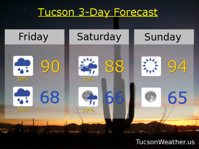
It’s here! Moisture from the remnants of Hurricane Bud have arrived on the first official day of Monsoon 2018. Pretty darn exciting! Already light rain showers across the area this morning. That is expected to increase as we go through the AM. Mostly light showers before Noon, but maybe enough to break the 5th longest dry streak in Tucson’s history. It’ll be a cloudy day as well, but if we do manage some breaks in the clouds that will increase our chances for a few thunderstorms, some of which may bring locally heavy rainfall. Today’s high near 90, if that. Record rainfall for June 15th is .15″. Let’s try to break that record! On top of all that, it’s Friiidaaay!!!
Cue Rod Stewart, “Tonight’s the Night”. Prime time for Bud to shine, er, I mean rain. Should be numerous showers with an embedded storm or two possible. Locally heavy rainfall also possible. Low tomorrow morning in the upper 60s.
Rain ending tomorrow morning, but an upper level low heading our way from southern California should move across the area giving us a chance for afternoon storms! Otherwise call it mostly cloudy with a high in the upper 80s.
A trough to our north should scour out our moisture on Sunday with sunshine and a high in the mid 90s. Mid 90s Monday. Upper 90s Tuesday. Near 100ish Wednesday and Thursday. VIVA MONSOON 2018!