Monthly Archives: March 2020

Forecast for Saturday, March 21, 2020

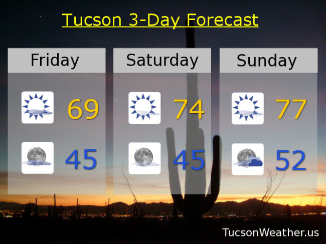
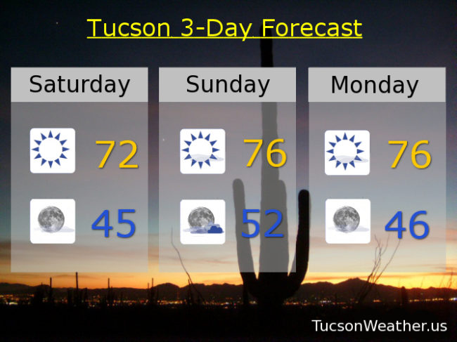
Best Spring Evah! So far anyway. Gorgeousness this weekend with Tons o’ Sun and highs in the low 70s today and mid 70s tomorrow. A few high clouds tomorrow for possible sunrise and sunset enhancement. Keep those photographical devices handy just in case.

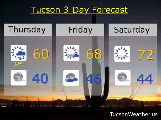
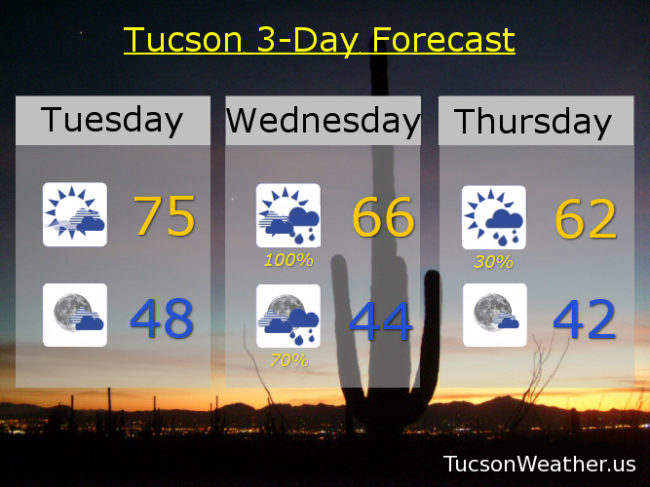
Beautimasness continues Monday with mostly sunshine and a high in the mid 70s. The hits just keep coming with upper 70s Tuesday and mid 70s Wednesday. A slight chance of rain in here Thursday upper 60s. Sunshine returns Friday upper 60s. Enjoy!

Forecast for Friday, March 20, 2020

It’s Friiidaaay!!!

The warm weather, she is upon us, no? Yes! I mean, it’s a chilly start to the day this morning (mmm chili), but pleasant enough by this afternoon with a high in the upper 60s. Increasing high clouds with perhaps sunset enhancement if the clouds don’t get too thick. Then it’s decreasing clouds tonight with a low in the mid 40s.

Beautiful weekend to practice social distancing! Mostly sunny skies mid 70s tomorrow. Upper 70s Sunday.

A mix of clouds and sun next week, but it’s good to be above average! Partly sunny Monday upper 70s. Mostly sunny Tuesday upper 70s to near 80ish. Partly sunny Wednesday upper 70s. A storm system missing us to the north will give us a glancing blow Thursday. A chance for showers upper 60s. Enjoy!

Climate Stuff:
Rain this week: .30″
Rain so far this year: 2.02″
Departure from average: – .26″
Rain so far this time last year: 3.74″

Forecast for Thursday, March 19, 2020

I love it when a good plan comes together! Additionally, I pity the fool who doubted the National Weather Service and their 100% chance of rain prediction for the desert! Bold move. Well play NWS. Well played.

.30″ fell at the airport yesterday before midnight and just a trace so far this morning. A few lingering showers about may add to our storm total. Of course your individual amount varied. Snow in them there hills. Summerhaven looks very wintry today. Clearing skies and cool this afternoon with a high only near 60ish. Clear tonight near 40ish (mmm chili).

Increasing clouds tomorrow but no rain expected. Warming up into the upper 60s. Sunny and nice as the weekend is still on track to be perfect for sheltering in place. Low 70s Saturday and upper 70s Sunday!

A series of systems will be moving through Arizona next week. A lot of uncertainty as far as specificity goes, but right now the best action looks like it will be mid to late week. Right now we’ll go with partly sunny Monday upper 70s. A slight chance (10%) for rain Tuesday mid 70s. 20% chance for showers Wednesday low 70s. Stay tuned and enjoy!

Forecast for Wednesday, March 18, 2020

Mike Mike Mike Mike Mike. What day is it Mike? The day of the sure thing?

So you’re saying there’s a chance. Not only that, but it’s a lock! I’ll put all my money on measurable rainfall today. The National Weather Service in Joe Namath style has guaranteed measurable rainfall today putting the chance at 100%. I was always told that if it’s too good to be true… But I trust our Meteorologists so I’m pushing all my chips to the center of the table. Seems like a good bet too. A storm system to our west should track right on through today and tonight. .25″ to .50″ of rain expected for valley locations and snow above 6,000 feet. Lingering showers tomorrow morning and then we clear out and warm up. The weekend looks fantastical! Then perhaps a bit of rain in here by Monday. Stay tuned.

Rain today and breezy fo sheezy with SSE winds 15-25 mph and a high in the upper 60s. Showers tonight low 40s. Showers linger perhaps tomorrow morning otherwise clearing skies and a high in the low 60s. Mostly sunny Friday upper 60s. Sunny Saturday mid 70s. Mostly sunny Sunday upper 70s. A 20% chance for rain Monday and Tuesday upper 70s. Enjoy!

Forecast for Tuesday, March 17, 2020

Just our luck. The wind returns! It’s blowing in rain and mountain snow with our next storm, so there’s that. Prime time will be tomorrow afternoon/evening. The weekend looks nice! Then a couple more storms moving in next week for a pinch more rain. Stay tuned!

The rest of the country might be green with envy. Decreasing clouds today with a high in the mid 70s. However. Breezy fo Sheezy with SSW winds 10-20 mph and gusty. Partly cloudy tonight upper 40s. Breezier fo Sheezier tomorrow with S winds 15-20 mph +. Showers and possibly a storm mid 60s. Lingering showers Thursday low 60s.

Sunny Friday upper 60s. Mostly sunny Saturday and Sunday mid 70s. Mostly sunny Monday AND a chance for rain mid 70s. Enjoy!