Nice! Upper 70s to near 80ish today. Amazing! Breezy fo Sheezy tomorrow as our next Winter storm approacheth. It’ll still be warm with a high in the mid 70s and SSW winds 10-15 mph and gusty.
Then it’s a 100% chance of rain on Wednesday. Low 60s for a high in the Metro. Snow levels dropping to 5,500 feet Wednesday night and likely lower Thursday morning. Lingering showers Thursday and a high only near 60ish.
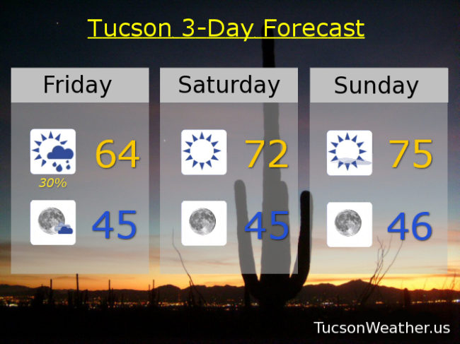
Back to sunshine Friday and warming up in time for the weekend. Upper 60s Friday. Mid 70s Saturday. 10% chance for showers Sunday low 70s. Enjoy!
Beware the Ides of March lest you get stabbed in the back by some brut. Otherwise, you should be good! Certainly the weather is both peachy and keen. Sunny today mid 70s. Our next storm approacheth and with it a few more high clouds tomorrow. Still. Mostly sunny upper 70s. A few clouds Tuesday and a bit breezy mid 70s.
Step right up for the main event as the next cold upper low rolls in. Prime time for the storm looks to be Wednesday afternoon, but plenty of action into Thursday. Accumulating snow above 6,000 feet with snow as low as 5,000 before all is said and done at the end of the day and other trite phrases. A chilly rain for the rest. A few thunderstorms may get thrown into the mix as well. Call it showers likely Wednesday otherwise partly sunny mid 60s. Showers Wednesday night mid 40s. Scattered showers Thursday low 60s.
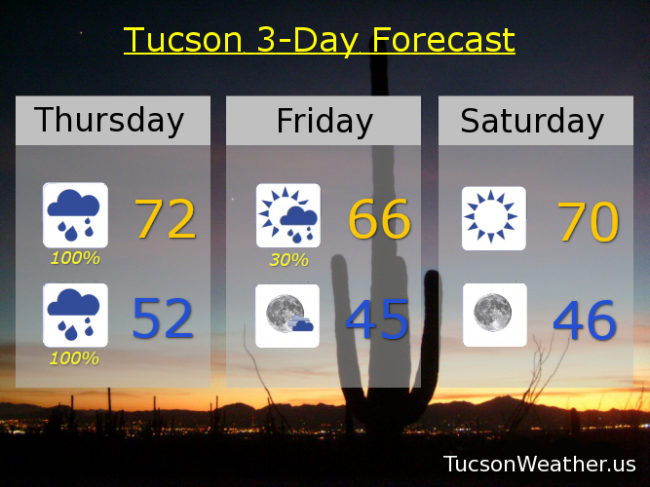
The storm is outta here in time for another nice weekend. Sunny Friday near 70ish. Mid 70s Saturday. Enjoy!
Great weekend for a hike! Alone. Far away from virus-ridden humans. Or. Stay at home and not watch March Madness on any of your streaming devices. Your call. Meanwhile, the Tucson Weather remains rather benign into early next week. That is until our next plot turn. Will an upper level low find happiness bringing showers to the desert southwest? Will the desert southwest’s thirst finally be quenched? How low will the snow go? To the answers to just one of these questions (if it comes true) is coming up next. Stay tuned!
It is a gorgeous weekend already in progress with a high today in the low 70s. Sunny mid 70s tomorrow.
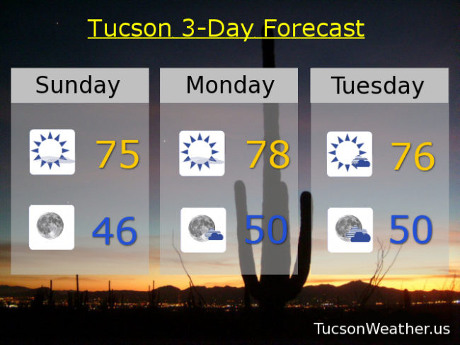
Mostly sunny and warm Monday upper 70s. Mostly sunny, breezy, and warm Tuesday upper 70s. Our next storm approacheth. Showers commencing perhaps as early as Tuesday night with showers likely by Wednesday and a high in the upper 60s. Showers likely Wednesday night and Thursday with mountain snow. Thursday’s high near 60ish. Snow levels dropping to as low as 5,000 feet Thursday night with lingering showers Friday becoming mostly sunny upper 60s. Enjoy!
It’s Friiidaaay!!! The 13th. It’s Friday the 13th. Dun dun dun… I never understood the big scare behind Friday the 13th. If you think about it, isn’t Monday the 13th much worser? Of course it is.
Meanwhile, some rain! Your individual totals may vary, but the airport only picked up .04″ yesterday and .14″ so far this morning (as of 4am). Lingering showers today as our low will actually move through the state in a weakened state. Plenty of sunshine today as well and cool with a high in the mid 60s. Clear and cool tonight with a low in the mid 40s.
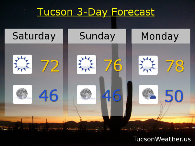
A slendiferous weekend shaping up with low 70s tomorrow. Mid 70s Sunday. Upper 70s Monday. Mid 70s Tuesday. Our next storm approacheth with a 50% chance for rain on Wednesday upper 60s. Rain likely Thursday low 60s. Enjoy!
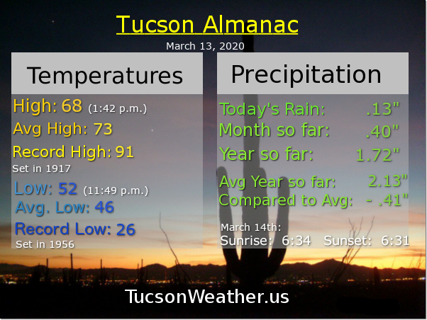
Climate Stuff: Rain Yesterday: .04″ March 12, 2019 Rain: .62″ Rain so far in March: .27″ Rain so far in 2020: 1.59″, .52″ below average Rain at this point last year: 3.74″
It’s Friday Eve! It actually makes the weekend seem closer, so there’s that.
OK. Let’s talk. I know you might be thinking that yesterday’s forecast was a bust. I mean, come on weatherdude, where was our promised rain? Some things to keep in mind. First. The airport did pick up .01″ of an inch yesterday morning (before you got up probably) so technically the 40% chance of measurable rain came true! I know what you are thinking. (and you’d be right) That was NOT the expectation put forth by the forecast. I get it. Weather forecasting is still an inexact science despite all the computer models and super smart men and women at the National Weather Service. The fact that the weather is still uncertain despite our best efforts is a feature as far as I’m concerned. It keeps life interesting! Besides. Weatherfolk make good punching bags 🙂
So. Would you trust me if I said today is the day?! Record amounts of moisture in the atmosphere for March combined with increasing instability should (should) lead to showers and storms today and tonight. Heavy rain is possible! Confidence is so high that the National Weather Service has put the rain chances at 100% for today and tonight. Prime time looks to be late today into the overnight hours. Then the storm moves on leaving us with our memories of what was (or wasn’t), along with a sunny relationship with the weekend. Don’t be sad that it’s over. Be glad that it happened! You know. If it does…
Showers and storms today and a high in the low 70s. Heavy rain possible tonight low 50s. Lingering showers tomorrow otherwise mostly sunny mid 60s.
Sunshine rules the weekend! Near 70ish Saturday. Mid 70s Sunday and Monday. Our next storm is promising rain (you give me, promises promises) and mountain snow. 20% chance for showers Tuesday low 70s. Showers likely Wednesday mid 60s. Enjoy!