
All posts by mike@mikeshaw.tv
Forecast for Saturday, June 3, 2017

Everybody into the pool! The big hurt is here for the entire seven day forecast as high pressure will be large and in charge. Be cool!
Sunny today with a high near 103.
Clear skies tonight with a low in the low 70s.
Sunny tomorrow with a high near 103. 105 Monday. 106 Tuesday and Wednesday. 105 Thursday. 103 Friday.
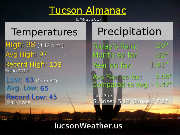
Almanac for Friday, June 2, 2017
Forecast for Friday, June 2, 2017
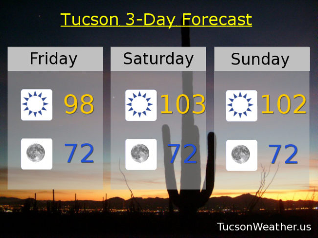
It’s a dry heat. You know, like an oven 🙂 High pressure building in for our first extended run of 100+ degree days just in time for the weekend. Enjoy!
Sunny today with a high in the upper 90s.
Clear skies tonight with a low in the low 70s.
Sunny tomorrow 103ish. 102 Sunday. 105 Monday and Tuesday. 103 Wednesday. 104 Thursday.
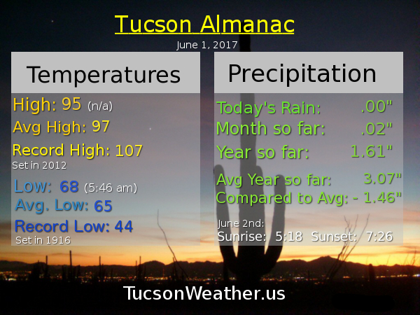
Almanac for Thursday, June 1, 2017
Forecast for Thursday, June 1, 2017
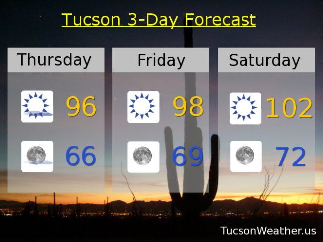
Happy Friday Eve! Makes the weekend seem closer. It’s also June 1st which is the first day of Summer meteorologically speaking. Of course June is also our hottest month around these parts, so there’s that. Just a little cooler today as our weak low is taking it’s sweet time exiting the state. It will be taking these mid and high level clouds with it as the day rolls on. Then high pressure builds in and flexes its muscles for a warming trend and 100+ degree days right into next week. Enjoy!
Decreasing clouds today becoming mostly sunny with a high in the mid 90s.
Mostly clear tonight with a low in the mid 60s.
Sunny tomorrow upper 90s. Near 102 Saturday and Sunday. 104 Monday. 103ish Tuesday and Wednesday.
Almanac for Wednesday, May 31, 2017

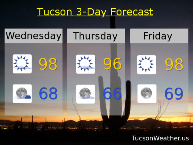
Forecast for Wednesday, May 31, 2017
I can’t afford a promotions department so I will have to toot my own horn (sounds painful). Yesterday I mentioned that if storms to our east formed a bit closer than expected we could see outflow winds in the afternoon/evening gusting to 40 mph. While they weren’t quite that we did get some fairly strong outflow breezes yesterday evening. Chances are this is the only place that gave you a heads up yesterday although I could be wrong about that. Anyway, thanx for reading, liking, sharing and considering becoming a Patreon. This is how I start my day 7 days a week for over the last several years!
Anyway… moving forward, our exiting low will give us lingering clouds into tomorrow for possible sunrise and sunset possibilities! Storms possible east of the Metro again this afternoon and evening. A bit cooler too to start June, but here comes the big hurt starting the weekend! Ah June. If we can survive you the rest of the Summer is gravy. (mmm gravy)
Mostly sunny today with a high in the upper 90s.
Partly cloudy tonight with a low in the upper 60s.
Mostly sunny tomorrow mid 90s. Upper 90s Friday. Near 103 Saturday. 104 Sunday. 103 Monday, Tuesday and Wednesday.
Almanac for Tuesday, May 30, 2017

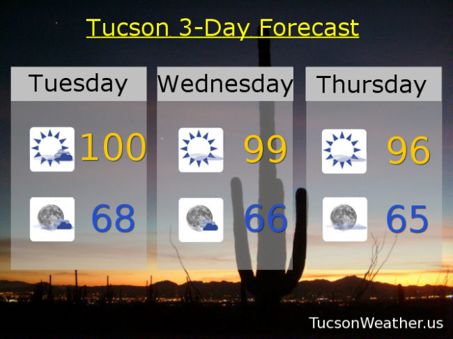
Forecast for Tuesday, May 30, 2017
Back to the salt mines for most of us. I have lots of watermelon left over from yesterday, so there’s that! More moisture and more clouds today as a weak low combined with an increase in moisture will give us a chance for storms south and east of Tucson. If those storms form close enough to us we may see some gusty outflow winds move through the metro later this afternoon/evening. It may not happen, but something to watch. More clouds as a result as well which will likely lead to sunset enhancement tonight. A little cooler the next couple of days behind the low. As you can imagine we will warm up by the first weekend of June, because, June! Back to the triple digits. Enjoy!
Mostly sunny today with a high near 100. SW winds 10-15 mph. Winds up to 40 mph IF thunderstorm outflow winds reach us by this evening.
Partly cloudy tonight with a low in the upper 60s.
Mostly sunny tomorrow upper 90s. Mid 90s Thursday. Upper 90s Friday and Saturday. Near 101 Sunday and Monday.