
All posts by mike@mikeshaw.tv
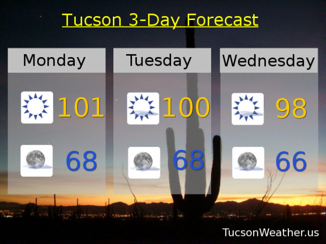
Forecast for Monday, May 29, 2017
Just beautiful on the deck this morning. A nice and cool start to a warm Memorial Day with nuthin’ but Sun. Moisture on the increase to our east, but it shouldn’t quite get to us this week. Just a few more clouds and slightly cooler as a weak system moves across the state Wednesday through Friday. Perhaps some sunrise and sunset enhancement possibilities! Heating up again by next weekend. Have an amazing Memorial Day as we remember the sacrifice of those who were willing to give all for our freedoms.
Sunny today near 101.
Mostly clear tonight near 68.
Mostly sunny tomorrow near 100. Upper 90s Wednesday. Mid 90s Thursday and Friday. Upper 90s Saturday. Near 101 Sunday.
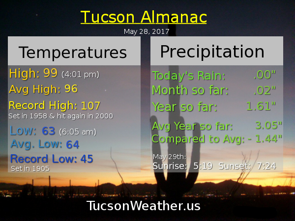
Almanac for Sunday, May 28, 2017
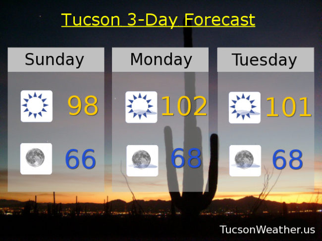
Forecast for Sunday, May 28, 2017
The triple digits return soon but only for a couple dayz. Then back near normal (96ish) by the end of next week as a bit more moisture sneaks in for a chance of a storm or two well to our east. Also a few more clouds for possible sunrise and sunset enhancement. Enjoy!
Sunny today with a high near 98.
Clear skies tonight with a low in the mid 60s.
Sunny tomorrow near 102. Near 101 Tuesday. Upper 90s Wednesday. Mid 90s Thursday and Friday. Upper 90s Saturday.
Almanac for Saturday, May 27, 2017

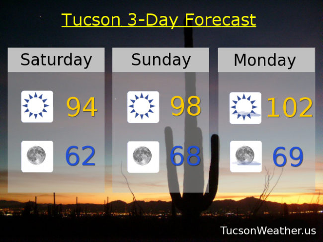
Forecast for Saturday, May 27. 2017
We are done with RED FLAG WARNINGS. (I never did see a red flag) Please continue to use common sense setting stuff on fire and stuff. It’s still really dry out there. Just lighter winds to fan the flames. High pressure building back in with tons of Sun and warmer temperatures this weekend. An increase in moisture may lead to a storm or two mainly to our east and in the higher terrain. (first time I’ve used the word “terrain” in a forecast!) It’ll also lead to a few more clouds for possible sunrise and sunset enhancement! Enjoy!
Sunny today with a high in the mid 90s.
Clear skies tonight with a low in the low 60s.
Sunny tomorrow upper 90s. Near 102 Memorial Day. Near 100 Tuesday. Mid 90s Wednesday, Thursday and Friday.
Almanac for Friday, May 26, 2017

Forecast for Friday, May 26, 2017
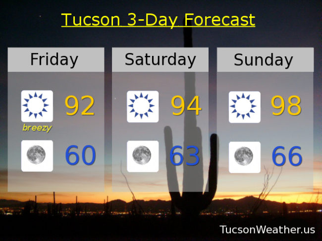
It’s Friiiiidaaaayy! Heading into a three day weekend to boot. Another breezy “cool” day before high pressure builds back in for a warmer Memorial Day weekend. Increasing moisture and a weak low will give areas to our east a slight chance of a storm or two by mid next week, but we shall stay high and dry here in Tucson.
Sunny and breezy today with SW winds 15-25 mph gusting to 35 and a high near 92. Average high for this time of year is 95.
Clear skies tonight with winds relaxing overnight and a low near 60. Average low is 63.
Sunny mid 90s tomorrow. Upper 90s Sunday. Near 100 Memorial Day. Upper 90s Tuesday. Mid 90s Wednesday and Thursday.
Almanac for Thursday, May 25, 2017

Forecast for Thursday, May 25, 2017
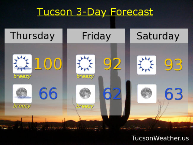
Happy Friday Eve! Makes the weekend seem closer. Which is good because we are gonna have to put up with a bit of wind nonsense between now and then. Fire danger is high so the National Weather Service has issued a RED FLAG WARNING for this afternoon and evening and ditto for tomorrow. Please for the love of everything that is right and good if you smoke keep your butt in the car. Also be careful if you like to set stuff on fire. Maybe resist the urge for a couple of days. Calming down and warming back up for the Memorial Day Weekend! Then a surge (OK, surge is too strong) of moisture moves our way and we have a slight chance of a thunderstorm or two! More thunder than storm so another chance at fires. Stay tuned and stay not on fire!
Mostly sunny and breezy today with SW winds 15-25 mph gusting over 30 and a high near a hunderd.
Mostly clear skies tonight with breezes dying down overnight for the most part and low in the mid 60s.
Sunny and breezy tomorrow with a SW winds 15-25 mph gusting to around 35 and a high in the low 90s. Sunny low 90s Saturday. Upper 90s Sunday. Near 101 Memorial Day. Slight chance for a storm Tuesday near 99. Mostly sunny Wednesday upper 90s.