
Almanac for Wednesday, December 17, 2019
Mike Mike Mike Mike Mike… What day is it Mike? It’s one week before Christmas! The last hustle and bustle weekend before the big day looks amazing. A big change in the weather pattern next week looks like it will bring us a couple of storm systems. Rain and mountain snow early next week into Christmas Day and another later in the week. We are a ways away, so still time to fine tune those details. In other words, we’ll burn that bridge when we get to it. Stay tuned!
In the meantime, everyone knows it’s Windy! East breezes kicking up again today with high clouds from time to time for possible sunrise and sunset enhancement. East winds 15-25 mph gusting to near 35 and a cool high in the low 60s.
Mostly clear tonight with winds relaxing and a low in the mid 30s.
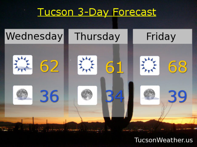
Sunny low 60s tomorrow. Upper 60s Friday. Low 70s Saturday. Increasing clouds Sunday as our first storm approacheth with a high in the upper 60s. Slight chance for showers Monday low 60s. Showers likely Tuesday (Christmas Eve Day!) low 60s. Enjoy!
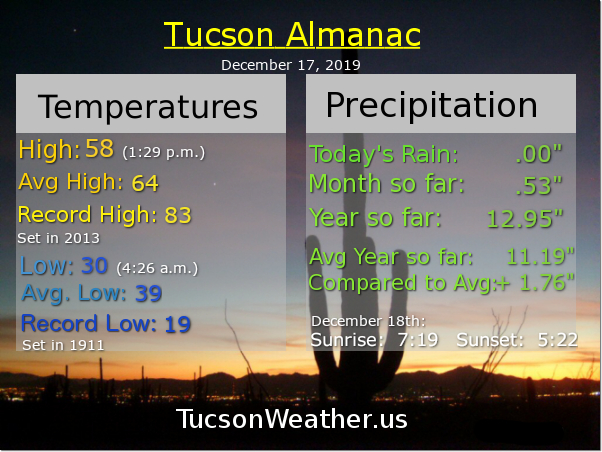
It’s freezing out there! Well. For most locations. Lows so far this morning range from the upper 20s to the mid 30s with a crisp 32 degrees at the airport as I scribble this out on my PC. A FREEZE WARNING remains until 9:00 a.m., so hopefully the teenagers were let back in the house last night. The big weather stories are; the wind for the next couple of days, a warm weekend, and a pattern change that should open the door to rain and mountain snow just in time for Christmas! Hold on to your chapeau, here we go!
Sunny, breezy (OK, windy, depending on where you are), and cool today with east winds 15-25 mph gusting to around 35 and a high in the upper 50s.
Breezier tonight with winds gusting to near 40 (for some) and a low in the upper 30s.
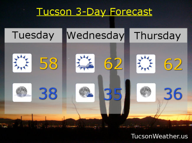
Partly sunny and breezy fo’ sheezy tomorrow. East winds gusting to near 40 and a high in the low 60s. Winds relax Thursday with sunshine and a high in the low 60s. Sunny and warmer as we head into the weekend. Upper 60s Friday. Mostly sunny mid 70s Saturday! Partly sunny mid 70s Sunday! A slight chance for showers Monday as our weather pattern starts to change. Monday’s high in the low 70s. Stay tuned!

Happy Monday! (it could happen) Cooler and drier air is settling into Arizona and as a result it is cooler and drier. (weird, I know) It’ll be chilly most of the day today and tomorrow. (mmm Chili’s! (maybe they should sponsor Tucson Weather?!)) Cold tonight with a FREEZE WARNING in effect. Be warned. It’s probably gonna freeze. Breezy tomorrow and Wednesday with a bit of warming starting Wednesday. The last weekend of hustling and bustling before Christmas looks great! Still watching for some sort of storm for Christmas Eve/Christmas Day. The timing, track, and strength are all still up in the air. (see what I did there?) Even though I’m heading to Texas for the holiday, I’ll still keep you posted. (pretty sure they have the internet in Texas) Stay tuned!
Sunny and cool today with a high in the upper 50s. FREEZE WARNING tonight with a low of freezing. Colder near washes and on the NE side.
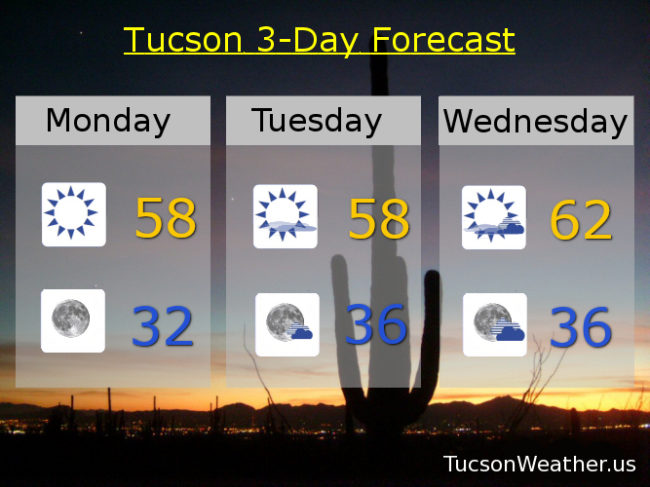
Mostly sunny and breezy tomorrow. East winds 15-25 mph gusting over 30 and a high in the upper 50s. Partly sunny and breezy Wednesday with east winds gusting to near 40 and a high in the low 60s. Sunny Thursday low 60s. Upper 60s Friday. Mid 70s Saturday and Sunday. Enjoy!

Christmas is approachething! A snow storm getting its act together in Colorado and moving into the plains will miss us well to the north. However. It will drag some cooler air into the Grand Canyon State. Sometimes it’s good to be below average. You know. If it helps get you in the Christmasy mood. It’ll stay dry for now, but Christmas Eve is looking interesting for maybe some rain and mountain snow. A white Christmas in Summerhaven? That is a ways away. We’ll keep you posted as we go. Here’s what we are more certain of…
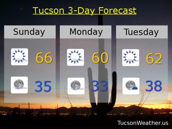
Mostly sunny today with a few high clouds for possible sunset enhancement. High in the mid 60s. Chilly (mmm chili) tomorrow morning with a low in the mid 30s. Mostly sunny tomorrow near 60ish. More chilly (yes please!) Tuesday morning near freezing. Tuesday’s high in the low 60s. Partly sunny Wednesday mid 60s. Sunny Thursday mid 60s. Upper 60s Friday. Mostly sunny low 70s Saturday. Enjoy!

A beautiful 75 degrees yesterday and we do it again today with tons o’ Sun! Don’t get used to it. A cool down is on the way. It’s cool to be cool. (so I’ve heard) A storm missing us to the north will usher in a bit of a chill as it exits stage east by tomorrow. Could see some freezing temperatures in the metro near the washes and other colder prone areas Tuesday morning. Yeppers. Serving up some chilly! (mmm chili) A few high clouds for possible sunrise and sunset enhancement as well. A storm late in the week will miss us to the north keeping us from warming up too much. No rain or mountain snow expected. Let’s detail the details…
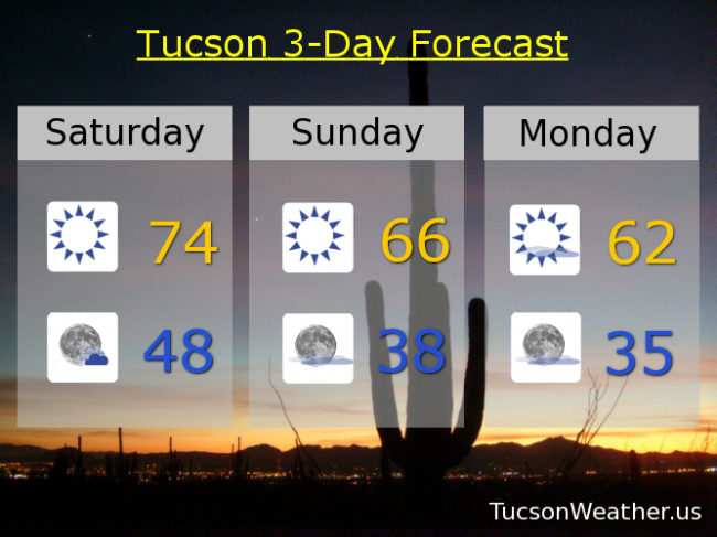
Sunny mid 70s today. Partly cloudy tonight upper 40s.
Cooler tomorrow mid 60s. Upper 30s tomorrow night. Mostly sunny low 60s Monday. Mid 30s (officially) Tuesday morning. Low 60s Tuesday and Wednesday. Mid 60s Thursday. Upper 60s Friday. Enjoy!