It’s beginning to look a lot like Christmas. Not everywhere you go, but kinda. In the stores for sure. Probably in your house too if you put up the tree and stuff. The weather not as much unless you live in Summerhaven. Perhaps up to 6 inches of new snow from our next storm. Rain by tomorrow for us lowlanders with primetime being tomorrow night into Thursday morning.
Increasing clouds today as our next storm approacheth. High in the low 70s.
A slight chance of a sprinkle or light shower tonight. Really not worth mentioning. (oops, too late) Low in the low 50s.
Mostly cloudy tomorrow with a chance for rain low 70s. Partly cloudy by Thursday with a slight chance for a lingering shower in the morning mid 60s. Mostly sunny Friday and Saturday low 70s. Mostly cloudy Sunday with a chance for showers upper 60s. Partly sunny Monday low 60s. Enjoy!
Happy Monday! It could happen. Also, it’s Cyber Monday meaning deals on stuff across the interwebs. So. I’ve decided to offer you FREE forecasts all this week. They might even come true. Who knows? Hey. You get what you pay for 🙂
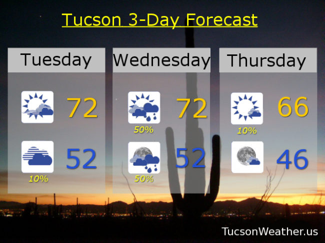
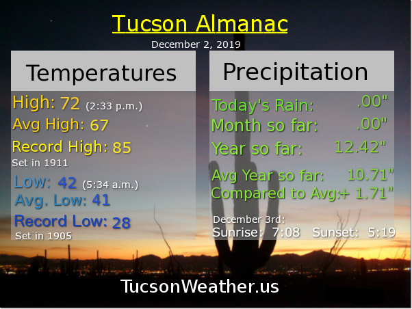
High pressure with us today and tomorrow for very pleasant temperatures to start December. Increasing clouds today low 70s. Becoming cloudy tomorrow mid 70s.
Our next storm approacheth bringing a good chance for valley rain and mountain snow. Not nearly as powerful as the last storm and the snow levels will be a bit higher. Showers on Wednesday near 70ish. Rain likely Wednesday night near 50sih.
A bit cooler as the system exits stage east. Partly cloudy mid 60s Thursday. Partly sunny Friday low 70s. Another storm this weekend, but only a glancing blow as it will be a bit north of us. Partly sunny Saturday upper 60s. 20% chance for showers Sunday mid 60s. Enjoy!
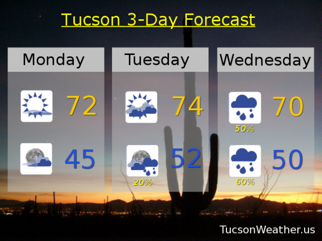
December already! Just seems like yesterday it was November. Crazy times. December 1st is the 1sy day of Winter, Methodologically speaking, so welcome to Winter. Kinda feels like it out there this morning, but that will change for a few days as high pressure is building in before our next storm approacheth. Actually two storms. One for Wednesday/Thursday. The one after that for the weekend. Everybody loves a parade!
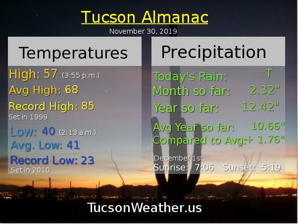
Sunny today with a high in the upper 60s.
Clear tonight low 40s.
Mostly sunny tomorrow low 70s. More clouds tomorrow night into Tuesday. Tuesday’s high mid 70s. A 50% chance for rain Wednesday near 70ish. 20% Thursday mid 60s. Mostly cloudy Friday 70. Slight chance for showers Saturday near 70. Enjoy!
Here comes a cold front! If it hits you like it did us here in Phoenix at 4:00 a.m., look out! I swear a couple of trees were gonna blow down! They didn’t, but wow, that was exciting! Good thing standing in long lines at 4:00 a.m. for Black Friday isn’t a thing anymore. (is it?) Either way, strong winds ahead of the front and as it passes this morning. Still expecting valley rain and massive mountain snow today. .5″ to 1.5″ inches of rain possible. 1 to 2 feet of snow above 7,000 feet (I’m looking at you Summerhaven) and 3 feet or so at Ski Valley. Exciting times!
FLASH FLOOD WATCH in effect until 5:00 this evening and a WIND ADVISORY until 2:00 this afternoon, so be advised, it’s windy. Wind gusts over 30 mph with a 100% chance of rain. Winnie the Pooh and the Blustery Day would be proud. (silly ol’ bear) Today’s high in the upper 50s.
Clearing skies by tonight if not sooner with perhaps a lingering shower and a low in the upper 30s.
Cool tomorrow after that chilly start (mmm chili) and a high in the upper 50s.
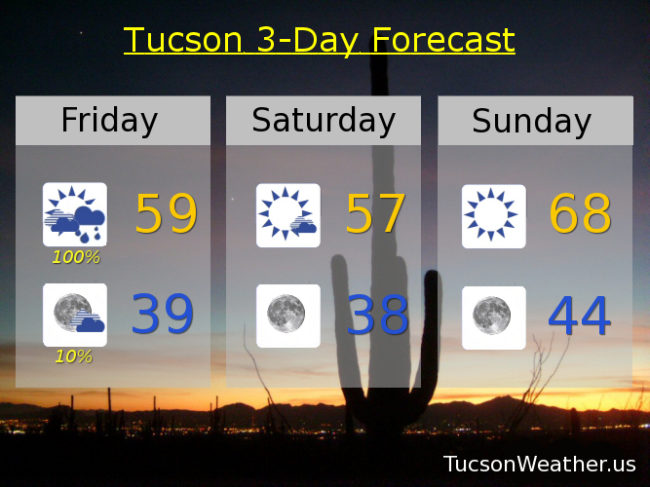
Sunny Sunday upper 60s. Low 70s Monday. Partly sunny Tuesday low 70s. A 20% chance for showers Wednesday near 70ish. 30% Thursday upper 60s. Enjoy!
Happy Thanksgiving! I can smell your roasting turkey from here. Amazing! Is it irony or coincidence that turkeys go “gobble gobble gobble”? What time is dinner? 🙂
Our Winter storm approacheth with wind and rain and literally tons of mountain snow. (seriously. If you weigh all the snow it will easily weigh tons) The associated cold front with our approaching storm is currently in western Arizona. It will hang out there through this afternoon before heading east and moving through these parts tonight. Winds and rain chances will increase as it gets closer and moves through. Snow levels are currently around 8,000 feet. Those will slowly sink to 7,000 feet and then down to 5,000 feet by tomorrow morning. 6 inches of snow or so possible above 6,000 feet. 1 to 2 feet perhaps above 7,000. Could see 3 feet or more at Ski Valley! Just epic if it comes true. For Summerhaven a FLASH FLOOD WATCH is in effect from 5:00 tonight until 5:00 tomorrow night. A WIND ADVISORY begins at 11:00 tonight and ends at 2:00 tomorrow afternoon. Be advised, it’s gonna be windy with winds gusting to 60 mph to blow that heavy snow around! A WINTER STORM WARNING is in effect from 11:00 tonight until Noon tomorrow. If I could afford a cabin up there I’d head up today, start a fire in the fireplace, and enjoy the show!
This is Tucson Weather, so let’s go over the 411 for the Old Pueblo. A 40% chance for showers this morning otherwise mostly cloudy today with a high in the upper 60s.
A FLASH FLOOD WATCH begins tonight at 11:00 and lasts until 5:00 p.m. tomorrow. Cloudy tonight with showers likely. A WIND ADVISORY from 11:00 p.m. tonight until 2:00 tomorrow afternoon. Winds tonight out of the south 25-35 mph gusting to 50! Low in the upper 40s.
Heavy rain possible with wind tomorrow. In other words, quite blustery! WSW winds 20-25 mph gusting over 35. The rain should start to taper off by afternoon but still breezy with showers about. High in the upper 50s.
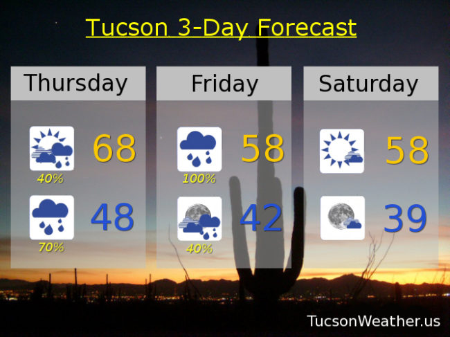
Scattered showers Friday night before midnight becoming partly cloudy by Saturday morning. The Sun returns Saturday with a few clouds and a high in the upper 50s. Sunny Sunday 68ish. Partly sunny Sunday and Monday low 70s. Scattered showers Wednesday as our next storm moves in! High in the upper 60s. Enjoy!