Almanac for Friday, November 22, 2019
It’s Friiidaaay!!!
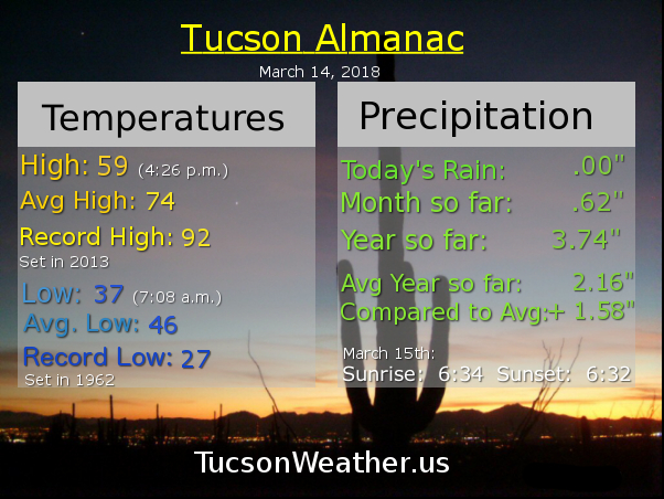
That was fun! 1.33″ of rain in the last 3 days! We are now over an inch above average for the year. It’s good to be above average!
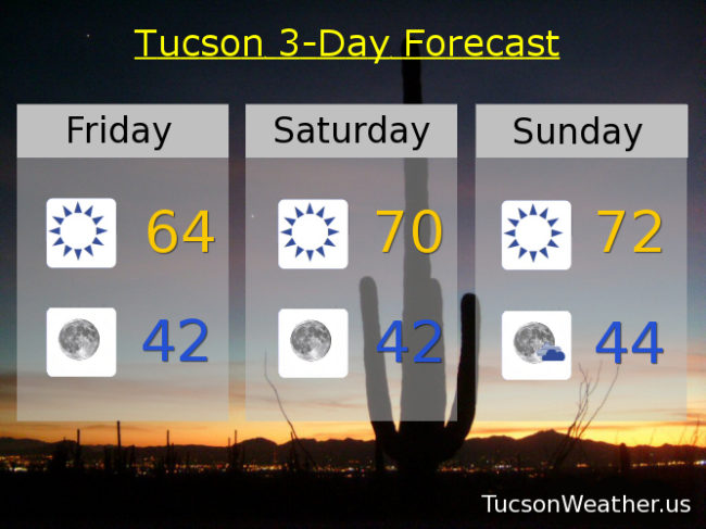
Storms have skedaddled for now and a warming trend will bring us to near average highs this weekend (71 for this time of year). Lows the next 2 mornings will be, yes, chilly (mmm chili). Or brisk if you are growing weary of chili every morning. 🙂 Rain for Thanksgiving? It’s looking like it… Here’s Mike with your forecast.
(best announcer voice) Sunny today after a cool start in the mid 40s. This afternoon’s high in the mid 60s.
Clear skies at night with a low in the low 40s.
Tons of Sun this weekend with a high near 70ish tomorrow and low 70s Sunday. Low 70s on Monday too.
A few more clouds and a bit cooler Tuesday as our next storm system approacheth. High in the upper 60s. Isolated showers Wednesday upper 60s. Scattered showers Thanksgiving day mid 60s. Keep it locked on Tucson Weather for your daily weather fix.

It’s Friday Eve! (makes the weekend seem closer)
Record rainfall yesterday! (see previous post) Already about a half inch of rain since midnight with showers still lurking this morning. (see future post) This Winter is off to an amazing start and it’s not even Winter yet 🙂
The FLASH FLOOD WATCH expires at 8:00 this morning as our storm will be winding down tonight. The WINTER STORM WARNING for Summerhaven is in effect until 11:00 tonight. Nearly a foot to a foot and a half of snow possible in them there hills! Meanwhile back at the ranch, rain in the forecast today as the main low currently located in NW AZ moves through along with a cold front. A thunderstorm is possible too, hopefully near you! Yes, it’ll be chilly (mmm chili) with a high only in the upper 50s!
Shower chances hangin’ in there before midnight tonight and then just mostly cloudy and cool with a low in the mid 40s.
Sunshine returns tomorrow with a bit of a warming trend through the weekend. Low 60s tomorrow. Upper 60s to near 70 Saturday. Low 70s Sunday and Monday. Upper 60s Tuesday. Another storm possibly moving our way in time for the Thanksgiving weekend! A 20% chance for rain Wednesday mid 60s. Stay tuned!

Record rainfall for the date! Now over half an inch above average for the year with more rain (and mountain show) in the forecast.
Mike Mike Mike. What day is it Mike? If you said, a blustery day, you would be correct! More on that in a few sentences.
Just over a third of an inch of rain yesterday at the International Airport. Your individual rain totals from yesterday may vary of course. Visit rainlog.org after 7:00 a.m. to get the latest amounts near you.
Our first storm will still be messing with us today with showers and gusty winds. SSW breezes gusting near 35 mph at times! Hold on to your hat, put rocks in your pockets, skirt alert, etc. Perhaps extra hairspray or gel as well. (do people still do that?) Only upper 60s this afternoon, so grab a jacket, preferably your own.
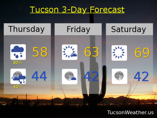
As our first storm departeth our second approacheth. This one is colder and will bring mountain snows down to 7,000 feet tonight. A couple few inches of snow for Summerhaven possible overnight with rain, heavy at times for bottom dwellers. Down near 50ish for a low,
Showers likely tomorrow with mountain snow. High only in the upper 50s. Showers continue tomorrow night with a low in the mid 40s.
Then our second storm leaves us and we think maybe it’s moving on just a little too easily. What about our need for rain and mountain snow? don’t you care?! (clears throat) Sorry. Where was I? Oh yeah. Clearing up Friday and the Sun returns to us! Low 60s by afternoon. Partly cloudy Friday night with a low in the low 40s Saturday morning. (mmm chili)
Mostly sunny Saturday upper 60s. Low 70s Sunday. Upper 60s Monday. Low 60s Tuesday. Will we see another storm next week. Stay tuned!
Good Morning! And happy Twofer Tuesday! (I pretty much ripped that off from every Classic Rock station everywhere). Sorry I’ve been gone so long and this doesn’t mean I’m back back, but I miss you and maybe we can hang out like old times. I can’t commit long term, but maybe we can have a few laughs?
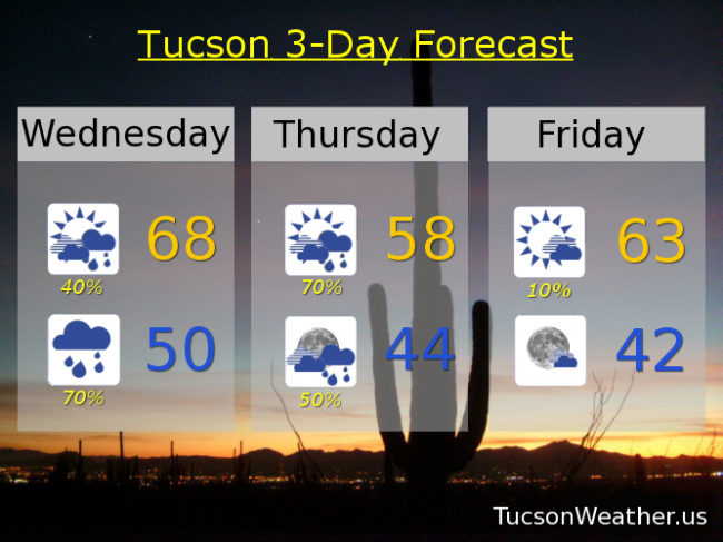
FLASH FLOOD WATCH begins at 11:00 this morning as our first storm approacheth. The FFW lasts until 11:00 p.m. Wednesday night. It’s a sorted tale of two storms that will bring rain and mountain snow and joy to the hearts of Arizonans everywhere.
Lots of action expected starting this afternoon. Near record moisture levels being pulling into southern Arizona ahead of our first storm now located in Baja California. As the storm gets closer this afternoon we could see severe storms mixed in with our regular storms and showers. Damaging winds anybody? No thanx, I’m good. Heavy rain at times will be possible as well possibly leading to flooding. Please enjoy our weather pattern change responsibly. (this message brought to you by turn around don’t drown and the ad council) High today still near 80.
Storms, some possibly severe and or with heavy rain possible, along with showers this evening. The severe threat ends after sunset, but the locally heavy rain chances remain overnight. Your individual mileage may vary. Low tonight in the upper 50s.
A bit of a break in the action tomorrow as storm one exits stage NE and storm two approacheth from our friends in Nevada. (Thank You Nevada!) Still a 50% chance for rain tomorrow and breezy. A cooler high in the upper 60s. Rain ramps back up tomorrow night with a low in the upper 40s. Snow levels dropping tomorrow night with a WINTER STORM WATCH in effect. My personal preference would be to drive up to Mt. Lemmon and watch the storm! Could be over a foot at Ski Valley before all is said and done at the end of the day and other trite phrases. Summerhaven may be your haven for snow. Snowhaven has a nice ring to it, dontcha think?
Rain still likely on Thursday with snow above 6,500 – 7,000 feet. Tucson with a high near 60ish. Storm two winding down by Friday with sunny but cool weather for the weekend. Upper 60s Saturday. Low 70s Sunday. A slight chance for showers Monday upper 60s. Enjoy!