Mike Mike Mike. What day is it Mike? If you said, a blustery day, you would be correct! More on that in a few sentences.
Just over a third of an inch of rain yesterday at the International Airport. Your individual rain totals from yesterday may vary of course. Visit rainlog.org after 7:00 a.m. to get the latest amounts near you.
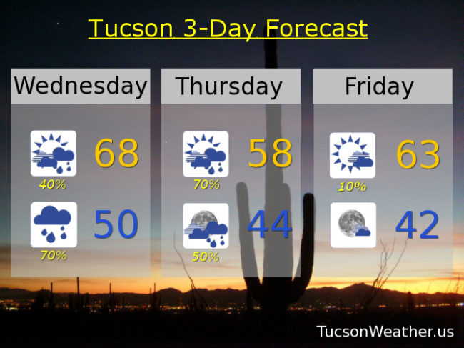
Our first storm will still be messing with us today with showers and gusty winds. SSW breezes gusting near 35 mph at times! Hold on to your hat, put rocks in your pockets, skirt alert, etc. Perhaps extra hairspray or gel as well. (do people still do that?) Only upper 60s this afternoon, so grab a jacket, preferably your own.
As our first storm departeth our second approacheth. This one is colder and will bring mountain snows down to 7,000 feet tonight. A couple few inches of snow for Summerhaven possible overnight with rain, heavy at times for bottom dwellers. Down near 50ish for a low,
Showers likely tomorrow with mountain snow. High only in the upper 50s. Showers continue tomorrow night with a low in the mid 40s.
Then our second storm leaves us and we think maybe it’s moving on just a little too easily. What about our need for rain and mountain snow? don’t you care?! (clears throat) Sorry. Where was I? Oh yeah. Clearing up Friday and the Sun returns to us! Low 60s by afternoon. Partly cloudy Friday night with a low in the low 40s Saturday morning. (mmm chili)
Mostly sunny Saturday upper 60s. Low 70s Sunday. Upper 60s Monday. Low 60s Tuesday. Will we see another storm next week. Stay tuned!