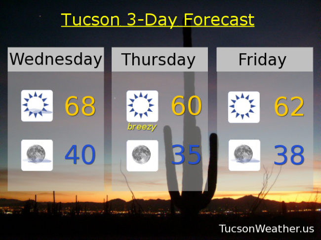
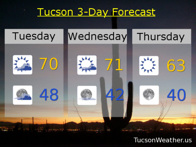
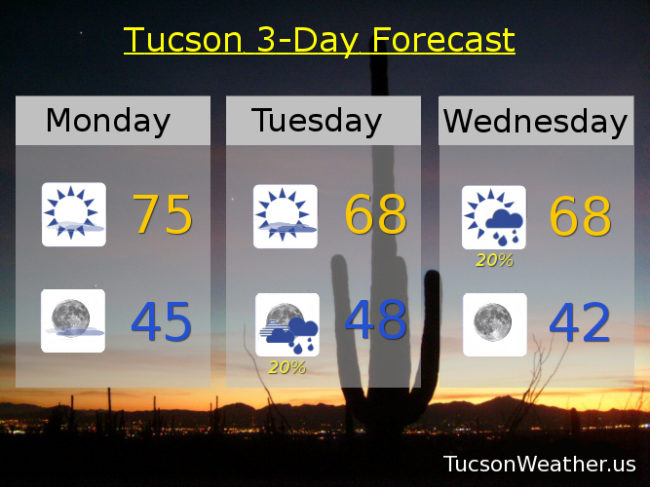
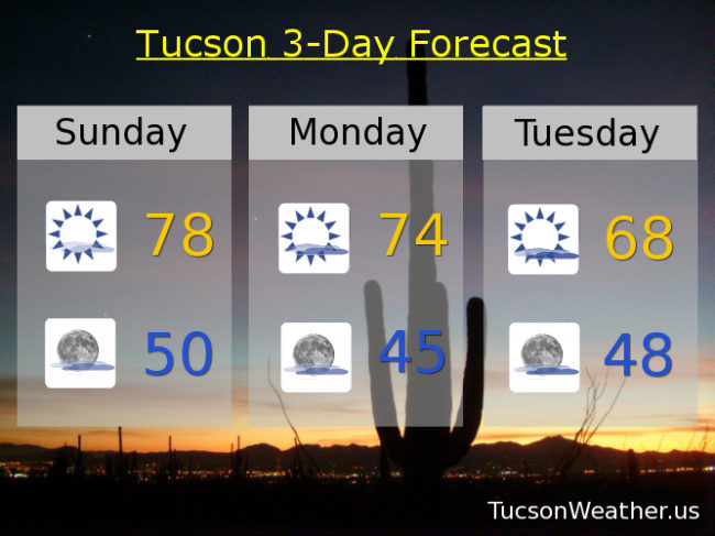
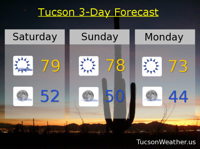
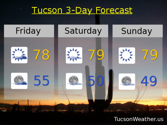
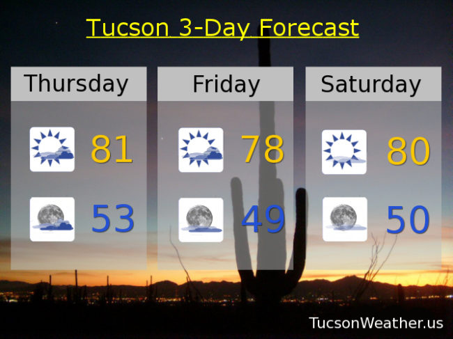
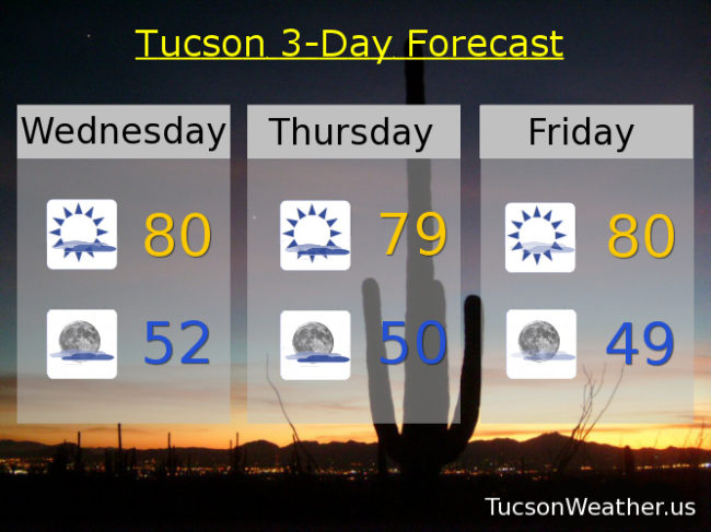
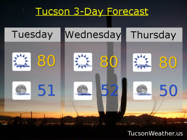
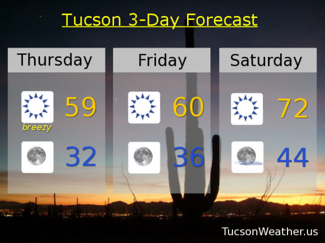
Now that’s the definition of rude awakening! Going outside on the deck for a cigar to be met with mid 40 temperatures and wind chills colder than that. I haven’t been that cold in a long time! Now I’m AWAKE! Gusty winds ushering in cold air today. ENE winds gusting to over 30 mph and a high only in the upper 50s. Parkas for sure for us thin blooded southern Arizonans. A RED FLAG WARNING has been issued and is in effect until 4:00 this afternoon so be careful if you are making a fire to stay warm, although I’m thinking your fireplace might be safe. The fun continues tonight as the winds die down and any remaining warmth escapes into space. A FREEZE WARNING has been issued and is in effect from 10:00 tonight until 9:00 tomorrow morning, so be warned, it’s gonna freeze. I would actually let the teenagers sleep inside tonight. Another chilly day tomorrow (mmm chili) with a high near 60, but it won’t feel as cold as today because sans the wind. Warming up this weekend with highs in the low 70s Saturday and mid 70s Sunday. Low 70s Monday. Mid 70s Tuesday and Wednesday.
Category Archives: Daily Forecast
Forecast for Wednesday, December 6, 2017
Pretty much a busted forecast in our favor yesterday. Instead of an expected high of 74 we only managed 63 and we did have some light rain showers in the area. (half the calories of our regular rain) The airport picked up .02″! Hey. Beats a swift kick. The low has moved east and has taken most of the clouds with it. Cool air behind the system is with us and a reinforcing shot of cool air tomorrow will keep us, well, on the cool side for the next several days. Look at those lows! 40 to start the day tomorrow. Mid 30s Friday morning! Upper 30s Saturday morning. Some of the favored cold spots, near washes for example, may see frost or a freeze even. Must be Winter. Warming up into the low 70s Saturday, Sunday, Monday and Tuesday. Enjoy!
Forecast for Tuesday, December 5, 2017
Rain chances are back out of the forecast. I’m still holding out a little hope that we may manage some showers since one of the computer models is hanging on to the possibility. The expectation was never more than a tenth of an inch anyway, but still. Even a few drops would be encouraging! A low over southern California is making its way to central Arizona today bringing clouds and a chance of rain for our local mountains by tonight and valley locations mainly to our east. Snow levels 7,000 – 8,000 feet by tomorrow morning, so mountains to the east could see a couple inches of snow above that, but nothing too serious. Once the storm weakens and moves east we will see clearing skies and colder air settling in. Low 60s for the high Thursday! Warming up as we head into the weekend with highs in the upper 60s Friday. Mid 70s Saturday and Sunday. Low 70s Monday. Lows as low as around 40ish Friday and Saturday morning.
Forecast for Monday, December 4, 2017
Last night’s Super Moon was spectacular! I don’t know if you saw it but at a couple points there was a ring around it thanks to the high clouds. The ice crystals in the high clouds refract the Suns rays being reflected off the Moon to cause the effect. Beautiful!
Meanwhile, we hit 78 again yesterday for the third day in a row. Today we start to cool things down. An upper low off the California coast is feeding us a few high clouds from time to time for possible sunrise and sunset enhancement. Otherwise mostly sunny today with a high near 75. A cool front moving through today will continue to knock our temperatures down even as our low approacheth. Increasing clouds tomorrow with a chance for rain showers Tuesday night into Wednesday morning. Nothing to get too excited about. Rainfall amounts are expected to remain below a tenth of an inch in valley locations. The low clears Wednesday taking the clouds with it but leaving the cool (average for this time of year) temperatures in the upper 60s Thursday and Friday. Lows near 40 Friday morning and in the upper 30s Saturday morning (also about average for this time of year). High pressure builds back in for a bit of a warm up for the weekend. Highs in the low 70s Saturday and Sunday. Enjoy!
Forecast for Sunday, December 3, 2017
Our southern disturbance in the force has moved east into far west Texas and has taken the clouds with it. That leaves us with a sunny day most of the day, but a few more clouds will be moving in the afternoon as a northern storm approacheth from the Great Basin on its way to the Four Corners. (that was one sentence!) This will also give us a cooling trend tomorrow into Tuesday. The southern jet stream will become more active with another disturbance headed our way Tuesday into Wednesday with more clouds and yes, a slight chance of rain, Tuesday night into early Wednesday! The computer models aren’t in agreement on this, but are trending that direction, so maybe some showers in our somewhat near future. Then again maybe not. We’ll have more information as we get closer. What is more certain is gusty east northeast winds at times Wednesday into Friday. Lows pretty low Friday and Saturday morning in the upper 30s to low 40s. Stay tuned!
Mostly sunny today with a high near 78.
Partly cloudy tonight with a low near 50.
Mostly sunny tomorrow with a high in the mid 70s. Partly sunny Tuesday with a high in the upper 60s. A slight chance for showers Tuesday night into Wednesday morning with a high in the upper 60s. Sunny Thursday upper 60s. Low 70s Friday. Mid 70s Saturday.
Forecast for Saturday, December 2, 2017
High clouds already thinning some this morning, but we are still looking at another mostly cloudy day. Clearing from the west by tonight if not sooner leaving us with lots of sunshine Sunday and beyond. Our next system will miss us to the north but will drive temperatures down to near average on Tuesday and then slightly warmer the rest of next week. As I pointed out yesterday, lows will be somewhat chill (mmm chili) starting Tuesday morning with lows in the mid to low 40s. Upper 30s Friday morning. Enjoy!
Mostly cloudy today with some sunshine and a high in the upper 70s.
Partly cloudy tonight with a low in the low 50s.
Sunny tomorrow with a high near 78ish. Low 70s Monday. Upper 60s Tuesday. Low 70s Wednesday, Thursday and Friday.
Forecast for Friday, December 1, 2017
Welcome to December! Only 25 days until Christmas! It’s beginning to look like Christmas too. With all the cloud cover the last two days you could enjoy a nice cup of coffee and pretend it’s 45 degrees outside because it looks like it could be! Of course the delusion is shattered once you venture out, but hey, it’s a fun exercise. The cloud cover will stick around another day with an upper level low off the Baja California coast and plenty of mid and upper level moisture streaming our way. Really dry at the surface so don’t expect any rain or even sprinkles from these clouds. Mostly sunny tomorrow and sunny Sunday as the low and clouds clear. Highs staying in the upper 70s to near 80. Then a second colder system moves our way. Still no rain expected but cooler temperatures. Mid 70s Monday. Mid 60s Tuesday. Upper 60s Wednesday. Near 70 Thursday. Lows getting chilly (mmm chili) with upper 30s to near 40 to start the day on Wednesday and Thursday. Enjoy!
Forecast for Thursday, November 30, 2017
Last day of November. Wow! What a long strange trip it’s been. Most likely the hottest on record, but let’s not dwell on the past. A new month is coming and that means new beginnings! Our considerable high cloudiness will remain considerable today and tomorrow and with a weak system tracking through Sonora, Mexico we may squeeze out a few sprinkles today and tonight! Pretty exciting, I know. Temperatures remaining in the upper 70s to near 80 through Sunday. Sunny on Monday with a high in the mid 70s. Then a storm missing just to the north MAY give us a chance for rain and WILL bring more cooling. Upper 60s Tuesday and Wednesday. Enjoy!
Forecast for Wednesday, November 29, 2017
77 yesterday a full 15 degrees lower than Monday and STILL 8 degrees above the average of 69 for this time of year. No worries. Looks like I will make it through the entire month of November without using the AC or the heat. Sorry TEP. Maybe next month. An upper low is forming off the California coast and is responsible for the considerable high cloudiness streaming across southern Arizona last night through tomorrow. Temperatures remain about the same (upper 70s to near 80) until the low makes its move this weekend until next week. Then we’ll see cooler temperatures and a slight chance for showers. The showers are in and out of the official forecast while the computer models get their act together. We’ll just have to stay tuned!
Partly sunny today with a high near 80.
Mostly cloudy tonight with a low in the low 50s.
Mostly cloudy Thursday upper 70s. Mostly sunny Friday near 80ish. Sunny Saturday near 80. Mostly sunny Sunday upper 70s. Partly sunny Monday low 70s. Upper 60s Tuesday.
Forecast for Tuesday, November 28, 2017
Whew! Glad that’s over! Change is here and change is good. Storm track to our north will continue to move farther south as we go through the week bring a mixture of clouds and sun for possible sunrise and sunset enhancement. Cooler temperatures too. Finally! A slight chance of rain this weekend into next week with temperatures finally near average by Monday. We’ll know more as we get closer. Stay tuned!
Increasing clouds today with a high near 80.
Partly cloudy tonight with a low in the low 50s.
Mostly sunny tomorrow with a high near 80ish. Partly sunny Thursday near 80. Sunny Friday near 80. Mostly sunny Saturday low 80s. Slight chance for showers Sunday mid 70s. Mostly sunny Monday upper 60s!