Category Archives: Daily Forecast

Forecast for Tuesday, September 12, 2017

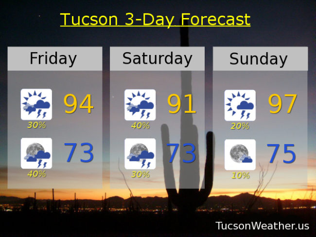
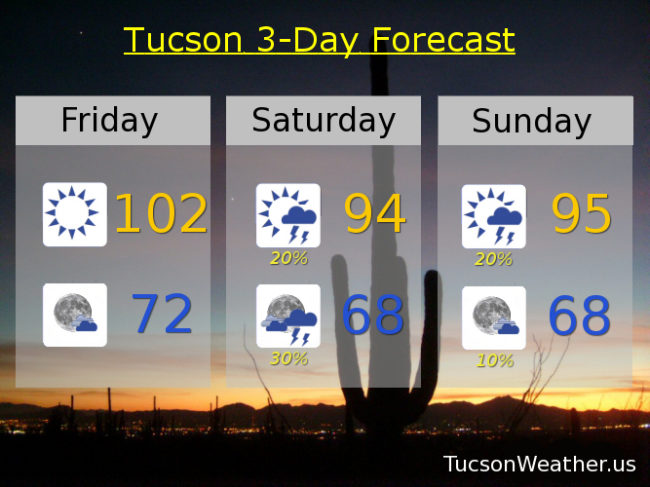
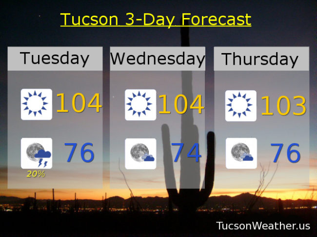
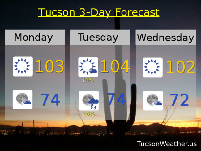
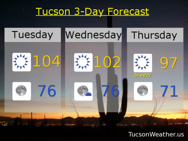
Who turned up the heat?! High pressure building back into Arizona will bring record heat to Tucson. It’ll be close at least. If the forecast comes exactly true we will miss the record of 105 set in 1943 by just a degree. Winds of change are coming and cooler air with it. A trough of low pressure moving through the Great Basin will kick up the winds Thursday and usher in “cooler” air with highs in the mid 90s to end the week and start the weekend. Our average high for this time of year is 96, so it will be nice to be average. The slightest chance of showers Sunday and Monday as Monsoon 2017 is all but finished.

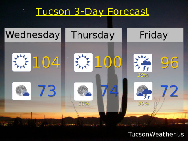
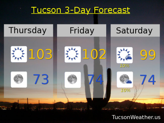
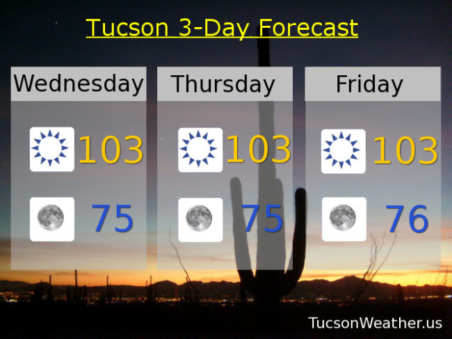
Sunny today with a high near 104.

Clear skies tonight with a low in the mid 70s.

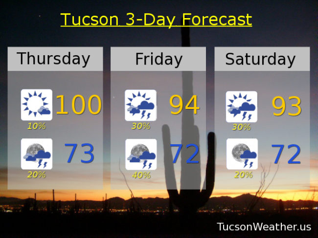
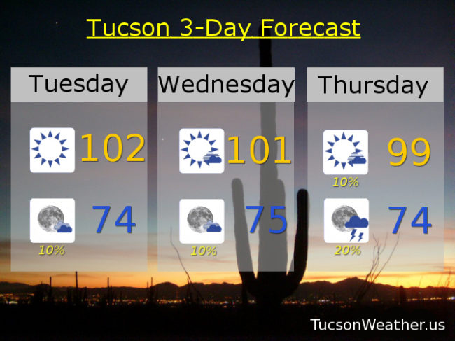
Sunny 102ish tomorrow. Breezy Thursday with SW winds gusting to around 30 mph by afternoon and a high in the upper 90s. Sunny Friday and Saturday near 94. A 10% chance for storms Sunday and Monday mid 90s.

Forecast for Friday, September 8, 2017

It’s Friiiidaaay! Monsoon 2017’s last hurrah? Maybe. Looking good for storms this afternoon through tomorrow. Moisture increasing from the south with a disturbance in the force helping to fire and organize storms this afternoon and tonight. Some of the storms could be on the strong side from Tucson west. Maybe some blowing dust to deal with with later today as well. Storm chances continue tomorrow and linger into Sunday before we dry out again next week. Viva Monsoon 2017!

Becoming partly sunny today with scattered afternoon storms and a high in the mid 90s.

Scattered storms tonight with a low in the low 70s.

Scattered storms tomorrow with a high in the low 90s. Isolated storms possible Sunday with a high in the upper 90s. Sunny near 100ish Monday and Tuesday. 99 Wednesday. 97 Thursday.

Forecast for Thursday, September 7, 2017

Storms are back in the forecast! Perhaps Monsoon 2017 isn’t quite done with us yet. Hazy sunshine with smoke from the fires in the Pacific Northwest still with us! As the high pressure moves into New Mexico and Texas that will open the door for a surge of moisture with scattered storms in the forecast as early as tonight with the best chances tomorrow and lingering into Saturday. Highs are going down the next couple of days as the moisture and cloud cover goes up. Drier air works back in starting Sunday into next week with highs back near 100.

Slight chance of an afternoon storm today otherwise becoming partly cloudy with a high near 100.

A chance of a storm or two tonight, hopefully near you, with a low in the low 70s.

Partly sunny tomorrow and Saturday with scattered afternoon and evening storms and highs near 94 and 93 respectively.

Just a 10% chance for a storm Sunday and a high near 98. Sunny Monday through Wednesday with highs near 101, 100 and 99.

Forecast for Wednesday, September 6, 2017

105 yesterday was only 2 degrees away from the record and today will be on the hot side as well with an expected high this afternoon near 104 under hazy sunshine. Moisture increases Friday and Saturday as high pressure currently over the Great Basin moves into New Mexico. Scattered storms return for those two days before we dry out again Sunday into next week.

High this afternoon near 104ish. Near 100 tomorrow. Mid 90s Friday and Saturday. 99 Sunday. 101 Monday and Tuesday.

Forecast for Tuesday, September 5, 2017

Welcome to Fall as the Labor Day Weekend is now behind us. Monsoon 2017 is sputtering to a close, but still a little moisture around for an evening storm or two, hopefully near you, the next couple of nights. High pressure to our north makes a slight jog to the east for a slightly better chance for storms Friday and Saturday. A SW flow dries us out again Sunday into next week.

Highs near 102ish today. 101 tomorrow. 99 Thursday. Mid 90s Friday and Saturday. 97 Sunday. Near 100 Monday.

Forecast for Friday, September 1, 2017

Here comes Lidia! Well, moisture from Lidia at least. Dewpoints are already in the mid 70s in Yuma from the moisture surge as Tropical Storm Lidia rakes across the Baja California peninsula. The better chance for storms will be tomorrow night from Tucson westward, so we went from “so you’re saying there’s a chance” yesterday to scattered storms in the forecast today. We’ll see how it plays out. Lingering storm chances Sunday before we dry out again next week. A slight chance for storms returns Tuesday through Thursday.

Sunny and warm today with a high near 102.

Mostly clear skies tonight with a low near 72.

Scattered storms possible tomorrow afternoon and night with a high in the mid 90s. Lingering storm chances Sunday with a high in the mid 90s. Mostly sunny Labor Day near 101ish. 20% chance for storms Tuesday 101. 10% chance Wednesday 99. 20% Tuesday 98.

Forecast for Thursday, August 31, 2017

Last day of August looks on the dry and warm side, but some subtle changes on the way for the Labor Day Weekend. High pressure in control right now with dry air will give way to more of a southerly flow by the weekend. Moisture from Tropical Storm Lidia may move for enough north to enhance or slight chance for storms slightly. Chance of rain Saturday through Wednesday still at only 10% but you are saying there’s a chance?! Highs today and tomorrow near 102 – 103. Saturday through Wednesday in the upper 90s. Enjoy!