Category Archives: Daily Forecast

Forecast for Saturday, August 26, 2017

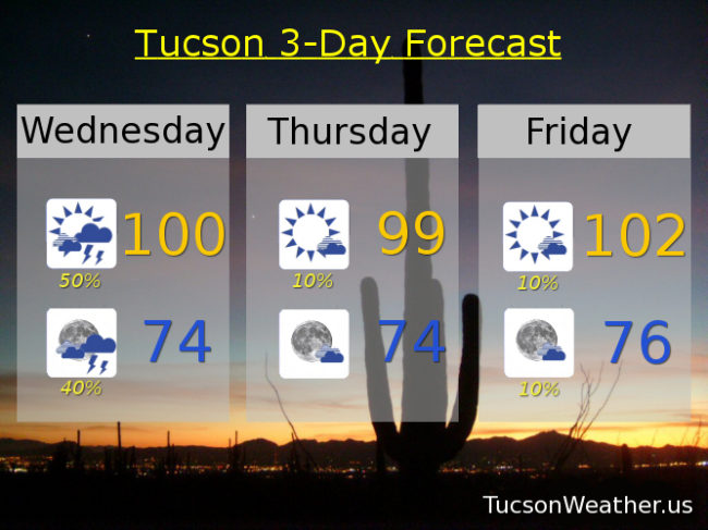
An isolated storm over Oro Valley yesterday was nice, but for the most part few and far between. Kinda like that again today with a chance that a few storms in the White Mountains may find there way our way by this evening. Low storm chances into next week with highs around 100ish.

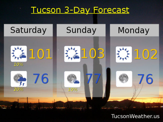
Mostly sunny today with a high near 101 and a slight chance of a storm.

20% chance of storms tonight with a low in the mid 70s.

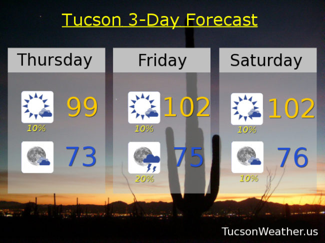
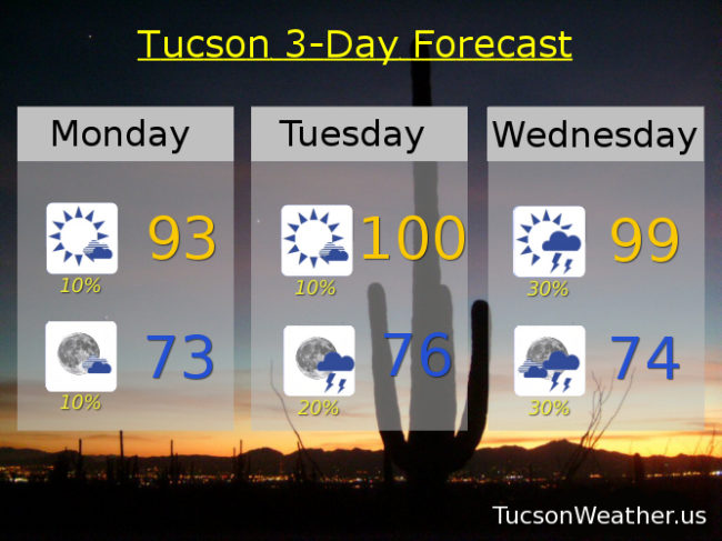
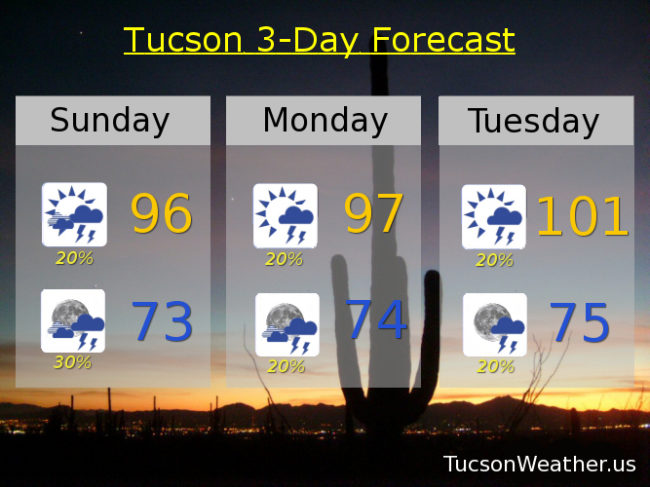
Mostly sunny tomorrow near 103. Sunny 102ish Monday. 10% chance for storms Tuesday and Wednesday near 100. Sunny near 100 Thursday. 10% chance for a storm Friday near 99.

Forecast for Friday, August 25, 2017

High pressure over northern Arizona and the Great Basin. Normally during Monsoon that would mean storms forming in the White Mountains would move off the Mogollon Rim and come get us. Unfortunately the moisture just isn’t there today for that. Looking slightly better for tomorrow so we’ll see. Otherwise low grade Monsoon continues with temperatures a few degrees above average for this time of year.

Sunny today near 100.

Slight chance of an isolated storm maybe with a low in the mid 70s.

20% chance of afternoon and evening storms tomorrow near 100. 10% chance for storms Sunday, Monday, Tuesday and Wednesday with highs near 101, 100, 100 and 100 respectively. Sunny Thursday with a high near 100ish.

Forecast for Thursday, August 24, 2017

A nice steady light to moderate rain yesterday over the area. I could have used a downpour but I’ll take it. It was nice. Refreshingly cool again this morning. We are settling into a “low grade” Monsoon pattern which means storms few and far between, but still a slight chance of a storm near you. Enjoy!

Mostly sunny today with a slight chance of a storm and a high near 99.

Partly cloudy tonight with a low in the low 70s.

Slight chance of an isolated storm tomorrow, Saturday and Sunday 102. Slight chance for a storm Monday 101. Slight chance for a storm Tuesday and Wednesday near 100ish.

Forecast for Wednesday, August 23, 2017

Monsoon 2017 is baaaaack! Just for a day visit, but if the forecast comes true it could be an active day. High pressure to our east and weak low pressure to our west should funnel moisture, and a disturbance in the force, our way for a good chance at numerous storms this afternoon and evening. Blowing dust may result NW of town so be aware if you are heading that way this evening. Storm chances continue into the night tonight before finally clearing up by tomorrow morning. Then slight storms chances Thursday into early next week. Viva Monsoon 2017!

Becoming partly sunny today with a good chance for storms and a high near 100.

Mostly cloudy tonight with a good chance for storms and a low in the mid 70s.

Just a 10% chance for storms Thursday through Monday with highs of 99, 102, 103, 103, and 102 respectively. 20% chance for storms Tuesday 101.

Forecast for Tuesday, August 22, 2017

Kinda hot today, but a SE flow will bring us moisture and a decent shot at scattered storms tomorrow afternoon into Thursday morning. After that storm chances get depressed again. It seems like Monsoon 2017 may be winding down early even though we have a month to go. Even if that is the case it’s been an amazing year as evidenced by how green and overgrown everything is. If we can get another downpour or two before the season ends, I am good!

Sunny near 103 this afternoon.

Partly cloudy tonight with a low near 75.

Scattered storms tomorrow afternoon and evening with a high near 98. A slight chance of an isolated storm Thursday (let’s be real, it ain’t gonna happen) with a high near 99. Mostly sunny Friday 99. 102 Saturday and Sunday. 10% chance of a storm Monday 102.

Forecast for Monday, August 21, 2017

Happy National Eclipse Day! or maybe, Everyone Goes Blind Day. You’ve heard all the warnings about looking directly at the Sun, so I figure you are a smart enough to handle your business. Great viewing weather with 59% of the Sun being eaten by a dragon at 10:36 this morning. The devouring starts at 10:19 so get your legit solar glasses ready or your DIY pinhole contraptions. Weatherwise, we have a SW flow aloft and therefore not enough moisture for a bunch of storms. Just a 10% chance of an isolated storm. So you’re saying there’s a chance! No. No I’m not. Skunksville until Wednesday and Thursday when winds come around to the SE. (they are bound to come around at some point) Enjoy!

Mostly sunny with a slight chance for an isolated storm and a high in the low 90s.

Mostly clear tonight with an isolated storm barely possible and a low in the low 70s.

Mostly tomorrow with a 10% chance of a storm and a high near 100. Scattered storms Wednesday and Thursday with highs in the upper 90s. 10% chance for storms Friday 100. 20% chance for storms Saturday and Sunday 101.

Forecast for Sunday, August 20, 2017

Will it or won’t it? Conditions seem favorable for a few storms out and about today, but are they? Computer models say yes and no, depending. Low pressure off the southern California coast. High pressure in south Texas. Both feeding moisture our way. Add a disturbance in Mexico and it sounds like a decent recipe for thunderstorm success. Mitigating factors seem to be the cloud cover which will inhibit surface heating and maybe that disturbance influences storm chances more to our south and east than in Metro Tucson. We’ll know more tomorrow! Stay tuned.

Partly sunny today with a chance for a storm or two hopefully near you and a high near 96.

Mostly cloudy tonight with a few storms about and  low in the low 70s.

Mostly sunny tomorrow with a chance for a storm or two near you and a high in the upper 90s. 20% chance for storms Tuesday 101. 30% chance for storms Wednesday 99. 30% chance for storms Thursday 98. 10% chance for storms Friday 99. Mostly sunny Saturday 100.

Forecast for Friday, August 18, 2017

Moisture working its way back our way for an increase in storm chances especially Sunday and Monday. A little uncertainty about next week on how well we will hold on the storm chances so we’ll just plug in your average approaching the end of August weather and see what happens! Stay tuned.

Sunny today with a high near 100.

Clear skies tonight with a low in the mid 70s.

Partly cloudy tomorrow with a slight chance for a storm and a high in the mid 90s. Scattered storms possible Sunday and Monday with a high in the mid 90s. 20% chance for storms Tuesday 96. 10% chance for storms Wednesday 96. 20% chance for storms Thursday 98.

Forecast for Thursday, August 17, 2017

Dry westerly flow still in control. Refreshingly cool mornings reminiscent of Fall! But Monsoon 2017 ain’t dead yet. Southerly winds will transport moisture our way from Mexico by this weekend for a chance at scattered storms into next week. Stay tuned!

Sunny today with a high near 99.

Clear skies tonight with a low in the low 70s.

Sunny near 100ish tomorrow. Slight chance of a storm Saturday upper 90s. 30% chance of storms Sunday upper 90s. 20% chance of storms Monday and Tuesday mid 90s. Slight chance of storms Wednesday mid 90s.

Forecast for Wednesday, August 16, 2017

It is amazing right now on the deck! What a refreshingly cool start to the morning. That’s what dry air will do for you. A trough to our north keeping us in a dry westerly flow through Friday and at the same time keeping our highs from getting too crazy. If Monsoon insists on taking a break, this is the recommended way to do it. Moisture will return this weekend with storms back in the forecast as early as Saturday night. Stay tuned!

Sunny and seasonably warm with a high in the upper 90s.

Clear skies tonight with a low near 69.

Sunny near 99 tomorrow. 100ish Friday and Saturday. 20% chance of storms Sunday 96. 40% chance of storms Monday 95. 20% chance of storms Tuesday 95.