Category Archives: Daily Forecast

Forecast for Tuesday, August 15, 2017

Drying out with highs around average to a few degrees above and refreshingly cool mornings. Moisture returns this weekend for a renewed chance for showers and storms into next week. Viva Monsoon 2017!

Sunny today with a high near 99.

Clear skies tonight with a low in the low 70s.

Sunny upper 90s tomorrow and Thursday. Near 100ish Friday. Slight chance of a storm Saturday near 100. 20% chance of storms Sunday upper 90s. 20% chance of storms Monday mid 90s.

Forecast for Monday, August 14, 2017

Just a slight chance of a storm today as we start to dry out. A westerly flow will shut off Monsoon 2017 for the work week with storm chances returning this weekend. Highs around average for this time of year and a bit above average toward the end of the week. Lows refreshingly cool.

Mostly sunny today with a slight chance of a storm and high in the upper 90s.

Mostly clear tonight with a low in the mid 70s.

Sunny upper 90s Tuesday and Wednesday. Near 100ish Thursday. 101 Friday. 100 Saturday. Slight chance of storms Sunday 98.

Forecast for Sunday, August 13, 2017

Oh what a night! Over an inch of rain at the airport starting just after 2am this morning. Kind of the opposite of rude awakening. It was epic! The atmosphere is kind of rained out this morning so storms may be late on the scene this afternoon. We are still expecting scattered storms, some with locally heavy rain. After our upper low clears the area we are looking at a dry westerly flow for the rest of the week into the weekend. Lots of Sun and a bit warmer. Viva Monsoon!

Partly sunny today with scattered late afternoon storms and a high near 98.

Mostly cloudy tonight with scattered storms and a low near 75.

Mostly sunny tomorrow with a slight chance of a storm upper 90s. Sunny Tuesday and Wednesday 98ish. 99 Thursday. Near 100 Friday and Saturday.

Forecast for Saturday, August 12, 2017

Get ready for a fun Monsoon weekend assuming this all comes true. A weak upper level low in the Gulf of California is moving our way and will be moving through this weekend. Combined with plenty of moisture we should see scattered to numerous storms, some with locally heavy rain. A westerly flow sets up next week and we should dry out for another Monsoon 2017 break. Hopefully we make hay while the Sun shines, er, um, hopefully we’ll be singing in the rain before we make hay next week. As always, enjoy Monsoon 2017 responsibly.

Partly sunny today with scattered showers and storms and a high near 99.

Mostly cloudy tonight with scattered storms and a low near 75.

Mostly cloudy tomorrow with scattered to numerous storms and a high near 96. Chance for storms Monday 98. Sunny Tuesday and Wednesday 98. 99 Thursday. Near 100 Friday.

Forecast for Friday, August 11, 2017

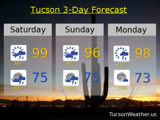
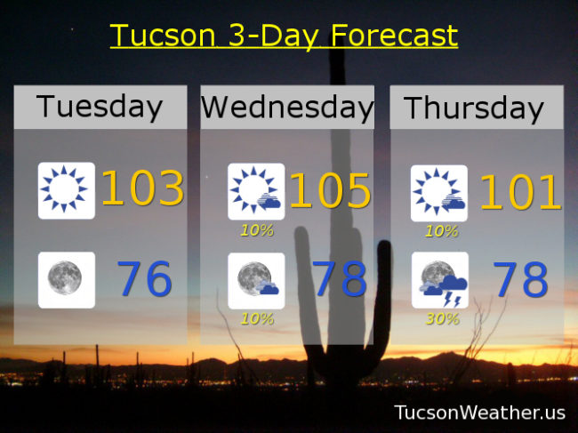
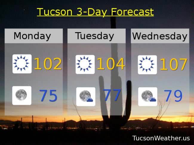
What a day yesterday! When Monsoon 2017 decides to make a come back it doesn’t mess around. Only .11″ at the airport, but most picking up more and some much more! Looks like a down day today with a low in Baja California moving north actually putting us in an area of sinking air. Storms will struggle to form across the Metro. Still a chance for one or two, hopefully near you, with scattered storms tonight. This weekend looks active with storm chances increasing from 30% tomorrow to 50% by Sunday night. Scattered storms Monday too. A westerly flow setting up bring drier air, less storms, and warmer highs starting Tuesday. Enjoy!

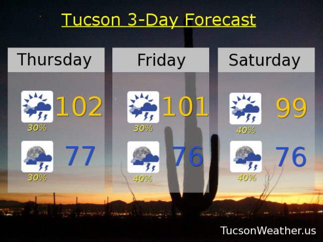
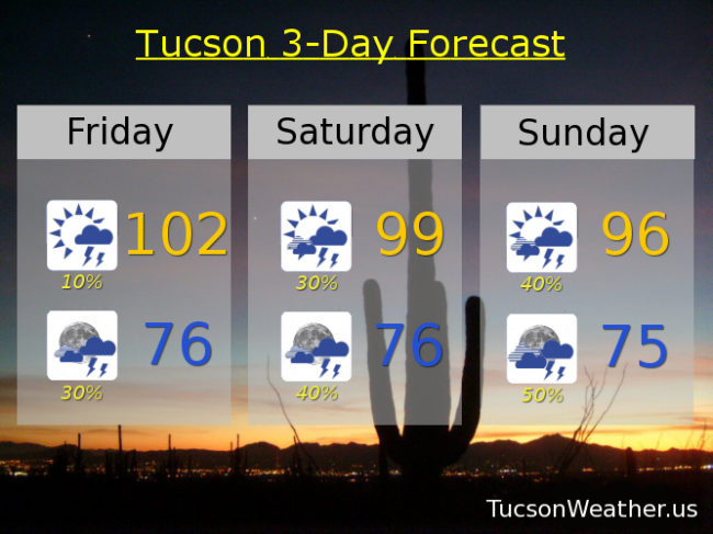
Mostly sunny today with a slight chance for an isolated storm or two and a high near 102.

Mostly cloudy tonight with scattered storms and a low near 76.

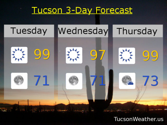
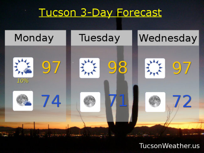
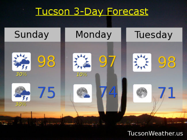
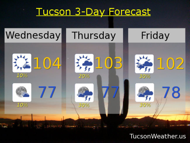
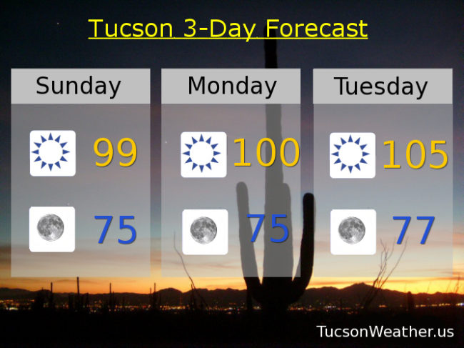
Scattered to numerous storms this weekend with highs near 99 and 96 respectively. 20% chance of storms Monday 97. 10% Tuesday and Wednesday 98 and 99. Mostly sunny 100 Thursday.

Forecast for Thursday, August 10, 2017

Monsoon 2017 is back!!! A few showers around yesterday and I woke up to a bit of light rain (half the calories of our regular rain) on the deck this morning. High pressure is now centered in Texas. The moisture has returned and a couple of disturbances in the force riding north will help trigger scattered storms this afternoon and evening. This weekend looks the most active for storms with storm chances decreasing, but still continuing into next week. Viva Monsoon 2017!

Becoming partly cloudy today with scattered afternoon and evening storms and a high near 102.

Scattered storms tonight with a low in the upper 70s.

Scattered storms tomorrow 101ish. Scattered storms Saturday 99. 50% chance of storms Sunday 96. 20% chance of storms Monday 96. 20% chance of storms Tuesday 98. 10% chance Wednesday 99.

Forecast for Wednesday, August 9, 2017

Still on the hot side for a few more days, but good news is on the southern horizon Monsoon lovers! A huge thunderstorm complex overnight in Mexico has pushed moisture our way giving our border areas a chance for scattered storms this afternoon and evening (I’m looking at you Santa Cruz County). An isolated storm or two is possible for the Metro, hopefully near you. Storm chances continue to ramp up as we head toward the weekend with scattered to numerous storms possible Saturday and Sunday and maybe we’ll even bring back the locally heavy rainfall. Viva Monsoon 2017!

Mostly sunny today with a slight chance of a storm or two and a high near 104.

An isolated storm possible this evening otherwise partly cloudy tonight with a low near 77.

Widely scattered storms tomorrow near 103. Scattered storms possible Friday 102ish. 40% chance of storms Saturday near 100. 50% chance for storms Sunday 94. 30% Monday 94. 20% Tuesday 95.

Forecast for Tuesday, August 8, 2017

Refreshingly cool this morning with a couple of hot dry days left in the forecast. That’s because Monsoon 2017’s break is fixin to come to an end! Moisture increasing as early as tomorrow with a slight chance of a storm, hopefully near you. “Things” really ramp up this weekend as Tropical Storm Franklin located all the way over by the Yucatan Peninsula will continue west into northern Mexico enhancing our moisture as it’s remnants pass to our south. Viva Monsoon  2017!

Sunny today with a high near 103.

Clear skies tonight with a low in the mid 70s.

Mostly sunny tomorrow with a slight chance of a storm and a high near 105. Slight chance of a storm Thursday near 101ish. 30% chance of storms Friday 101. 40% chance of storms Saturday 97. 30% chance of storms Sunday and Monday mid 90s.

Forecast for Monday, August 7, 2017

High pressure firmly in control with a dry westerly flow. Highs soaring the next few days with nuthin’ but Sun to light our way. High pressure moves east by weeks end and thunderstorms once again will begin. An easterly wave to enhance our chances with Saturday soakers answering rain dances. Enjoy the heat if that’s your thing. Monsoon 2017 soon returns with the storms it will bring!

Sunny today with a high near 102.

Clear skies tonight with a low in the mid 70s.

Sunny and hot tomorrow with a high near 104ish. Hotter Wednesday near 107. 10% chance of a storm Thursday near 103. 20% chance of storms Friday 103. 40% chance of storms Saturday 97. 30% chance of storms 96 Sunday.

Forecast for Sunday, August 6, 2017

Still drying out and heating up. Moisture begins to return Wednesday, but the best storm chances won’t be back until the weekend. Kinda hot too with Tuesday and Wednesday 105-107ish. No worries. Monsoon 2017 hasn’t abandoned us yet!

Sunny today with a high near 99.

Clear skies tonight with a low in the mid 70s.

Near 100 tomorrow. 105ish Tuesday. 107 Wednesday. 10% chance for storms Thursday 104. 20% chance Friday 103. 40% Saturday 101.