Category Archives: Daily Forecast

Forecast for Saturday, August 5, 2017

I’m not sure who approved Monsoon 2017’s vacation request, but it’s taking the week off. Our old pal high pressure will be building in bringing the heat back to Tucson’s Weather. By the end of the week the high moves east opening the door for the moisture to return along with scattered storms. Be cool!

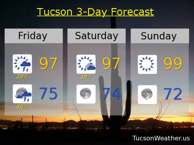
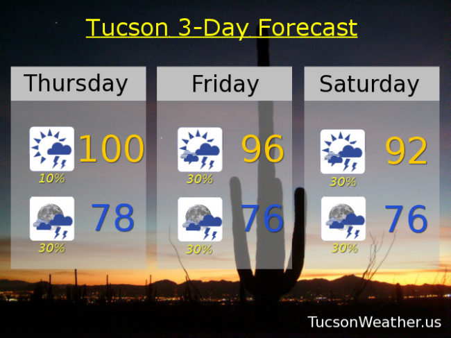
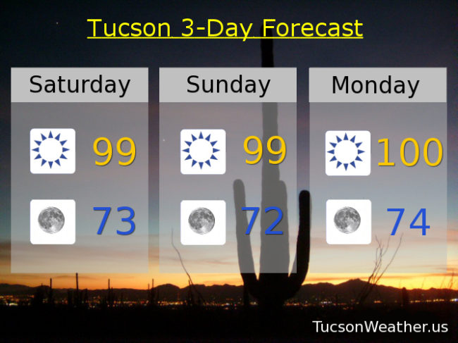
Sunny today with a high near 99.

Clear skies tonight with refreshingly cool low in the low 70s.

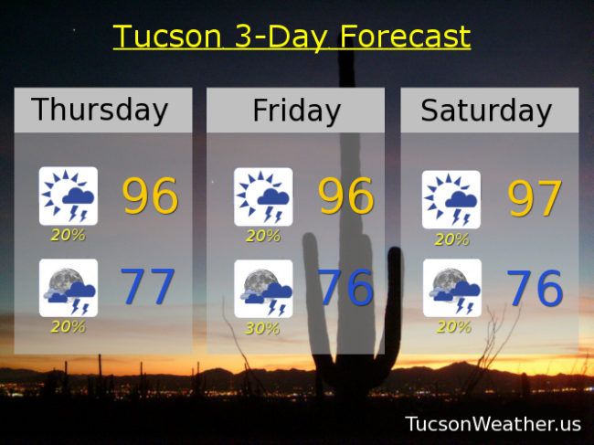
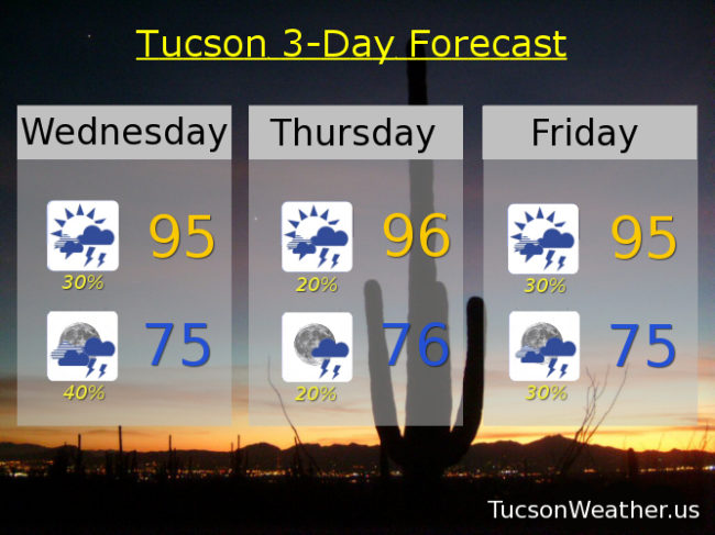
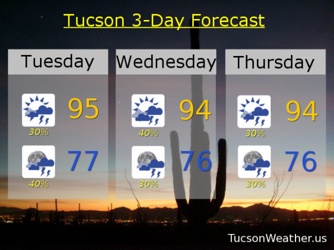
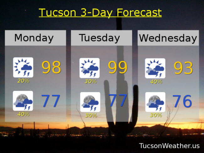
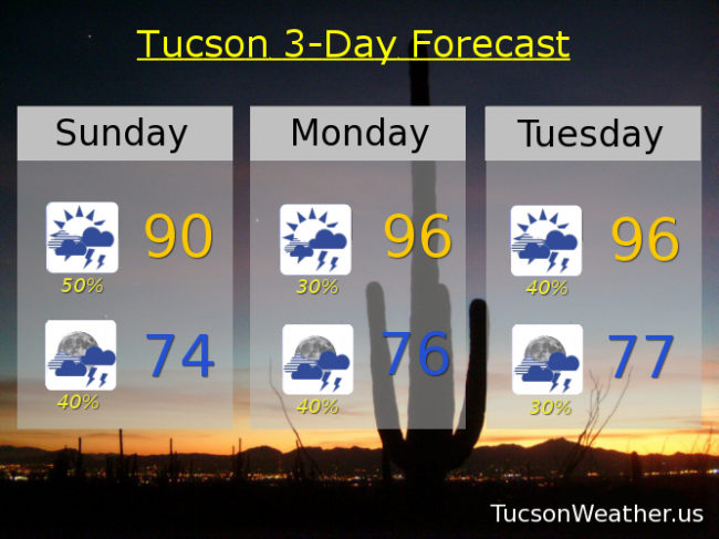
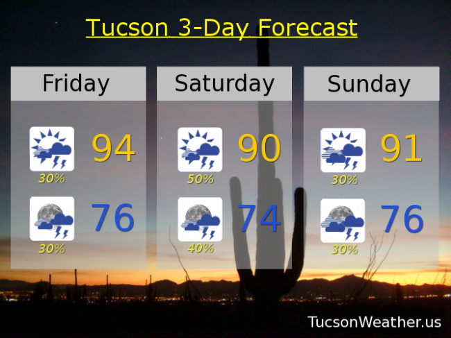
Sunny tomorrow near 99. 100ish Monday. 105 Tuesday. 107 Wednesday. Slight chance of an isolated storm Thursday 104. A storm or two Friday 103.

Forecast for Friday, August 4, 2017

It’s Friiidaay!

Parting is such sweet sorrow. Great rains for Marana and Pictures Rocks and other western locations last night after flooding rains yesterday afternoon on the south side. Today may be as active as yesterday or maybe not quite as we hold on to moisture one more day before the great Monsoon dry out of 2017. High pressure building to our west bring drier air tomorrow and then moving to our south keeping the moisture from returning. That reverses itself toward the end of next week for the great Monsoon 2017 come back! Until then and starting tomorrow it’s higher highs and refreshingly lower lows. Stay tuned!

Mostly sunny becoming partly sunny this afternoon with scattered storms and a high in the upper 90s.

Scattered storms tonight with a low in the mid 70s.

An isolated storm at best tomorrow with mostly sunny skies and a high in the upper 90s. Sunny upper 90s to near 100 Sunday. 100 Monday. 102ish Tuesday. Isolated storms Wednesday 103. Widely scattered storms Thursday near 100.

Forecast for Thursday, August 3, 2017

Moisture levels dropping but still scattered afternoon and evening storms in the forecast through Saturday. Then Monsoon 2017 takes a few days off Sunday into the middle of next week bringing lots of sunshine and 100 degree heat back in the forecast. Monsoon 2017 should return from a short vacation by Wednesday or Thursday with scattered storms back in the forecast.

Mostly sunny today with widely scattered storms this afternoon and evening and a high in the mid 90s.

Scattered storms tonight with a low in the upper 70s.

Mostly sunny with widely scattered afternoon and evening storms Friday and Saturday with highs in the mid to upper 90s. Slight chance of an isolated storms Sunday near 99. Mostly sunny Monday near 100. Slight chance of an isolated storm Tuesday 102. Widely scattered storms Wednesday 100.

Forecast for Wednesday, August 2, 2017

Pinal County the big winner for the second night in a row as a disturbance moving through Pima County helped storms to form on the northern edge. Hardly seems fair, but here we are. Another disturbance headed our direction from Mexico should give Santa Cruz County a good shot at storms today. Lots of moisture still around. (You probably noticed because you never actually completely dry off from your morning shower) Expect today to be more active than the last two with scattered storms today and tonight, some with heavy rainfall. A bit of a down day tomorrow but still an few storms around. Scattered storms Friday and Saturday before we dry out Sunday through Tuesday. Still isolated storms possible. Highs in the mid 90s and lows in the mid 70s through Sunday. Upper 90s Monday.  Near 100 Tuesday. Stay tuned!

Forecast for Tuesday, August 1, 2017

Monsoon 2017 keeps chugging along.  July ends with a record 6.80″ of rain.  Amazing!  The first week of August is set to continue the trend.  Lots of moisture still around.  Quite a bit of cloud cover from last night’s storms that missed most of us will delay afternoon heating.  A couple of disturbances moving in from the south should get us going by late afternoon and evening with scattered storms continuing tonight.  An upper low from Baja is scheduled to move across the area tomorrow with a good chance of storms as a result.  Scattered storms remain in the forecast through Saturday with the possibility that we may dry out starting Sunday into early next week.  Stay tuned!

Partly sunny today with scattered late afternoon and evening storms and a high near 95.

Mostly cloudy tonight with scattered storms and a low in the upper 70s.

Scattered storms tomorrow and tomorrow night through Saturday with highs in the mid 90s.  Mostly sunny with isolated storms Sunday and Monday with highs in the mid to upper 90s.

Forecast for Monday, July 31, 2017

Last day of July.  Gonna be sad to see it go.  Such an amazing ride!  We picked up another .01″ of rain at the airport yesterday so now the monthly record rainfall for July sits at 6.80″!  Remarkable.  Will we add to it today?  Maybe.  Lots of sunshine and moisture may lead to a storm or two popping up this afternoon.  The better chance will be after 5:00 when a disturbance rides out of Mexico and heads our way.  If this pans out our bast chance for storms will be this evening and tonight.  Scattered storms possible tomorrow to start August out right.  Then conditions for storms become more favorable Wednesday.  Daily scattered storms possible the rest of the week through the weekend.  Viva Monsoon 2017!

Mostly sunny today with a chance for an afternoon storm or two, hopefully near you, and a high in the upper 90s.

Mostly cloudy tonight with scattered storms and a low in the upper 70s.

Scattered storms possible tomorrow upper 90s.  Better chance of storms Wednesday with a high in the low 90s.  Chance of storms through Sunday with highs in the mid 90s.

Forecast for Sunday, July 30, 2017

Wow!  .87″ of rain yesterday at the airport.  July and Monsoon total now at 6.79″!  That is a record for July rainfall and surpasses our average total Monsoon rainfall of 6.08″.  Remarkable and we ain’t done yet!  An inverted trough is over the area today with disturbances riding through as well.  Tons of moisture in the air.  All that to say there is a good chance of storms today and tonight with locally heavy rainfall possible.  Scattered storms remain in the forecast until further notice.  Enjoy!

Partly sunny today with a good chance for storms and a high near 90.

Mostly cloudy tonight with scattered storms and a low near 74.

Partly sunny tomorrow with scattered storms and a high in the mid 90s.  Scattered storms through Saturday with highs in the mid 90s.

Forecast for Saturday, July 29, 2017

Amazing!  The airport picked up an inch and a third of rain yesterday.  We are now officially just barely shy of six inches of rain for July and Monsoon 2017.  The average for Monsoon is just above six inches.  We are basically there in one month!  Not everyone has had six inches of rain so far.  A few have had more and more have had less.  Still, all in all we are enjoying a nice soaking this month.  Looks like more of the same with an inverted trough (basically a low moving west instead of east) nosing into southern Arizona today giving us a decent chance at more activity today and tonight.  Scattered storms continue into next week.  Viva Monsoon!!!

Becoming partly sunny today with scattered afternoon and evening storms and a high near 90.

Mostly cloudy tonight with scattered storms and a low in the mid 70s.

Scattered storms through Friday with highs in the low to mid 90s.  Upper 90s Friday.

Forecast for Friday, July 28, 2017

It’s Friiiiidaaay!  Nice gentle light rain overnight after hitting 100 yesterday for the first time since July 15th.  We’ll start another streak of sub century days today as storm chances increase this weekend.  Some of the rains this weekend could be heavy!  Scattered storm chances remain through much of next week although we may dry out some by the end of the week.  Viva Monsoon 2017!

Partly sunny today with scattered afternoon and evening storms and a high near 94.

Mostly cloudy tonight with scattered storms and a low near 76.

Good chance for storms Saturday, some with heavy rainfall possible, and a high near 90.  Scattered storms Sunday through Thursday with highs in the low to mid 90s.

Forecast for Thursday, July 27, 2017

Another down day for storms yesterday although some mountain locations got wet.  High pressure will remain in the vicinity of northern New Mexico to the Texas panhandle into next week which should continue to increase our moisture from the south and southeast.  That means the return of scattered storms as early as late this afternoon into tonight and continuing into next week.  As the moisture increases we’ll see the threat of locally heavy rain come back into the picture.  If today’s forecast high comes true it will be the first 100 degree day since July 15th.  If we don’t make it, like we didn’t yesterday, then our “cool” streak will continue!  Our average high for this time of year is 98.  Viva Monsoon 2017!

Mostly sunny today with a slight chance of a storm near you and a high near 100.

Scattered storms possible tonight with a low near 78.

Scattered afternoon and evening storms continue into next week with highs in the mid to low 90s.  Upper 90s Tuesday and Wednesday.