Category Archives: Daily Forecast

Forecast for Wednesday, July 26, 2017

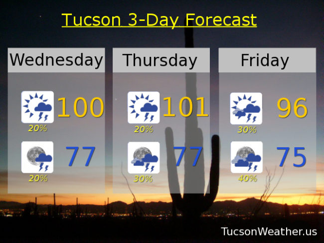
No rain across the area yesterday.  It’s been awhile since we could say that!  The good news is Monsoon 2017 is cutting its vacation short!  Moisture on the increase today and storm chances will be ramping up as we approach the weekend.  Friday afternoon into overnight Friday night/Saturday morning looks particularly interesting.  If the forecast comes true today’s high of 100 will be the first time we’ve hit 100 since July 15th!  There will be a few storms around this afternoon/evening as well.  Hopefully near you.  Viva Monsoon 2017!

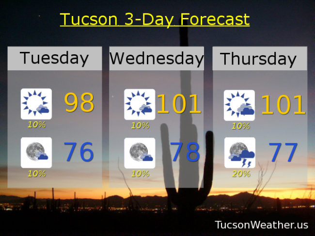
Mostly sunny today with a chance for afternoon storms and a high near 100.

Partly cloudy tonight with a chance for a few storms before midnight and a low in the upper 70s.

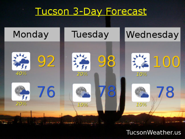
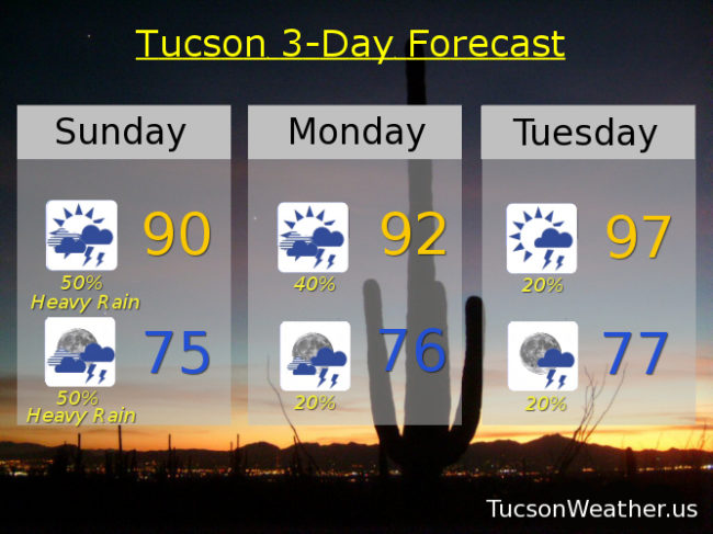
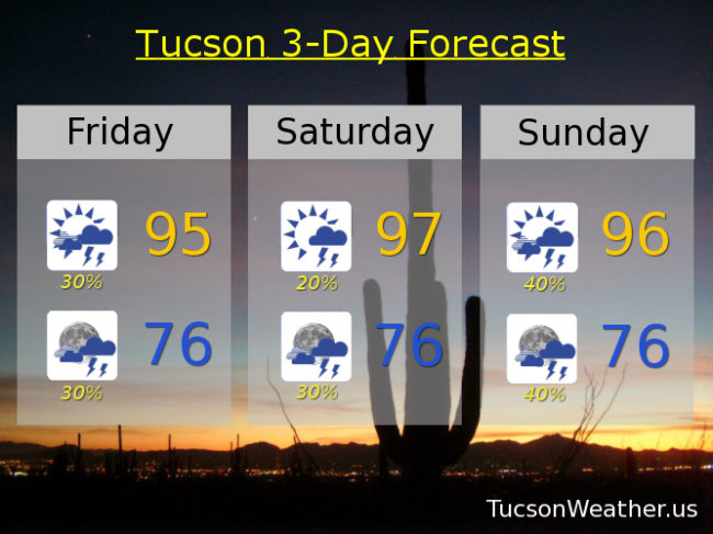
Mostly sunny tomorrow with a chance for afternoon and evening storms with a high near 101.  Scattered storms Friday, Saturday and Sunday with highs in the mid 90s.  A chance for storms Monday and Tuesday with highs in the upper 90s to near 100.

Forecast for Tuesday, July 25, 2017

Yesterday was the first July day not to hit 90 degrees since 2010!  A high of 88 and a half inch of rain at the airport.  Just lovely 🙂  Monsoon 2017 will be taking a much deserved break for a few days with drier air and higher highs today through Thursday.  Our Monsoon high then moves to northern Arizona giving us a SE flow and right back to more moisture and more storms.  Best Monsoon Evah!

Mostly sunny today with a slight chance of a storm or two, hopefully near you, and a high in the upper 90s.

Mostly clear tonight with a slight chance of a storm before midnight and a low in the mid 70s.

Slight chance of a storm or two Wednesday and Thursday with highs near 101.  Scattered afternoon and evening storms Friday through Monday with highs in the mid to upper 90s.  Enjoy!

Forecast for Monday, July 24, 2017

What a Monsoon!  The airport picked up another third of an inch yesterday.  We are now officially over 4 inches so far this month!  The average for the entire Monsoon is just over 6 inches so we are well on our way.  Our disturbance in the force is north of us today so best chances of rain will be to our north, but we still have plenty of moisture around for scattered storms this afternoon.  More of a southerly flow today so storms that do form will be moving to the north so the threat of heavy rain is somewhat diminished.  We start to dry out and subsequently warm up tomorrow into Thursday but still a storm or two, hopefully near you.  Moisture surges again Friday into the weekend with an uptick in storms expected.  Viva Monsoon 2017!

Partly sunny today with scattered afternoon and evening storms and a high in the low 90s.

Becoming partly cloudy tonight with a few storms before midnight and a low in the mid 70s.

Mostly sunny with isolated storms Tuesday, Wednesday and Thursday with highs near 98, 100 and 99 respectively.  Scattered storms possible Friday, Saturday and Sunday with highs near 97, 95 and 96.

Forecast for Sunday, July 23, 2017

Get ready for an interesting 24-36 hours.  Looks like an upper level low will be moving across the area today into tomorrow morning.  That should lead to pretty widespread heavy rainfall.  Worst case scenario we will have widespread flooding to go with it.  Confidence is pretty high that there will be some flooding rain in the area.  As a result of the clouds and rain potential we could see a high only in the upper 80s to near 90.  If we stay below 90 for a high today it will be the first July day below 90 since 2010.  Let’s make it happen!  Drying out quite a bit by Tuesday with less storm activity and warmer temperatures into next weekend.  Looks like the wetter weather returns next week!  Best Monsoon Evah!

Mostly cloudy today with showers and storms likely, some with heavy rain, and a high near 90.

Mostly cloudy tonight with showers and storms likely, some with heavy rain, and a low in the mid 70s.

Partly sunny tomorrow with scattered showers and storms and a high in the low 90s.

Partly cloudy Tuesday through Saturday with isolated storms and highs in the upper 90s.

Forecast for Friday, July 21, 2017

Viva Monsoon 2017!  Heavy rain and flooding for some last evening and a good soaking afterward for pretty much everyone.  Amazing Monsoon so far.  The good news is the rain chances continue!  Tons of moisture still around that should lead to round after round of scattered afternoon and evening storms.  Some with locally heavy rainfall even.  A hint in the computer models that we may dry out a bit by Tuesday into Wednesday.  We’ll see.  Until then may the refreshing rains muddy your path.

Scattered afternoon and evening storms today, some with heavy rainfall perhaps, and a high in the mid 90s.

Mostly cloudy tonight with scattered storms and a low in the mid 70s.

Mostly sunny tomorrow with a chance for afternoon and evening storms and a high in the upper 90s.

Scattered afternoon and evening storms Sunday and Monday with highs in the mid 90s.  A chance for storms Tuesday through Thursday with highs in the mid to upper 90s.

Forecast for Thursday, July 20, 2017

What a day yesterday!  Flooding for some.  Damage for others.  Others like the airport got nothing.  That’s the hit and miss nature of the Monsoon, but with rare exception, most have been getting hit after hit after hit!  The hits keep coming as all of your favorite showers and storms are cued up through the weekend.  Lots of moisture in place and an upper level low in far west Texas inching this way should keep us in the scattered to numerous storm chances through the weekend in to early next week.  We MAY dry out some Tuesday and Wednesday.  We’ll know more next Thursday.  Stay tuned!

Partly sunny today with scattered afternoon and evening storms and a high in the mid 90s.

Mostly cloudy tonight with scattered showers and storms and a low in the mid 70s.

More of the same Friday, Saturday, Sunday and Monday with highs near 95, 97, 96 and 95 respectively.  Storm chances go down a bit Tuesday and Wednesday with highs a bit higher in the upper 90s.

Forecast for Wednesday, July 19, 2017

Somebody pinch me.  Monsoon 2017 just keeps rockin’ along with copious amounts of moisture around leading to scattered to numerous showers and storms, some with locally heavy rainfall.  Below average temperatures too!  After June and early July we earned it!  Enjoy.

Partly sunny today with showers and storms likely this afternoon and evening with a high in the mid 90s.

Mostly cloudy with scattered storms tonight and a low in the mid 70s.

Scattered showers and storms Thursday through Tuesday with highs in the mid to upper 90s and lows in the mid 70s.

Forecast for Tuesday, July 18, 2017

The air remains extra juicy and that means any storms that form will have the potential for heavy rainfall and/or gusty winds.  Drying out a bit Thursday and Friday but still scattered storm chances.  Then ANOTHER upper low approacheth from the east and we’ll be back to this pattern that has busted Monsoon 2017 wide open!  Viva Monsoon 2017!!!

Scattered showers and storms this afternoon and evening, some with heavy rain possible and a high near 96.

Scattered showers and storms possible tonight, some with heavy rain possible and a low near 76.

Lather rinse and repeat tomorrow.

Scattered storms possible Thursday, Friday and Saturday with highs in the mid to upper 90s.  Scattered storms Sunday and Monday with locally heavy rain possible and highs in the mid 90s.

Forecast for Thursday, July 13, 2017

More scattered rain last night!  Although the airport got skunked where I am house sitting in the Foothills got another good soaking.  Great light show too!  Look for a repeat performance tonight.  An upper level low in far west Texas is slowly moving west.  As it gets closer we’ll see our SW flow continue and we’ll add more energy to the atmosphere.  That means storms forming this afternoon on the Mogollon Rim will make the drive to Tucson and give us more rain and an awesome light show tonight.  Some of the activity this afternoon and evening may be severe with some large hail and damaging winds perhaps.  Storm chances continue through the weekend and into next week with seasonable temperatures.  Viva Monsoon 2017!

Mostly sunny today with a slight chance of a storm or two this afternoon and a high near 99.

Mostly cloudy tonight with a good chance for storms and a low near 78.

Partly sunny tomorrow with scattered afternoon and evening storms possible with a high near 101.  Scattered storm chances continue through Wednesday of next week with highs near 101, 99, 98, 98 and 99 respectively.

Forecast for Wednesday, July 12, 2017

Another streak is broken.  Yesterday was the first time we didn’t hit 100 or above in 27 days!  Fantastic.  The other good news is the forecast.  Scattered storms into next week and perhaps beyond, hopefully near you.  A disturbance to our south approaching the Texas Big Bend should help to get storms firing by this evening.  Locally heavy rainfall possible with some of the storms.  Tomorrow may see a few severe storms, so there’s that.  Storm chances remain through the weekend and into next week.  Viva Monsoon 2017!

Mostly sunny today with a few storms possible this afternoon and a high in the upper 90s.

Mostly cloudy tonight with storms and a low in the mid 70s.

Scattered storms possible tomorrow through Tuesday with highs near 99, 102, 101, 99, 98 and 100 respectively.  Enjoy!