Category Archives: Daily Forecast

Forecast for Tuesday, July 11, 2017

It was a long time coming.  We suffered through an epic heatwave and even the prickly pear were suffering under the scorching arid Sun.  Last night was our reward!  The big payoff!  Pretty much everyone got soaked and the desert took a long much needed drink.  .69″ storm total at the airport and many got more!  The good news is the pattern continues.  Tons of moisture in place with scattered storms and seasonable temperatures through the weekend.  Viva Monsoon 2017!

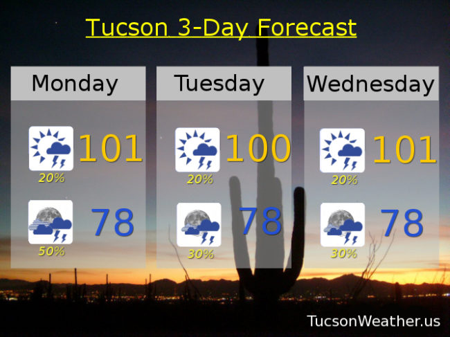
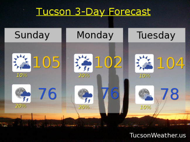
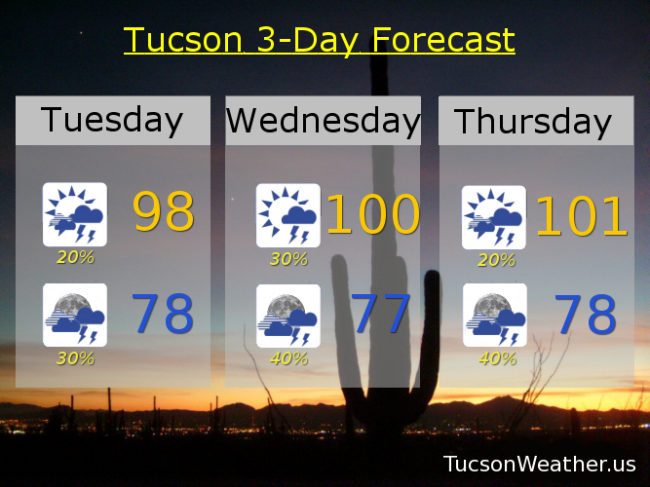
Partly sunny today with a chance for late afternoon storms and a high in the upper 90s.

Mostly cloudy tonight with scattered storms and a low in the upper 70s.

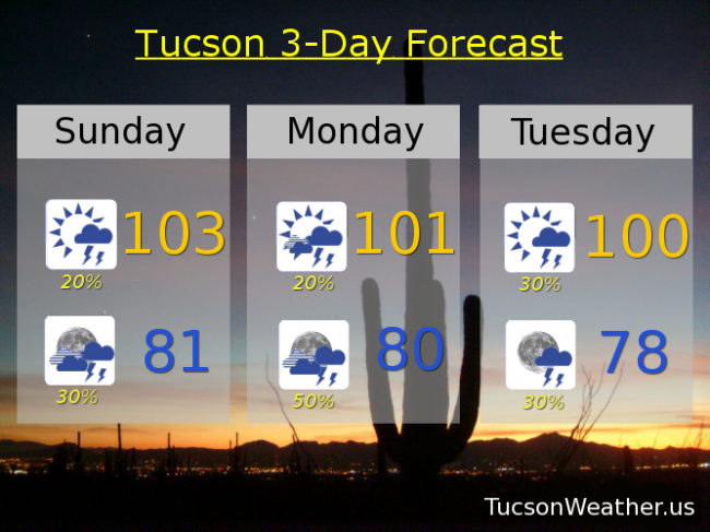
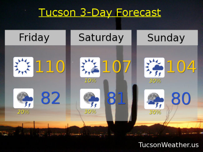
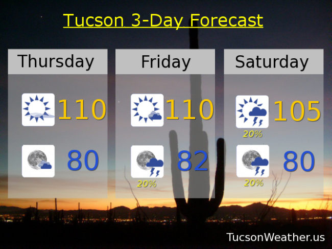
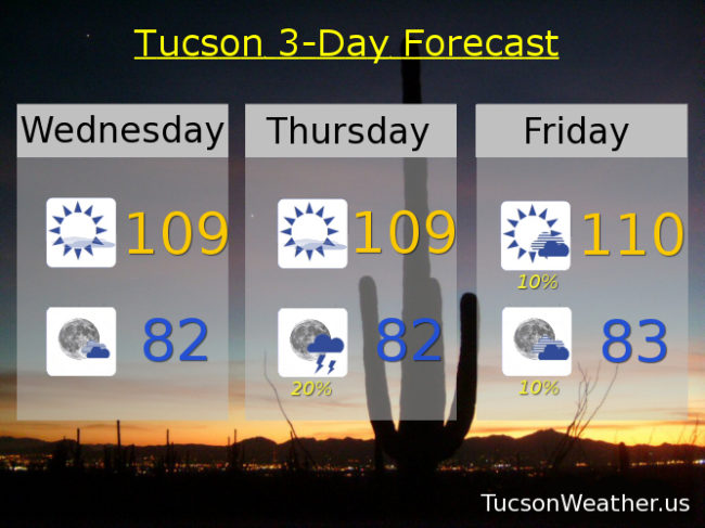
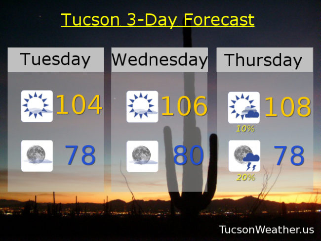
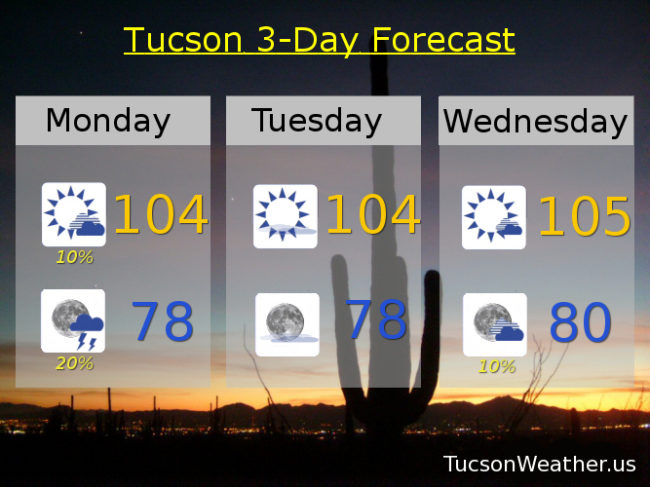
Scattered storms through the weekend with lows in the upper 70s and highs near 100, 101, 102, 102, 100 and 101 respectively.

Forecast for Monday, July 10, 2017

Viva Monsoon 2017!  Someone could see an inch or more of rain tonight!  Hopefully near you.  Scattered storms in the forecast all week and highs where they should be this time of year.  Let the rains begin!

A chance for storms this afternoon with a high near 101.

A good chance for storms before midnight tonight with a low in the upper 70s.

Scattered storms Tuesday, Wednesday, Thursday, Friday, Saturday and Sunday with highs near 100, 101, 103, 102, 102 and 101 respectively.

Forecast for Saturday, July 8, 2017

Monsoon 2017 ramping up.  The heat is on the wane with increasing chances for storms bringing rain!  Eugene may even get in on the action.  High pressure to our north will give us an easterly flow that will bring in more moisture from which storms will feed.  Tropical storm Eugene spinning off the Baja coast may send a little extra tropical moisture our way too to enhance or storm chances.  Sure, today will still be 107, but 100 to 103 the next few days is closer to our season norm of 101.  Viva Monsoon 2017!

Mostly sunny today with a slight chance of an afternoon storm and a high near 107.

Partly cloudy tonight with a chance of an evening storm and a low near 80.

Mostly sunny tomorrow with scattered afternoon and evening storms and a high near 103.  Scattered storms possible Monday through Friday with highs near 102, 100, 101, 102 and 103 respectively.

Forecast for Friday, July 7, 2017

The Monsoon is coming!  The Monsoon is coming!  Increasing moisture will lead to scattered storms across the area starting this weekend and continuing into next week.  We are so ready!  High pressure still large and in charge today with an EXCESSIVE HEAT WARNING in effect until 7:00 p.m. so be warned, the heat will be excessive.  Did I mention scattered storms in the forecast starting this weekend?!

Sunny and hot today with a high near the record of 110.

A storm or two possible this evening, hopefully near you, and a low in the low 80s.

Partly cloudy tomorrow with a slight chance of a storm and a high near 107.  Scattered storms possible tomorrow evening into next week.  104ish Sunday.  Near 102 Monday, Tuesday, Wednesday and Thursday.

Forecast for Thursday, July 6, 2017

An EXCESSIVE HEAT WARNING is in effect from Noon today until 7:00 tomorrow night.  Be warned, the heat will be excessive.  Today’s record high is 109 and tomorrow’s is 110 so we’ll be in the ball park.  Thankfully we should see more moisture and a “cooling” trend starting this weekend.  Outflow from storms in Sonora, Mexico will give us that aforementioned more moisture to work with and maybe an actual start to Monsoon 2017!  Stay tuned.

Mostly sunny and hot today with a high near 110.

Partly cloudy tonight with a low near 80.

Near 110 tomorrow with a chance for evening storms.  Chance for storms Saturday through Wednesday with highs near 105, 103, 104, 104 and 102 respectively.

Forecast for Wednesday, July 5, 2017

Ugh!  So tedious.  The EXCESSIVE HEAT WARNING is baaaack.  In effect starting tomorrow at Noon until 7:00 p.m. Friday.  Be warned, the heat will be excessive.  Make sure you stay hydrated lest you burst into flames.  Today will be hot too with a high of 109 expected.  We get to start some new streaks.  Today will be our second day in a row over 105.  This morning’s low made it the second in a row with a low over 80.  Highs over 105 expected until Saturday.  Lows over 80 expected through Tuesday and possibly beyond.  The good news is even though the high pressure is expanding and flexing its muscles, it’s also moving toward the Four Corners which will give us an influx of moisture and at least a shot at some isolated to scattered storms.  Monsoon 2017, Monsoon 2017, wherefore art thou?!

Mostly sunny today with a high near 109.

Partly cloudy tonight with a low in the low 80s.

Mostly sunny tomorrow with a high near 109 and a chance for isolated showers in the evening with a low in the low 80s.

Isolated storms maybe Friday, 110ish.  20% chance of storms Saturday through Tuesday with highs near 105, 103, 103, 103 respectively.

Forecast for Tuesday, July 4, 2017

Happy Independence Day!  Yesterday was our 20th straight day over 100 degrees and that streak has no end in sight.  It’s gonna be hot and dry for Tucson’s 4th with the best chance for storms to our south and east.  High pressure expanding and moving north toward the Four Corners will give us even hotter weather the next few days with Friday approaching 110 (not again!).  No worries.  Better chances for storms and highs near average (102ish) for this time of year by Sunday into next week.  Still waiting for Monsoon 2017 in Tucson.  Stay tuned!

Mostly sunny today with a high near 104.

Mostly clear tonight with a low in the upper 70s.

Sunny tomorrow near 106.  Slight chance for storms Thursday and Friday, 108 and 109.  A slightly better chance for storms Saturday through Monday with highs 105, 103 and 103 respectively.

Forecast for Monday, July 3, 2017

So you’re saying there’s a chance!  Dewpoints our in the mid 50s this morning which is good and maybe they’ll stick around for a slight chance of a storm or two this afternoon and evening, although the better chance will be south and east of Tucson.  I’ve got good news and I’ve got bad news.  High pressure to our south will be heading north towards the Four Corners over the next couple of days.  Better storms chances as a result Thursday through the weekend, but it will also mean higher highs.  Stay hydrated and stay tuned!

Mostly sunny today with a slight chance for an afternoon storm and a high near 104.

Partly cloudy tonight with a slightly better chance for a storm or two, hopefully near you, before midnight and a low in the upper 70s.

Sunny for the 4th with a high near 104.  105 Wednesday.  About a 20% chance for storms Thursday through Sunday with highs near 107, 107, 105 and 104 respectively.

Forecast for Sunday, July 2, 2017

Monsoon 2017 finally showing some signs of life!  Moisture on the increase this afternoon will give us a slight chance for storms with a better chance tomorrow.  A bit of a break for the 4th and 5th with best storm chances in the mountains but perhaps one or two will come down and visit.  Hopefully near you!  Moisture and storm chances remain in the forecast the rest of the week.  Let’s get this party started!

Mostly sunny today with a slight chance of an isolated storm or two.  Gusty winds this afternoon from any storms that form in the area and from storms to our SE.  High near 105.

Breezy and partly cloudy this evening with a chance for a few storms before midnight.  Becoming clear and calm with a low in the mid 70s.

Chance for storms tomorrow afternoon and evening and a high near 102.  Slight chance for storms for the 4th, 104ish.  Sunny Wednesday 105.  Chance for storms Thursday, Friday and Saturday, 106, 107, 105 respectively.