Category Archives: Daily Forecast

Forecast for Saturday, July 1, 2017

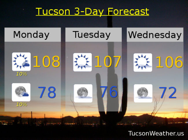
July!  July like a rug.  (I mean you probably don’t, it’s just fun to say)  Very dry again this morning allowing our temperatures to drop into the low 70s.  Very nice!  That same dry air will allow our high to get pretty high with the 17th day in a row of 105 or hotter expected.  Moisture increasing by tomorrow night with a slight chance of a storm, hopefully near you, in the metro.  Scattered storms along the international border to our south and southeast through next week.  Cooling off a bit Monday before we start a new streak of 105+ by Wednesday along with a slight chance of storms.  Monsoon 2017 is trying, but we aren’t quite there yet.  Maybe if we all wash our cars this weekend!

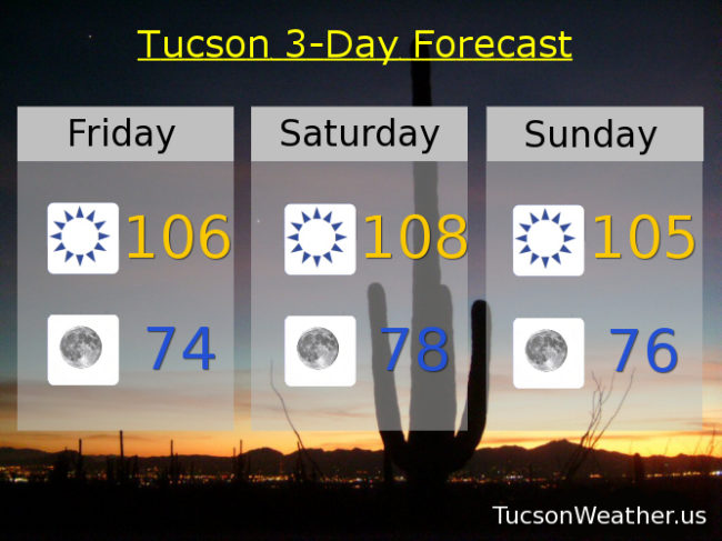
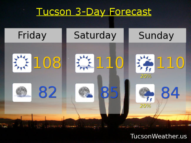
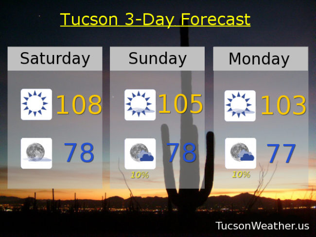
Sunny and hot today with a high near 108.

Mostly clear tonight with a low in the upper 70s.

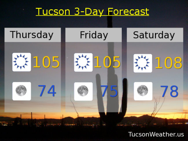
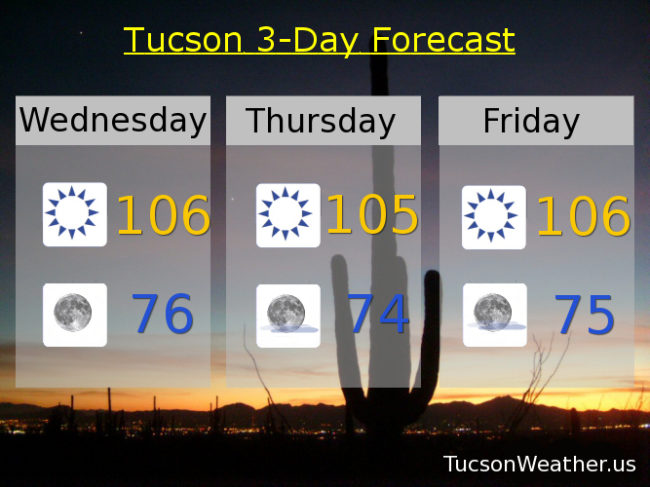
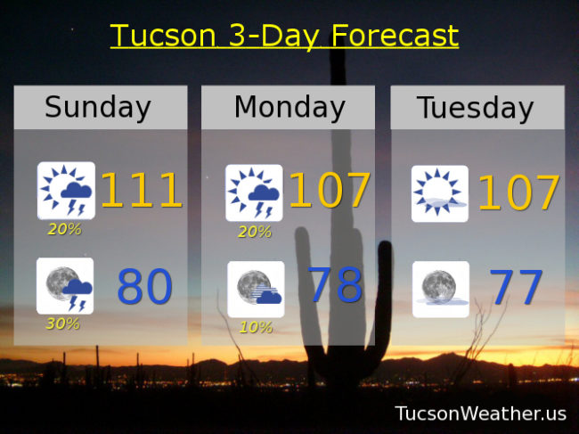
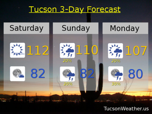
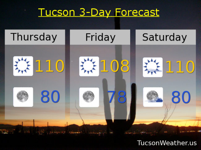
Mostly sunny tomorrow with a slight chance of a storm in the evening and a high near 105.  Ditto for Monday with a high near 103.  Sunny for the 4th 104ish.  105 Wednesday.  Slight chance for storms Thursday and Friday with highs near 107.

Forecast for Friday, June 30, 2017

Refreshingly cool this morning!  Dewpoint is in the teens and that has allowed us to cool off considerably.  Low 70s right now at the airport with 66 on my deck thermometer!  Dry air also warms quickly so it looks like our streak of days over 105 will continue today and keep going through Sunday.  Moisture increasing for slight thunderstorm chances for the 4th and into next week.  Stay tuned!

Sunny today with a high near 106.

Clear tonight with a low in the mid 70s.

Sunny tomorrow near 108ish.  105 Sunday.  103 Monday.  Slight chance for storms Tuesday through Thursday with highs near 104, 105 and 107 respectively.

Forecast for Thursday, June 29, 2017

At least we broke the streak of record days in a row of lows at or above 80 degrees.  79 this morning is refreshingly “cool”!  Hot and dry through the weekend.  I found out yesterday that we are like number 5 all time for consecutive days over 105!  That streak will continue for another 4 days if the forecast comes exactly true.  I’ll hunt down the specifics, but all this record heat is making me feel good about my urban survival skillz!  Moisture on the increase next week for a chance of storms especially south and east of Tucson.

Sunny today with a high near 105.

Clear tonight with a low in the mid 70s.

Sunny tomorrow 105ish.  108 Saturday.  105 Sunday.  104 Monday and for the 4th.  Slight chance for storms Wednesday 104.

Forecast for Wednesday, June 28, 2017

I feel like after last week’s heatwave 105-108 isn’t that bad.  I’m still not hiking in the afternoon.  Dry westerly flow for the next few days and then a moisture return possible starting early next week.  Perhaps a few storms starting then.  Stay tuned!

Sunny today with a high near 106.

Clear tonight with a low in the mid 70s.

Sunny tomorrow near 105ish.  106 Friday.  108 Saturday.  105 Sunday.  Slight chance of storms Monday 104.  Mostly sunny 4th of July 105.

Forecast for Tuesday, June 27, 2017

Yesterday morning we started the morning with a new record high minimum temperature for the date with a not so low low of 83.  We followed that up with a high of 107.  Somewhat similar temperatures today with a degree or three cooler to start the day and perhaps a degree warmer this afternoon.  Drier air is moving in and high pressure moving south for slightly cooler weather this week, but it’s still hot.  Moisture to start to increase from the south by the end of the weekend.  Will it make it far enough north for storm chances in Tucson by the 4th?  Maybe.  We’ll all have to stay tuned!

Sunny today with a high near 108.

Mostly clear skies tonight with a low in the upper 70s.

106 tomorrow.  105 Thursday and Friday.  107 Saturday.  105 Sunday.  Slight chance for a storm or two Monday 103.

Forecast for Monday, June 26, 2017

Lingering moisture today for a few afternoon/evening storms possible.  Hopefully near you!, but they will be few and far between.  High pressure weakening and moving south opening the door for a drying and cooling trend this week.  It’ll still be hot!  Just not over 110 hot.  Looks like a moisture surge will start Sunday/Monday just in time for the 4th of July.  Viva Monsoon 2017!

Mostly sunny today with a slight chance of a storm and a high near 108.

Mostly clear tonight with a slight chance of a storm before midnight and a low near 78.

Sunny Tuesday 107ish.  106 Wednesday.  104 Thursday.  105 Friday.  106 Saturday.  Isolated storms Sunday 105.

Forecast for Sunday, June 25, 2017

Outflow winds from storms to our east have brought us clouds and moisture to start the day.  As a result we are off to a warmer than the last few days start to the day.  Thanx to the moisture increase we are looking at isolated to scattered storms this afternoon and evening!  Expect gusty winds near storms but a few folks will also get a nice shower, hopefully near you.  Today is also our last day of the EXCESSIVE HEAT WARNING that has been in effect all week.  Tedious and buh bye.  Moisture lingers into tomorrow and then our epic high pressure retreats south as a couple of systems move through the Great Basin.  That will put us in a dry westerly flow drying us out some most of this week and also “cooling” us to near normal highs for this time of year.  Tropical Storm Dora will move to near the tip of the Baja Peninsula.  That moisture will move into Mexico priming the pump for the start of Monsoon 2017 for reals!  Stay tuned!

Partly cloudy today with a chance for afternoon storms and a high near 111.

Partly cloudy tonight with scattered storms before midnight and a low near 80.

Mostly sunny tomorrow with isolated afternoon storms and a high near 107.  Sunny near 107 Tuesday.  104 Wednesday.  103 Thursday.  105 Friday.  Chance for storms Saturday 106.

Forecast for Saturday, June 24, 2017

Today’s record is 113 and we’ll be close!  Drier air has moved in with high pressure restrengthening over our heads means another hot day.  EXCESSIVE HEAT WARNING fixin’ to come to and end tomorrow night and good riddance!  Moisture on the increase tomorrow into Monday with a few storms about, hopefully one or two near you.  Then high pressure weakening and moving off giving way to a westerly flow that will dry us out and knock our temperatures closer to average for this time of year (102).  Looks like a surge of moisture after next weekend.  Stay tuned!

Mostly sunny and hot today with a high near 112.

Partly cloudy tonight with a low in the low 80s.

A chance for afternoon and evening storms tomorrow with a high near 110ish anyone?  Chance for storms Monday 107.  Slight chance for storms Tuesday 106.  Slight chance for storms Wednesday 104.  Sunny Thursday 102.  104 Friday.

Forecast for Friday, June 23, 2017

High pressure losing a little more steam today but still rather hot with an EXCESSIVE HEAT WARNING in effect through Sunday.  High pressure restrengthens this weekend for hotter highs back near 110, but moisture on the increase as well.  Monsoon 2017 still warming up so we won’t be in the deep moisture for locally heavy rain or anything like that.  More like a chance for storms with more gusty winds and lightning than rain.  Someone’s is gonna get rained on.  Might as well be you!  Thunderstorm chances continue through Wednesday and we “cool” as we go.  Drier by the end of next week.  Enjoy!

Sunny today with a high near 108.

Mostly clear tonight with a low near 82.

Mostly sunny and hot tomorrow with a high near 110ish anyone?  110ish again Sunday with a few thunderstorms around.  Chance of storms Monday through Wednesday with highs near 108, 106 and 104 respectively.   Sunny Thursday 103.

Forecast for Thursday, June 22, 2017

EXCESSIVE HEAT WARNING continues to continue through Sunday, but the end is neigh!  High pressure moving off opening the door for storm chances starting Sunday into next week!!!  Viva Monsoon 2017!

Sunny today with a high near 110.

Clear tonight with a low near 80.

Sunny tomorrow with a high near 108.  110ish anyone? Saturday.  Chance of storms Sunday 109.  Chance of storms Monday 107.  Mostly sunny Tuesday 105.  Slight chance for storms Wednesday 103.