It’s the calm before the storms. Thanksgiving is looking wet, but not quite cool enough for cold turkey in my estimation. Still. Snow levels dropping by next weekend, but we’ll burn that bridge when we get to it (you know, to stay warm).
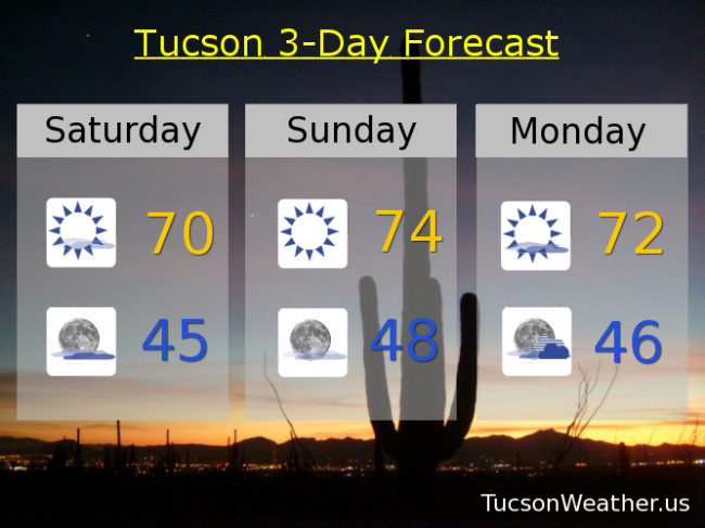
High clouds from time to time today to filter the sunshine and perhaps provide sunrise and sunset enhancement! Very nice this afternoon with a high near 70ish. Also. Tour de Tucson, so you’ll probably be barricaded in your domicile anyway lest you get stuck at a random intersection for 20 minutes. Don’t ask me how I know that 🙂
Considerable high cloudiness tonight with a low in the mid 40s.
Sunshine tomorrow mid 70s! Partly sunny Monday low 70s.
Then it starts to get interesting! Still a lot of details up in the air (see what I did there?), but the gist is this… The low currently to our southwest that is throwing high clouds our way will weaken and move through the area Tuesday night and Wednesday with a 20% to 30% chance for showers respectively. Wednesday’s high in the upper 60s.
Then a stronger and colder system carves a deep trough across the western United States like your Momma carves a turkey. The low will initially drop into southern California before it heads our way spreading rain, mountain snow, and Black Friday deals on umbrellas across the region. Mostly cloudy and breezy on Thanksgiving as a result with a 40% chance for showers and a high in the upper 60s.
A 50% chance for showers and breezy on Friday with a high in the mid 60s. Rain chances and falling snow levels in the offing (what is an offing? asking for a friend) next weekend, but that is beyond the 7 day purview of this forecast, so we’ll all just have to take a wait and see attitude. And of course, Stay Tuned!