It’s the Sunday before Christmas and folks are scrambling like mad. To buy last minute gifts to make people glad. The forecast was warm with a few high clouds. No need for a coat as you fight with the crowds. Here comes Santa Claus! and a storm or two or three. A white Christmas in Summerhaven and rain in the valley. The snow levels drop even lower next weekend. Let the rhyming stop and the forecasting begin!
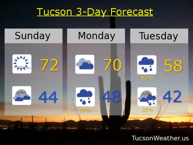
You can always count on “‘Twas The Night Before Christmas” for inspiration for a cheesy morning poem 🙂 One last warm day with a few clouds this evening for possible sunset enhancement. Today’s high quite pleasant around 72.
Mostly cloudy tonight as our first storm approacheth and a low in the mid 40s.
Cloudy tomorrow 70ish. The rain and mountain snow begins Monday night with Tuesday being prime time. Maybe even a thunderstorm Tuesday afternoon to go with our showers. Valley locations expecting a quarter to a half inch of rain from storm numero uno. 4 to 8 inches of snow above 6,000 feet just in time for Christmas as our little poem expressed so cheesily. Tuesday’s high in the upper 50s.
A bit of a break Christmas Day and Boxing Day (Wednesday and Thursday), but still a chance for showers and cool. Highs both days in the upper 50s.
Next storm up on Friday! Partly sunny with showers and a high only in the low 50s. Snow levels down to 4,000 feet Saturday morning? Maybe! Becoming mostly sunny Saturday with a chance for showers and a high in the mid 50s. Early indications are that we will be stuck in this pattern into 2020! Stay tuned.