In case you missed it. I arrived in Lubbock, Texas safely with all of my wordly possessions at about 1:00 a.m. this morning Texas time. I also don’t know if you know I was a morning TV Weatherdude here from 1994 to 2002. So I’m back in Lubbock on Groundhog Day. Irony!
Exciting times ahead in the Tucson Weather Forecast. Winter is returning! (movie announcer voice, “this time it’s personal”) A cold, strong, and quick hitting storm is fixin’ to move through tomorrow into tomorrow night. A chance for rain changing to snow showers tomorrow night with a mix in the transition. It will be COLD! A HARD FREEZE WARNING is in effect tomorrow night/Tuesday Morning and Tuesday Night/Wednesday morning. People, pipes, pets, plants, and other things that start with p that are susceptible to freeze that I can’t think of right now (feel free to add yours in the comments) The quadrillion dollar question. How much snow will we get in town? Unfortunately not a lot. The system won’t have a lot of moisture to work with so little to no accumulations expected, but let’s root for the Chiefs (sorry, I digress) and more than a covering of snow! Let’s outline the (weather) excitement, shall we? Yes let’s!
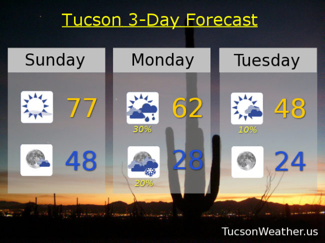
A Super Sunday today with sunshine. A bit breezy with SW winds 5-15 mph and a high in the high 70s! Mostly clear tonight upper 40s.
Partly cloudy and breezy fo sheezy tomorrow (windy?) with south winds 15-25 mph gusting to 35. A chance for showers by afternoon with a high in the low 60s.
A slight chance for rain showers before 10:00 tomorrow night transitioning to a slight chance for snow showers. WNW winds 5-15 mph becoming south. HARD FREEZE WARNING with a low in the upper 20s.
Slight chance for lingering isolated snow showers Tuesday morning otherwise mostly sunny upper 40s. HARD FREEZE WARNING Tuesday night/Wednesday morning mid 20s.
Sunny Wednesday near 50ish. Upper 50s Thursday. Upper 60s Friday. Mid 70s Saturday. Enjoy!