The HARD FREEZE WARNING expires this morning at 8:00, but not before we experience a hard freeze. It’s 31 out there right now (4:37 a.m. what am I doing up since before 4:00 a.m.? great question!) and we will likely fall a few more degrees before the Sun comes up at 7:01. That heavy coat of yours is getting some use this Winter! High temperatures staying well below the average of 69 for this time of year. And…
You might want to sit down for this forecast. A major Winter storm is heading our way. Let’s just go through the snowfall amounts that are in Summerhaven’s official from the National Weather Service forecast. A WINTER STORM WARNING is in effect from 5:00 a.m. tomorrow morning until 5:00 p.m. Friday. Snow, heavy at times, tomorrow with 10-14 inches of snow accumulation possible. Snow, heavy at times, tomorrow night with 14-20 inches of ADDITIONAL snow possible. Snow, heavy at times, Friday with 8 to 12 inches of new snow possible. Add another inch or two perhaps Friday night!!! So. Doing some simple math… that adds up to 33″-48″ (basically three to four feet!) of snow for Summerhaven. WOW! is all I can say. Also. Do you know someone who might let me stay up there in their cabin??? 😃
Meanwhile, back down here at the ranch, we are looking at increasing clouds tonight with a 100% chance for rain tomorrow, tomorrow night and Friday. Rain, heavy at times, with three-quarters of an inch to an inch and a half possible from this storm. Snow levels starting around 5,000 feet tomorrow dropping down to 2,000 – 3,000 feet before the storm is done late Friday night into early Saturday morning. Oracle could see 6″-12″ of snow! Tucson (yes, Tucson) could (maybe!) see a trace to 3 inches of snow! Vail, Corona de Tucson, Catalina, Saddlebrooke will likely have some snowman building snowfall. Tucson maybe! Still a couple dayz out. Stay tuned!!!
The Sun returns by the weekend and we start to warm up some. Still a few degrees below average by Tuesday.
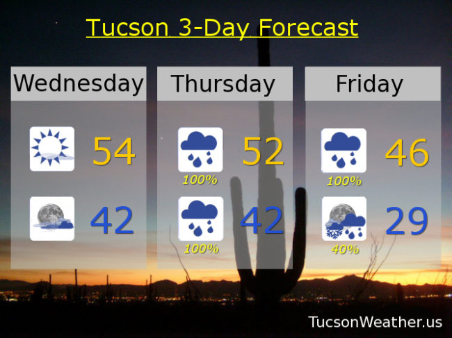
Sunny today with a high in the mid 50s. Increasing clouds tonight low 40s. Showers likely tomorrow morning with rain in the afternoon and breezy with a high in the low 50s. Rain, heavy at times, tomorrow night low 40s. Rain, heavy at times, Friday mid 40s. A chance for rain showers Friday night before midnight then a slight chance for rain and snow showers becoming partly cloudy upper 20s. Sunny Saturday low 50s. Near 60ish Sunday. Low 60s Monday. Mid 60s Tuesday. Enjoy!