It’s snowing! Again. Not everywhere. For example, the radar shows light snow where I live in southern OV, but I’m not seeing any out the window just yet. I am hearing reports of sticking snow in parts of midtown, and the Foothills. Sahuarita, Corona de Tucson, and Vail all getting light snow (half the calories of our regular snow). Light snow also falling at the airport which makes it official! If you are getting snow this morning please let us know. Snow showers in the forecast through the morning hours and our WINTER WEATHER ADVISORY remains in effect until 9:00 this morning with mainly light accumulations in the Metro. Perhaps up to an inch or two in Vail, Corona de Tucson, and Sahuarita/Green Valley.
Skies start to clear this afternoon/evening with temperatures cratering tonight. HARD FREEZE WARNING from 10:00 p.m. until 9:00 tomorrow morning. 24 for a low. Yeah. COLD.
Then we start a bit of a warming trend before our next storm approacheth. Highs actually close to average for this time of year Friday and Saturday. A good chance for rain and mountain snow Saturday night into Monday. Stay tuned!
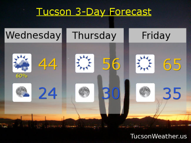
Snow showers likely this morning with clearing skies later this afternoon and a high in the mid 40s. Mostly clear tonight with a low in the mid 20s. Sunny mid 50s tomorrow. Mid 60s Friday. Partly sunny mid 60s Saturday. 40% chance for showers Saturday night and a 50% chance Sunday upper 50s. 10% Monday low 60s. Sunny upper 60s Tuesday. Enjoy!