Forecast for Thursday, May 3, 2018

A Warming Trend Proclamation:

Whereas: The exiting system that brought us a bit of rain and mountain snow is exiting to the east.

and Whereas: High pressure will be building into southern Arizona.

and Whereas: High pressure will bring drier, sinking air that will warm us up quickly.

Therefore: Let it be known across the land that a warming trend is about to begin!

Signed this 3rd day of May in the year of our Lord 2018. – The excelling for excellencies at Tucson Weather.

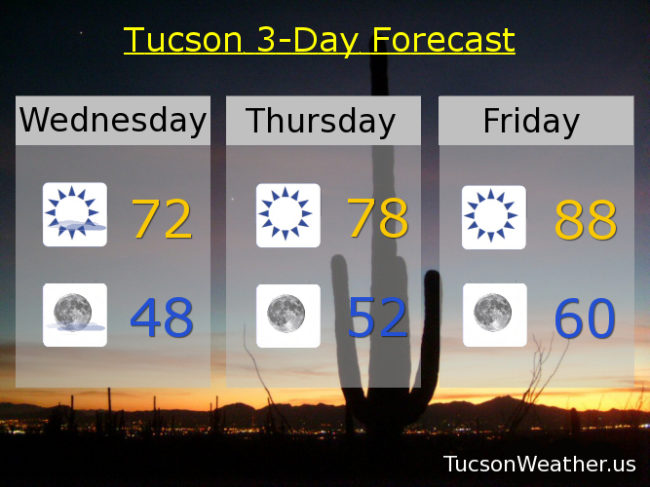
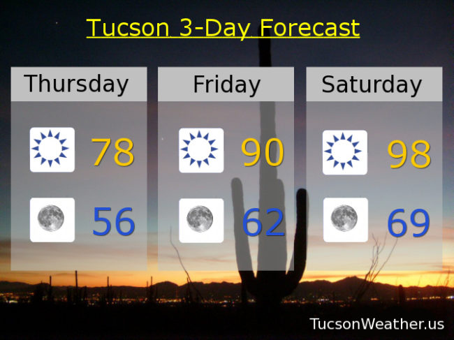
Sunny and super nice today. Chamber of Commerce weather with sunshine and a high in the upper 70s.

Clear skies tonight with a low in the mid 50s.

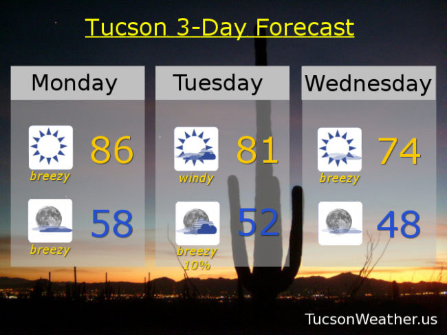
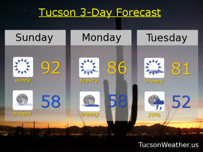
Sunny near 90 tomorrow. Upper 90s Saturday. Near 102 Sunday. 101ish Monday. Near 100 Tuesday. Upper 90s Wednesday. Enjoy!

Forecast for Wednesday, May 2, 2018

One day into May and we are on the board with rainfall! Just a trace at the airport, so it barely counts. It was encouraging to see rain last night. Hopefully there was more than a trace near you. The next big thing will be our first 100 degree day on Sunday. Summer’s coming! Best enjoy the last of the 70s today and tomorrow.

Mostly sunny today with a lingering breeze out of the SSE 5-15 mph and gusty with a high in the low 70s.

Mostly clear tonight with a low in the upper 40s.

Sunny upper 70s tomorrow. Upper 80s Friday. Upper 90s Saturday. 101ish Sunday. Upper 90s Monday and Tuesday. Be cool!

Forecast for Tuesday, May 1, 2018

May Day, May Day. This is southern Arizona. Do you copy? I repeat, do. you. copy? We have an approaching storm from California kicking up our winds. A RED FLAG WARNING is in effect from 11:00 this morning until 6:00 tonight. Please send extra resources to make sure that people who smoke keep their butts in their car. Over. Oh, cooler today too with a high near 81ish. SW winds 15-25 mph gusting to near 35.

Our system moves through tonight and we’ll keep it breezy until midnight. The best news is the 20% chance for showers and/or a thunderstorm, hopefully near you! Snow levels as low as just below 7,000, so there’s that. Low in Tucson in the low 50s.

Sunny with lingering breezes tomorrow behind the exiting low. SSW winds 5-15 mph and gusty with a high in the mid 70s. Nice!

Warming up quickly through the weekend. Upper 70s Thursday. Upper 80s Friday. Mid 90s Saturday. Near 100 Sunday! Upper 90s Monday. Welcome to May.

Forecast for Monday, April 30, 2018

Another day. Another RED FLAG WARNING. Yesterday’s peak wind gust at the airport was 36 mph out of the west. We should experience similar conditions today albeit a little cooler and not quite as windy. Winds becoming WSWesterly 15-20 mph gusting to around 30 with a high in the mid 80s.

Our storm approacheth even closer tomorrow for a windier day with more clouds and cooler too. A FIRE WEATHER WATCH for tomorrow for SW winds 20-25 mph gusting to near 40 and a high in the low 80s.

A slight chance for showers or a thunderstorm Tuesday night! Snow levels may even drop below 7,000 feet. Breezy too with SW winds gusting to near 30 and relaxing after midnight and a low in the low 50s.

The storm clears out exit stage east Wednesday with some lingering breezes gusting to around 25 and a high in the mid 70s.

Fast warm up through the weekend. Sunny upper 70s Thursday. Upper 80s Friday. Mid 90s Saturday. Upper 90s Sunday. Enjoy and Good Luck!

Forecast for Sunday, April 29, 2018

There’s a lot of wind in this forecast as a strong system to our north approacheth from the Pacific Northwest. So much so that the National Weather Service has issued a RED FLAG WARNING starting at Noon today until 7:00 tonight. Not quite as windy tomorrow but a FIRE WEATHER WATCH has been issued from Noon tomorrow until 7:00 p.m. Please be careful setting stuff on fire lest you burn it all down! By Tuesday a secondary low travels further south around the backside of the first low. Looks like we might get into a chance for thunderstorms and/or showers Tuesday night situation! Maybe even a little snow above 6,500 feet!!! Turning much cooler with highs Wednesday and Thursday in the 70s. Looks like April will end with no rain for the month. Zero. Zip. Nada. May may be a different story!

Sunny and windy today with areas of blowing dust and human misery. Winds becoming SW this afternoon 15-25 mph gusting to near 40 and a high in the low 90s.

Breezy tonight with SW winds 10-20 mph gusting to near 30 relaxing after midnight and a low in the upper 50s.

Sunny and breezy tomorrow with WSW winds 10-20 mph gusting to near 30 and a high in the mid 80s.

Partly sunny and breezy Tuesday with SW winds 15-25 mph gusting to near 35 and a high in the low 80s.

Chance for thunderstorms Tuesday evening and a chance for showers overnight with a low in the low 50s.

Mostly sunny Wednesday 75ish. Upper 70s Thursday. Upper 80s Friday. Mid 90s Saturday.