Forecast for Sunday, March 18, 2018

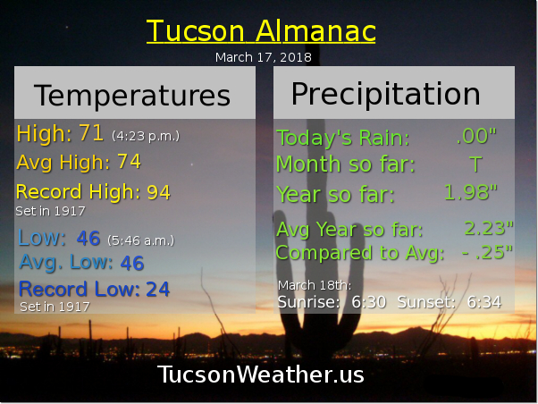
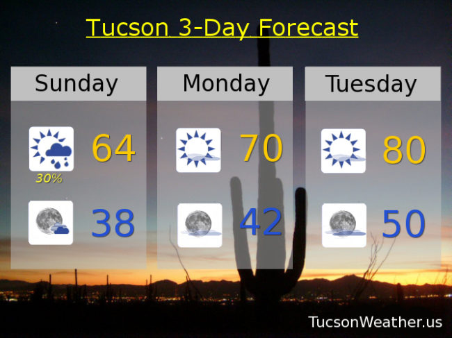
Still a chance for showers this morning, but as I write this at 6:45ish in the morning, still nothing. Most of the computer models are still showing some light rain across the area, but a couple models say we will stay dry, so it’s possible we might get skunked. Still a chance for an inch or two of snow in the mountains. Winds becoming WNWesterly 5-15 mph and gusty once the front moves through. Clearing skies this afternoon with a high only 64ish.

Partly cloudy tonight with a low in the upper 30s!

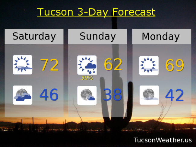
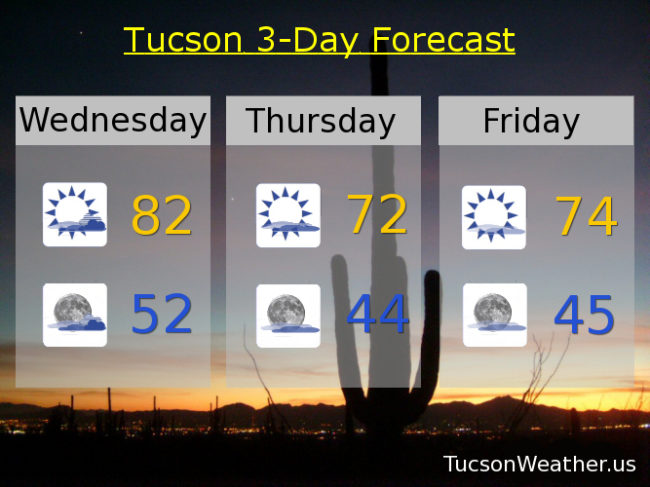
Mostly sunny tomorrow near 70. Near 80 Tuesday. Mid 80s Wednesday!

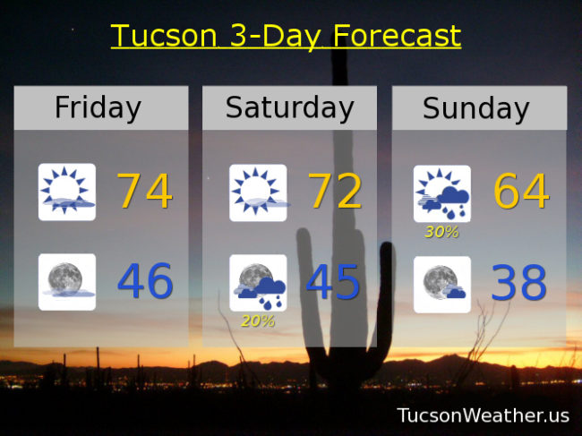
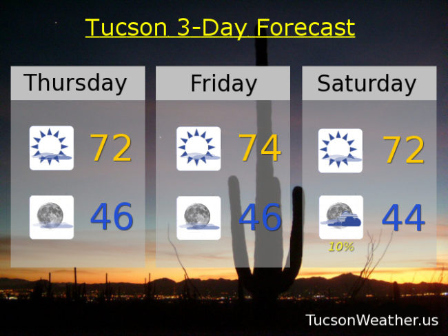
Another storm approacheth Thursday with mostly cloudy skies low 80s. Slight chance for light rain Thursday night and Friday. Friday upper 70s. Sunny upper 70s Saturday. Enjoy!

Forecast for Saturday, March 17, 2018

Top o’ the afternoon to ya! Sorry for the late update, but I wanted to make sure I didn’t skip today because we have a bit o’ excitement headed our way tonight/tomorrow. A storm approacheth and the wind has been picking up a bit this afternoon. Clouds will be on the increase tonight with a cold front blowing through sometime around 3am – 5am. Most of our expected rainfall should occur ahead of and near the front. Not a lot of moisture to work with and the main system will be to our north, so likely less than a tenth of an inch for most valley locations. An inch or three of snow possible above 5,500 – 6.000 feet, so a little bit. Rain ends tomorrow morning with clearing skies by afternoon and much cooler with a high only near 62. Gusty SSW winds overnight relaxing some during the day tomorrow.

Mostly sunny Monday with a high near 69. Upper 70s Tuesday.

Another storm missing us to the north will give us more clouds Wednesday and a slight chance of rain Thursday. Low 80s both days. Slight chance for a lingering shower Friday mid 70s. Sunny Saturday mid 70s. Enjoy!

Forecast for Friday, March 16, 2018

It’s Friiidaaay!!!

Our next storm approacheth. Our exiting system that brought snow to northern Arizona cooled us off quite a bit yesterday with a high of 70. A little warmer today as slight ridging occurs ahead of our next storm currently off the northern California coast.

High clouds, thick at times, today with a high in the mid 70s.

Partly cloudy tonight with a low in the mid 40s.

Mostly sunny tomorrow with a high in the low 70s.

Then our system moves into Arizona Saturday and moves through Sunday. Pretty good chance for showers but they should be on the light side Saturday night and Sunday morning. Only expecting a tenth of an inch or less in valley locations. A little bit of snow above 6,000 feet in our local mountains. Showers likely ending by Noon Sunday with a high only in the mid 60s.

Mostly sunny Monday after a chilly start (mmm chili) with a high in the upper 60s to near 70. Upper 70s Tuesday. Mid 80s (or warmer) Wednesday. Low 80s Thursday. Enjoy!

Forecast for Thursday, March 15, 2018

A couple of storms missing us to the north will kick up our breezes a bit and knock our temperatures back below average through the weekend. A slight chance for a few showers Saturday night otherwise high and dry. Warming up quickly next week as high pressure builds back in. Spring has sprung!

A mix of clouds and sunshine today and a bit breezy. West winds 5-15 mph and gusty with a high in the low 70s.

Mostly clear tonight with a low in the mid 40s.

Mostly sunny tomorrow with a high in the low to mid 70s. Low 70s Saturday. Slight chance for rain Saturday night near 40. Mostly sunny Sunday upper 60s. Low 70s Monday. Upper 70s Tuesday. Low 80s Wednesday.

Forecast for Wednesday, March 14, 2018

Depends on who you are I guess, but I think I have a bit of bad news. Our decent shot of rain this weekend has pretty much evaporated as it looks like the storm track will stay too far north. We will get to enjoy some breeziness and cooler temperatures as a series of storms miss us to the north, so there’s that.

Partly sunny today and warm with a WSW breeze 5-15 mph this afternoon. Today’s high in the low 80s.

Mostly cloudy tonight and maybe some sunset enhancement. Maybe. With a low in the low 50s.

Partly cloudy and cooler tomorrow with west winds 5-15 mph and gusty with a high in the low 70s. Mid 70s Friday. Low 70s Saturday. Slight chance for a shower Sunday upper 60s. Mostly sunny low 70s Monday.  Upper 70s Tuesday.