Forecast for Monday, March 12, 2018
Looks like more rain on the way by the end of this week. Maybe even a few sprinkles sooner than that. Maybe. High pressure building in for the next couple of days with highs in the 80s. Then a deepening trough of low pressure off the west coast will start to sling some disturbances in the force our way with the main low moving across southern Arizona this weekend. There are still differences in the computer models on how all of this will go down so stay tuned for details as we get closer. Right now we’ll just broad brush a chance for showers Friday night and Saturday perhaps lingering into Sunday. Stay tuned!
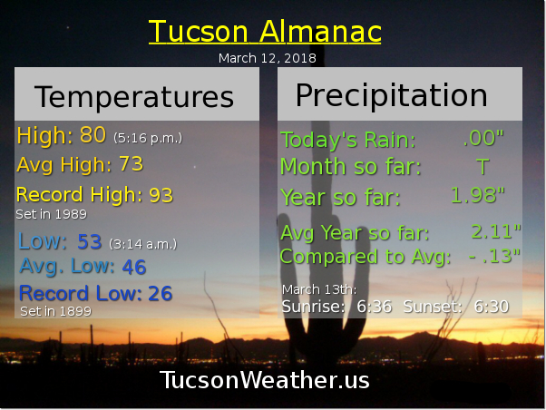
Mostly sunny today and warm with a high near 80.
Mostly clear tonight with a low in the low 50s.
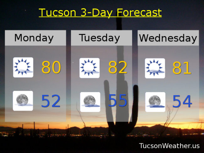
Mostly sunny tomorrow with a high in the low 80s. Low 80s Wednesday. Mid 70s Thursday. Slight chance for showers Friday mid 70s. Better chance for showers Saturday and breezy upper 60s. Slight chance for showers Sunday upper 60s.
Almanac for Sunday, March 11, 2018

Forecast for Sunday, March 11, 2018
Only a trace of rain at the airport yesterday and another trace this morning. I’m sure I got more here in OV, but not a lot more. We’ll take it! Warming back into the 80s this week and then we set our sights on our next storm. A chance of rain starting as early as Thursday night with Friday and Saturday being prime time. More than a trace this time!
Partly sunny today with a high in the low 70s.
Partly cloudy tonight with a low near 50ish.
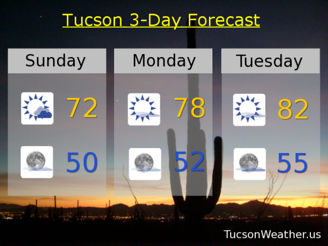
Mostly sunny tomorrow with a high in the upper 70s. Low 80s Tuesday. Mid 80s Wednesday. Upper 70s Thursday. Chance for showers Friday and Saturday with highs in the low 70s and upper 60s respectively. Enjoy!
Almanac for Saturday, March 10, 2018

Forecast for Saturday, March 10, 2018
The good news is the computer models as interpreted by the humans at the National Weather Service are saying that our chance of rain tonight into tomorrow morning has gone up to 30%. The bad news is we are still expecting rainfall amounts to be on the light side. Maybe a tenth or less for valley locations. The good news is it looks like a more significant storm should arrive by Friday into next weekend for a better chance for rain and mountain snow.
Partly sunny today with a warm high near 81ish.
Mostly cloudy tonight with a chance for light rain showers and a low in the mid 50s.
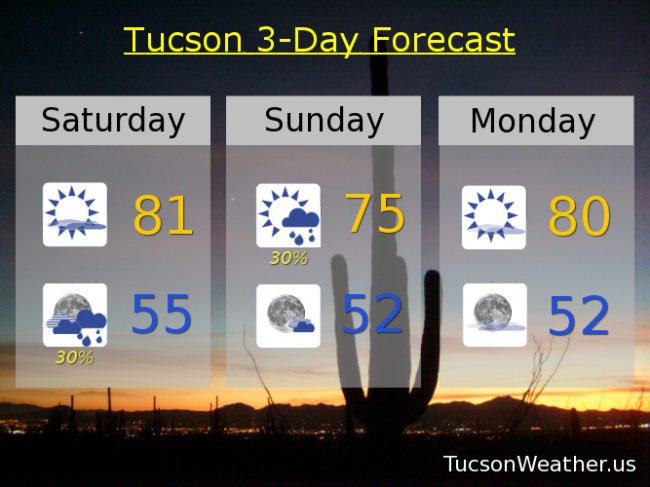
Partly sunny tomorrow with a chance for morning showers and a high in the mid 70s.
Mostly sunny Monday near 80. Low 80s Tuesday. Near 80 Wednesday. Mid 70s Thursday. Scattered showers Friday near 70.
Almanac for Friday, March 9, 2018
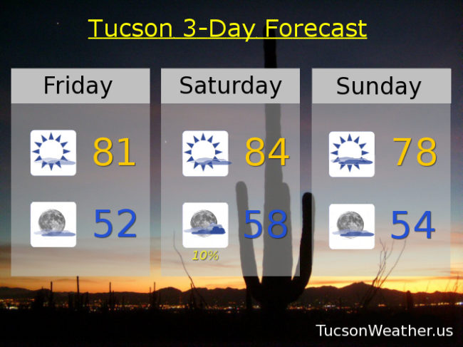
Forecast for Friday, March 9, 2018

The high clouds have passed. For now. Mostly sunny today with still a few high clouds around for possible sunrise and sunset enhancement. Warm with a high near 81ish.
Partly cloudy tonight with a low in the low 50s.
More high clouds in here tomorrow. Call it partly sunny and warm with a high near 84.
Slight chance for light rain tomorrow night, so not expecting much. Low in the upper 50s.
Partly sunny Sunday upper 70s. Mostly sunny Monday near 80. Low 80s Tuesday and Wednesday. Partly sunny Thursday mid 70s. Perhaps a stronger storm in here by next weekend. Perhaps. Stay tuned!
Almanac for Thursday, March 8, 2018

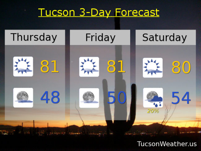
Forecast for Thursday, March 8, 2018
Happy Friday Eve! (makes the weekend seem closer)
High clouds, thick at times, still streaming our way from the south and southeast into the weekend. A disturbance in the force should provide some light showers late in the weekend, but amounts should be minimal. Staying warm as the main storm track stays to the north.
Considerable high cloudiness today but still warm. The clouds may be too extensive for sunrise and sunset enhancement. We’ll see. High in the low 80s.
Mostly cloudy tonight with a low in the upper 40s.
Less high cloudiness tomorrow. Call it mostly sunny with a high in the low 80s. Partly sunny Saturday near 80. Slight chance for light rain Saturday night into Sunday with a high in the mid 70s. Mostly sunny Monday upper 70s. Sunny Tuesday upper 70s. Near 80 Wednesday. Enjoy!