
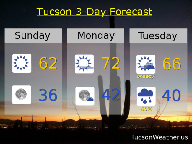
Forecast for Sunday, February 25, 2018
Our Tuesday night/Wednesday storm is coming into focus as we get closer. Looks like a tenth to a quarter inch of rain for valley locations around the metro with two to five inces of snow in the mountains. Snow levels starting out around 6,500 feet crashing to 3,500 feet by Wednesday morning.
Right now we are between systems and that means sunshine and warming temperatures. A few degrees warmer than yesterday today with a high in the low 60s. Low tonight in the mid 30s. A degree or two above average for this time of year tomorrow with a high in the low 70s.
Breezy with increasing clouds Tuesday as the storm approacheth with a high in the mid 60s. Showers likely Tuesday night with a low near 40. Scattered showers mainly in the morning Wednesday with a high in the mid 50s.
Sunny and warming up Thursday with a high in the upper 60s. Low 70s Friday and Saturday. Enjoy!
Almanac for Saturday, February 24, 2018

Forecast for Saturday, February 24, 2018
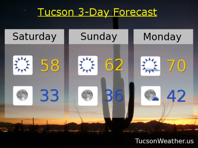
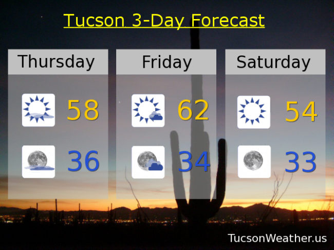
Some frost out there this morning with a low of 35 so far. Yesterday’s high was a good 6 degrees below the average of 70 for this time of year and today will be cooler. It may not feel as cold since the wind will be lighter. In any event, our active weather pattern is remaining rather active with another weak system missing us to the north today. We’ll stay sunny but cool with a high in the upper 50s.
Clear skies tonight with a low near freezing to start your Sunday. Tomorrow’s high recovering to the low 60s.
Sunny Monday near 70!
A storm approacheth Tuesday with a slight chance for showers and breezy with a high in the mid 60s. Best chance for rain and mountain snow will be Tuesday night into Wednesday with a low near 40 and a high in the upper 50s.
Back to sunshine Thursday with a high in the upper 60s. Low 70s Friday.
Almanac for Friday, February 23, 2018

Forecast for Friday, February 23, 2018
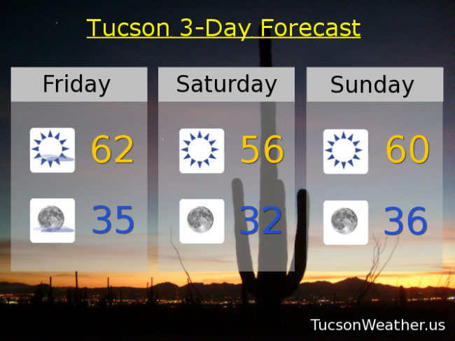
It’s Friiidaaay!
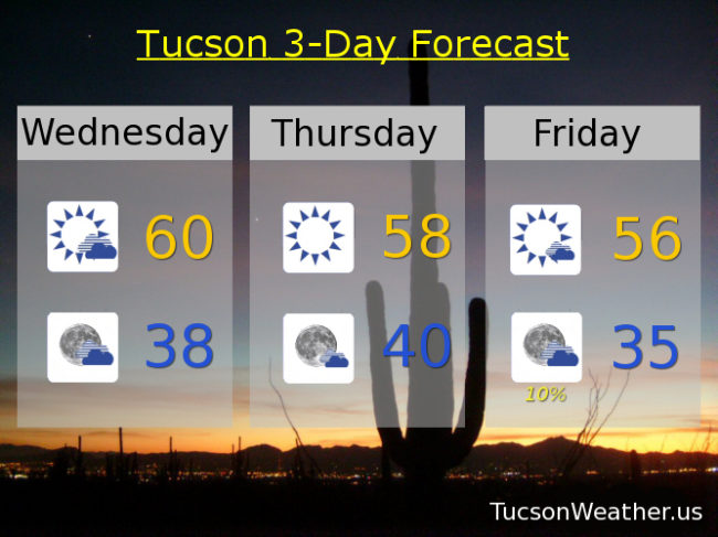
A system missing us to the north will bring us a few clouds and breezes today and keep us 8 or so degrees below average for this time of year. Call it mostly sunny with winds becoming westerly 10-20 mph this afternoon and a high in the low 60s.
Mostly clear skies tonight with a low in the mid 30s.
Cooler tomorrow behind the system with a high in the mid 50s.
Near freezing Sunday morning with sunshine warming to near 60. Upper 60s Monday.
A storm currently raining and snowing on southern Alaska is forecast to drop south and move into southern Arizona Tuesday and Wednesday. Scattered showers and mountain show with a high Tuesday in the mid 60s and mid 50s Wednesday. Sunny Thursday mid 60s.
Almanac for Thursday, February 22, 2018
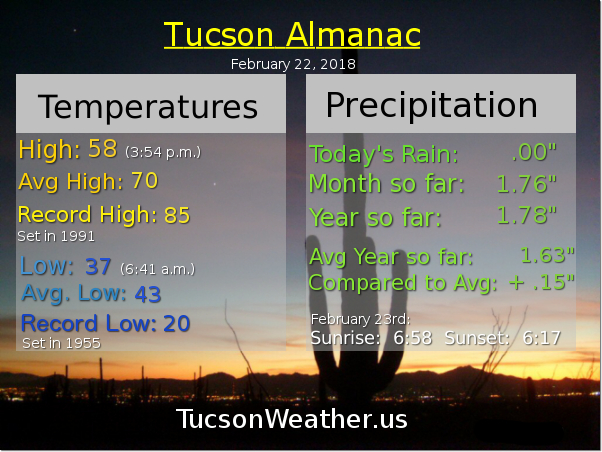
Forecast for Thursday, February 22, 2018
Staying on the cool side as a system that missed us to the north yesterday exits and another system is set to miss us to the north tomorrow tomorrow night. Unfortunately staying dry this far south but a few clouds this evening and tomorrow for possible sunset and sunrise enhancement. Looking really interesting around the middle of next week as a cold storm currently in the Bering Sea chugs our way for a better chance for rain and mountain snow. How low will the snow level go? We’ll keep a close eye on it and let you know as it gets closer. Stay tuned!
Mostly sunny today with a high in the upper 50s.
Mostly clear skies tonight with a low in the mid 30s.
Mostly sunny to partly cloudy tomorrow and breezy with west winds 10-20 mph by afternoon and a high in the low 60s. Sunny and cool Saturday mid 50s. Near freezing Sunday morning with high near 60. Upper 60s Monday and Tuesday. Chance for showers Wednesday low 60s.
Almanac for Wednesday, February 21, 2018

Forecast for Wednesday, February 21, 2018
A series of storms missing us to the north will keep us on the cool side through the weekend. Not much in the way of rain from these fast moving systems, but we will see some cloudiness from time to time and a few breezes.
Increasing clouds today and cool with a high near 60.
Partly cloudy tonight with a low in the upper 30s.
Sunny tomorrow with a high in the upper 50s.
Mostly sunny and breezy Friday with a slight chance for showers Friday night. High in the mid to upper 50s. Low in the mid 30s.
Sunny Saturday mid 50s. Low 60s Sunday. Upper 60s Monday and Tuesday.