
Forecast for Saturday, February 10, 2018
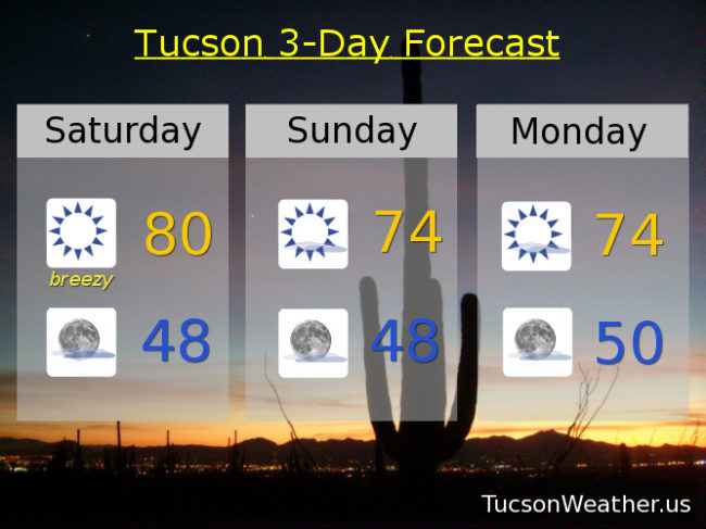
Breezy today as a system moves across the Four Corners. Since it has been so dry for so long plus low humidity today plus gusty winds equals the National Weather Service issuing a RED FLAG WARNING from 1:00 this afternoon until 6:00 this evening. I’m still not sure if they fly a red flag outside the weather service office, but I do know that if you smoke you should probably make sure you keep your butts in the car! Today’s high near 80 which is the warmth we’ve grown accustomed to this February.
But wait! Cooler air behind the system will knock us down into the mid 70s tomorrow, Monday and Tuesday.
Then. An upper low will sink southward and park off the southern California coast. As it sits and spins it will pull moisture northward into southern Arizona. Confidence is growing that we will see rain mid to late next week! How much? The computer models don’t agree on that yet. Maybe .20″ on the low side and close to an inch on the high side.
So. Slight chance for showers by Wednesday afternoon and a high in the low 70s. A decent chance for showers Thursday with a high in the upper 60s. Chance for showers Friday near 70. Stay tuned!
Almanac for Friday, February 9, 2018

Forecast for Friday, February 9, 2018
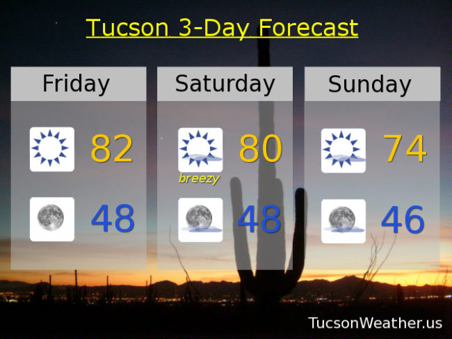
Interesting times we live in and interesting weather to talk (type-o) about! Yesterday’s high of 84 shattered the old record of 81 set in 2000 & hit again in 2006 & 2016. 81 WAS the lowest record high of the month. Congratulations 2018. I knew you could clear this up for us.
Now. Let’s try to predict the future (with considerable help from the National Weather Service, of course). First of all, it’s FRIIIDAAAY!!! Today looks very nice. Nuthin’ but Sun. Low 80s. The record of 86 set last year should be safe. Clear skies tonight with a low in the upper 40s.
A system misses us to the north tomorrow kicking up some wind as it breezes through the Four Corners. Winds becoming SW in the afternoon gusting to near 30, so a great day to fly a kite maybe. High near 80.
Cooler Sunday behind the system mid 70s. Mid 70s Monday. Low 70s Tuesday as our next storm approacheth.
By Wednesday an upper level low will be moving down the California coast to near L.A. or San Diego before it makes the turn our way. Tropical moisture should get caught up in the southerly flow ahead of the system for a slight chance for rain Wednesday and a high near 70. The storm is scheduled to move through on Thursday with a good chance for showers and a high in the upper 60s. Snow levels remaining quite high with this one. Maybe down to 7,000 feet. It’s still a ways out and forecasts sometimes change. Of course we’ll keep you posted as we go. Stay tuned!
Almanac for Thursday, February 8, 2018

Forecast for Thursday, February 8, 2018
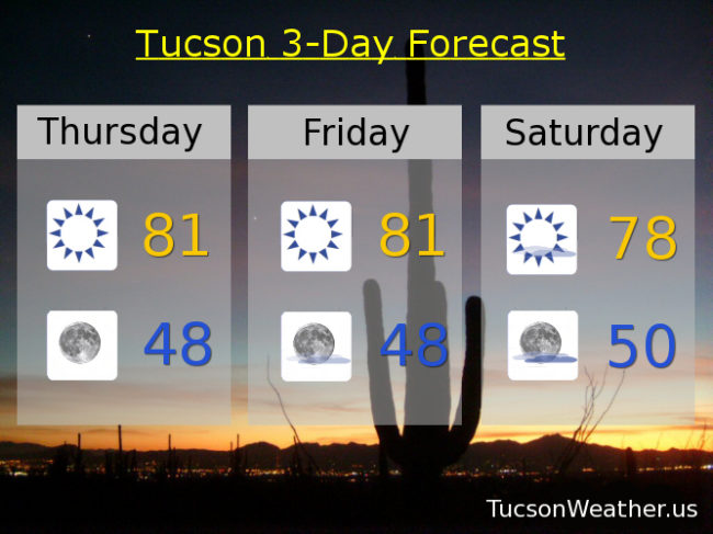
The bar is set rather low today. 81 is our record high set in 2000 & hit again in 2006 & 2016. 81 is the lowest record high for the month of February. If our forecast comes exactly true we will tie it once again! 81ish again tomorrow and upper 70s Saturday as high pressure still exerts its influence on the west coast. All that changes as a couple of systems head our way. The first one Sunday and the second Tuesday into Wednesday. Unfortunately the forecast looks dry albeit cooler. Mostly sunny Sunday mid 70s. Low 70s Monday. Near 70 Tuesday and Wednesday. Enjoy!
Almanac for Wednesday, February 7, 2018
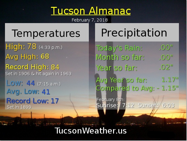
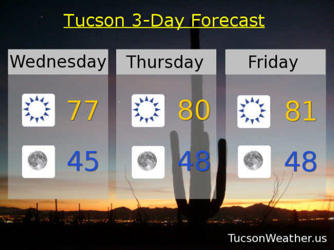
Forecast for Wednesday, February 7, 2018
Nary a cloud in the sky and high temperatures running 9-13 degrees above average for early February. Some relief in sight, but it looks like it will stay dry. A weak system moves through on Sunday for a few degrees of cooling. A stronger storm Tuesday gives us a slight chance for showers and it’ll be cooler, but still a degree or two above average for this time of year. It’s still a ways off so stay tuned!
Sunny today with a high in the upper 70s.
Clear skies tonight with a low in the mid 40s.
Sunny near 80 tomorrow. Low 80s Friday. Upper 70s Saturday. Mid 70s Sunday. Low 70 Monday. Slight chance for showers Tuesday near 70.
Almanac for Tuesday, February 6, 2018

Forecast for Tuesday, February 6, 2018

A change in the weather pattern coming to southern Arizona by late this weekend with a slight chance for rain even! (so you’re saying there’s a chance)
High pressure still over the west coast right now, but a system moving near the Four Corners today will kick up our breezes a bit and cool us off a degree or three. South-southeast breezes 10-15 mph becoming northwest and gusty this afternoon. Still warm with a high in the upper 70s and a few clouds for possible sunrise and sunset enhancement.
Mostly clear skies tonight with a low in the mid 40s.
Sunny tomorrow with an east breeze 5-15 and a high in the upper 70s. An east-southeast breeze 5-15 Thursday low 80s. Sunny low 80s Friday. Upper 70s Saturday. Slight chance for showers Sunday low 70s. Slight chance for showers Monday 70ish.