Tag Archives: Daily Forecast

Forecast for Sunday, January 28, 2018

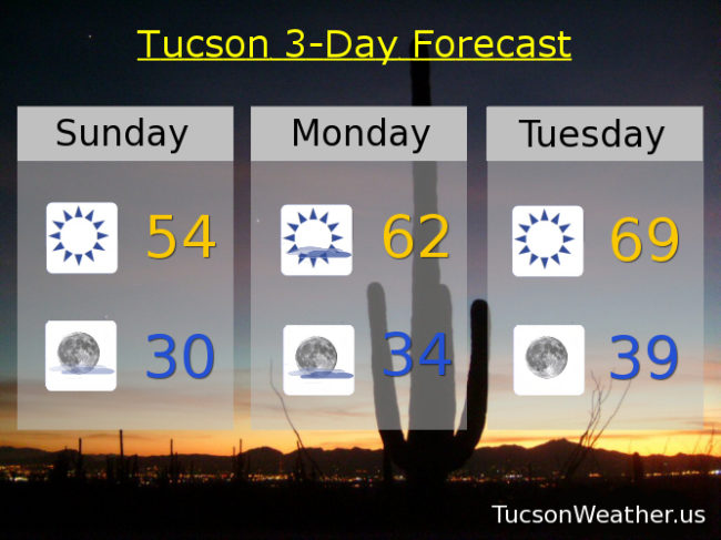
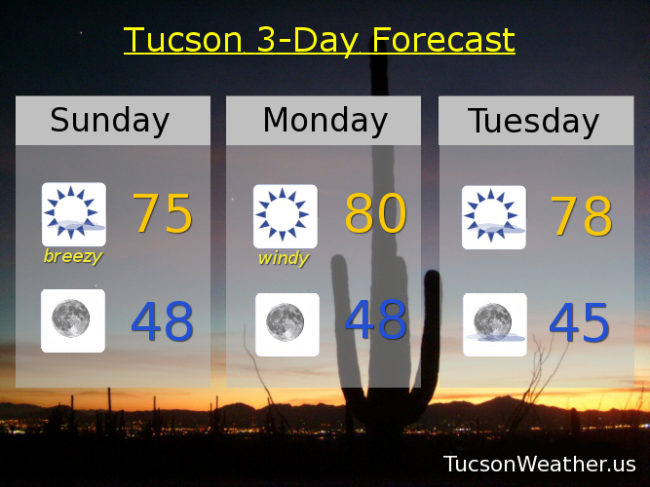
Wind and warmth the weather story for the next couple of days. East breezes already picking up this morning and should be gusting to near 30 mph as we go through the day. A few high clouds too for possible sunrise and sunset enhancement although they will be on the decrease later this afternoon. Today’s high near 75ish. Clear skies tonight with winds relaxing and a low in the upper 40s.

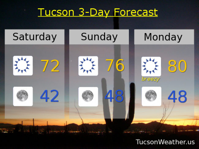
Windy tomorrow with east winds 20-25 mph gusting to near 40! Could see some areas of blowing dust even. Sunshine and warm otherwise. The record high of 82 was set in 1986. We’ll be close with an expected high near 80. Stay tuned!

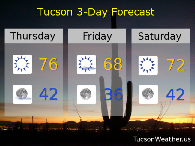
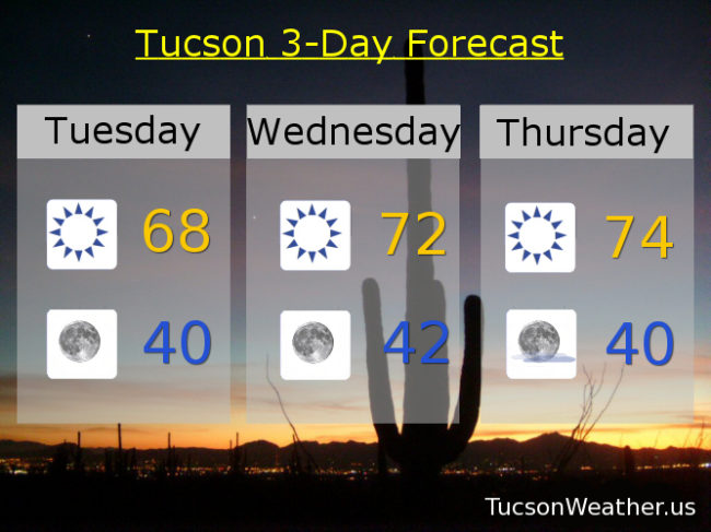
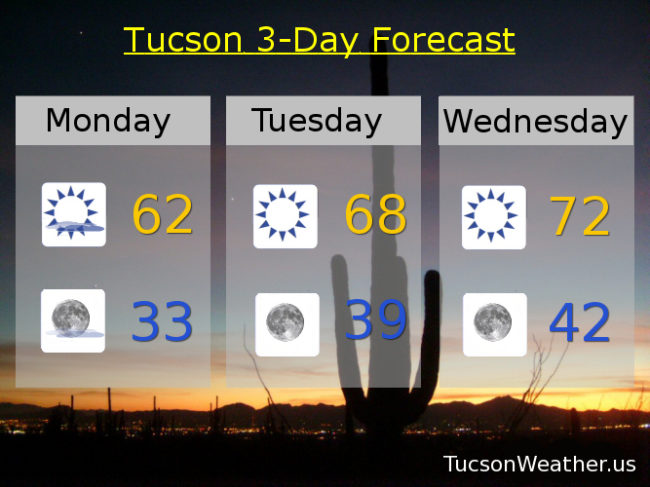
Mostly sunny and nice Tuesday with a high near 78. Sunny 78ish Wednesday. Upper 70s Thursday, Friday and Saturday too. Enjoy!


Forecast for Saturday, January 27, 2018

All quiet on the southwestern front. A pretty average day for this time of year yesterday. The high of 67 was 1 degree above average and the low of 39 was 1 degree below. Average those and you get, well, average. Temperatures pushing higher as high pressure noses back into our business. Low 70s today. Mid 70s tomorrow. Gusty east winds Monday will help push our high to near 80. Winds relax on Tuesday with a high in the upper 70s. Upper 70s Wednesday too. Mid 70s Thursday and upper 70s Friday.

The National Weather Service says we are a lock for the warmest January on record. Our persistent pattern is expected to persist into February. Continued warmth for us while the northern, central, eastern and even southern parts of the nation look forward to another arctic outbreak. Yikes! Enjoy not having to shovel sunshine!

Forecast for Friday, January 26, 2018

It’s Friiidaaay!!!

A cool front blowing through southern Arizona today will, well, cool us off. Upper 60s this afternoon with a few high clouds for possible sunrise and sunset enhancement.

Mostly clear tonight with a low in the upper 30s.

Warming up this weekend with a high Saturday in the low 70s. Easterly breezes Sunday and Monday helping to push our highs even higher with upper 70s Sunday and near 80 Monday. Upper 70s Tuesday and Wednesday. Mid 70s Thursday. Enjoy!

Forecast for Thursday, January 25, 2018

Another sunny warm day in our corner of the state. Some say it’s tedious, some think it’s great! Sunshine and mid 70s as high pressure rules. Those buried under a blizzard drool.

A high cloud or two perhaps overnight. Mostly clear skies with a first quarter Moon shining half bright.

A storm well to our north a cooler tomorrow brings. Upper 60s for a Friday the Monday through Friday worker sings!

A warming trend again as the weekend begins. Low 70s Saturday and upper 70s Sunday outside with friends.

Near record warmth on Monday predicted. Near 80 the high with sunshine unrestricted. Upper 70s on Tuesday the anniversary of my birth. Let them eat cake! and ice cream for whatever that’s worth. A few degrees of cooling mid next week. Mid 70s Wednesday continuing our warm streak. Enjoy!

Forecast for Wednesday, January 24, 2018

The warm up continues. A bit of an easterly breeze today especially for easterly breeze favored areas such as midtown, eastern parts of town and the south side. Oro Valley not so much, but still a little breezy in the OV. Call it 10-20 mph and gusty with a high today in the low to mid 70s.

Clear skies tonight with a low in the low 40s.

A few high clouds tomorrow for possible sunrise and sunset enhancement with a high in the mid 70s.

A storm missing us to the north on Friday will knock our temperatures back a few degrees with a high in the upper 60s. Sunny Saturday low 70s. Upper 70s to near 80 Sunday. Upper 70s Monday. Mid 70s Tuesday. Enjoy!

Forecast for Tuesday, January 23, 2018

Freezing again this morning with a low of 30 so far at the airport. An easterly breeze and nuthin’ but Sun will help our high rebound to the upper 60s this afternoon.

Not as cold tonight with clear skies and a low near 40.

High pressure building back in tomorrow and Thursday with highs in the low to mid 70s respectively.

A storm misses us to the north on Friday kicking up a few breezes and knocking our high back into the upper 60s.

The warm up resumes this weekend with highs in the low 70s Saturday. Upper 70s Sunday and Monday. Enjoy!

Forecast for Monday, January 22, 2018

It’s freezing this morning! At least it was at 4:33 when we dipped down to 30 at the airport. My aloe vera plants are all chill in the warmth of the living room, so there’s that. High pressure nosing back in for a warming trend this week. High clouds today for partly sunny skies and possible sunrise and sunset enhancement. Call it partly sunny and still cool with a high in the low 60s.

Decreasing clouds this evening and another cold night with a low near freezing.

Sunny tomorrow with a high in the upper 60s. Low 70s Wednesday. Mid 70s Thursday. A storm missing us to the north will knock our temperatures back a bit. Sunny Friday mid 60s. Upper 60s Saturday. Mid 70s Sunday. Enjoy!

Forecast for Sunday, January 21, 2018

We hit yesterday’s high of 69 at 10:56 in the morning and the low of 44 at 11:48 last night. One of those days as a cold front blew through mid day. The airport only picked up .02″ inches of rain, but my apartment here in Oro Valley received around a tenth of an inch. As my Dad likes to say, beats a swift kick! FREEZE WARNING in effect until 9:00 this morning, but if you didn’t bring your plants in last night they should be OK. Looks like most of us will stay in the upper 30s this morning. Tonight is another story!

Sunshine and cool today in yesterday’s storm’s wake. High in the mid 50s.

FREEZE WARNING for reals overnight tonight with a low near 30. My plants get to come inside and watch me play Minecraft.

Some high cloudiness tomorrow hopefully for sunrise and sunset enhancement. Call it partly sunny with a high in the low 60s.

Sunny Tuesday upper 60s. Low 70s Wednesday. Mid 70s Thursday. Then a storm missing us to the north may kick up some breezes and cool us off a tad. Mid 60s Friday and Saturday. Enjoy!

Forecast for Saturday, January 20, 2018

Our storm approacheth! Looks like Plan A is in place. The system moves through this afternoon and evening with scattered showers along and behind the associated cold front that should move through by early afternoon. I don’t want to get our hopes up too much. Still looks like SOME valley locations MAY pick up up to a quarter of an inch of rain. Snow levels will start high but then crash to near 5,000 feet. 1 to 2 inches of snow possible between 5,000 and 7,000 feet with 2 to 5 inches possible above that. Today’s high in the low 60s should occur before the cold front with dropping temperatures this afternoon and evening.

Lingering showers possible until about 8:00 tonight then clearing skies with a FREEZE WATCH in effect from 1:00 a.m. until 9:00 a.m. That means go out and watch it freeze! Also, my plants get to come inside and watch TV.

Sunny and cool tomorrow with a high in the mid 50s. FREEZE WATCH again Monday morning from 1:00 a.m. – 9:00 a.m. Please for the love of all that is right and good consider letting the teenagers sleep inside.

The warm up begins Monday with a high in the low 60s. Upper 60s Tuesday. Low 70s Wednesday and Thursday. Mid 60s Friday. Enjoy!

Forecast for Friday, January 19, 2018

Our storm is running a few hours behind original schedule, but it is on the way even as I type. The big news is we MAY get a bit more rain than first expected! Time will tell. No matter what, big changes are headed our way.

A few high clouds today for possible sunrise and sunset enhancement and a bit warmer than yesterday with a high in the upper 70s.

Partly cloudy tonight with a low near 50ish.

Our storm moves our way tomorrow with the associated cold front due sometime midday/early afternoon. Showers ahead and along the front with up to a quarter of an inch possible in valley locations. Snow levels dropping to around 5,000 feet with about an inch or so possible between 5,000 and 6,000 feet and 2-4 inches above that. High in Tucson in the low 60s early in the day and then falling. WNW winds 10-20 mph and gusty.

Showers hanging around in the evening then clearing skies overnight tomorrow night with a low near freezing.

Sunny Sunday 55. 30 to start the day Monday with a high in the low 60s. Upper 60s Tuesday. Low 70s Wednesday and Thursday. Enjoy!