Monthly Archives: September 2018

Forecast for Thursday, September 20, 2018

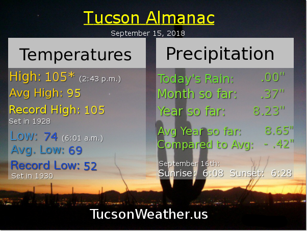
Wow! What a day yesterday!!! Record rainfall at the airport. .76″. If that’s it for Monsoon 2018 (and it probably is) what a way to say goodbye! A steady rain for HOURS yesterday afternoon and last night. Most picking up .75″ to over an inch of rain, and yes, there were some who picked up over 2 inches! Good job. The Flash Flood Watch jinx is no more.

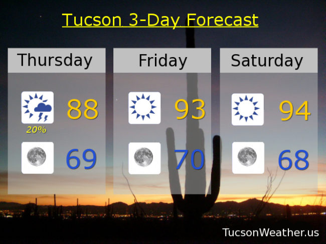
A trough moving through the state will scrub us clean of any moisture. Perhaps enough lingering for a slight chance of a storm today, but I doubt it. We’ll warm back up again, but those lows. Back to feeling a little like Fall on the patio/deck for morning coffee.

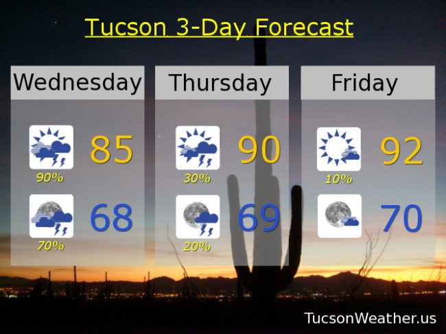
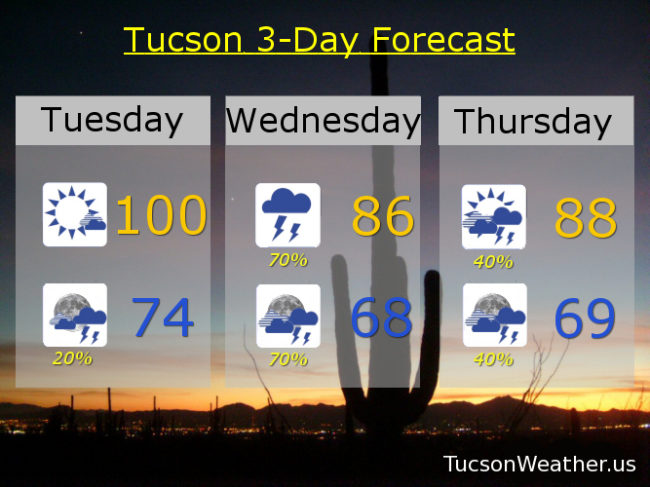
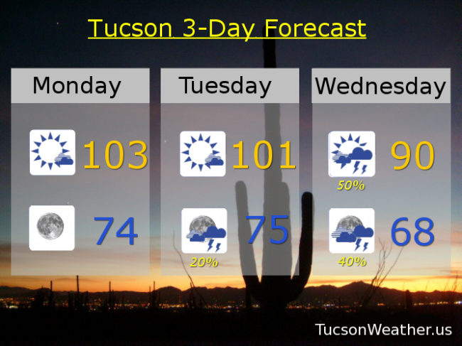
Slight chance of a storm today upper 80s to near 90. Sunny tomorrow low 90s. Mid 90s Saturday through Wednesday. Lows in the upper 60s to near 70! Enjoy!

Forecast for Wednesday, September 19, 2018

A record amount of moisture for a September 19th in place. Add some energy as a trough approacheth from the west and you have a recipe for numerous showers and storms with locally heavy rainfall. So. The National Weather Service has issued a FLASH FLOOD WATCH starting at 11:00 this morning in effect until 11:00 tonight. The forecast calls for .75″ – 2.50″ of rain! Hopefully that comes true (hopefully near you) and Monsoon 2018 will leave us with lasting memories. With the clouds and expected rain today’s forecast high is only 85. Showers and storms may last into the overnight hours with a low tonight in the upper 60s. Viva Monsoon 2018!

We get back to a westerly flow starting tomorrow and we start a drying trend. Scattered storms still hanging in there for tomorrow with a high near 90ish. Just a 10% chance Friday low 90s. Sunny mid 90s Saturday through Tuesday.

Forecast for Tuesday, September 18, 2018

104 yesterday was just 1 from the record of 105. Missed it by that much. Yikes! One more 100 degree day today before a dramatic reversal of fortunes. Moisture already on the increase with high pressure to our east and a trough to our west. That has Arizona smack dab in the middle of a southerly flow. Deep moisture headed our way with a chance for storms today mainly to our south and east possible moving into the Metro this evening. Today’s high near 100ish and tonight’s low in the mid 70s.

Tomorrow looks like prime time for showers and storms with heavy rain possible. Near record levels of moisture in here along with an inverted trough moving northward from Baja California. The result should be widespread heavy rainfall across the area with some areas getting two inches of rain or more! The National Weather Service is likely going to issue a Flash Flood Watch, so we’ll probably test the Flash Flood Watch jinx! Hopefully everything will come to pass as forecast. With the clouds and rain around, tomorrow’s high only in the mid 80s!

Moisture hangs around Thursday with a 40% chance for scattered storms and a high in the upper 80s. Some drying Friday, but still a 30% chance for storms and a high in the low 90s. 10% Chance Saturday mid 90s. Sunny Sunday and Monday upper 90s. Viva Monsoon 2018!

Forecast for Monday, September 17, 2018

We did manage a shower or two near the mountains yesterday as advertised, but most of us stayed dry. The early Fall Summer swelter continues today and tomorrow before Monsoon 2018 comes rushing back into our arms. 103 this afternoon with perhaps a mountain storm or two. Moisture on the increase as our high shifts to the east. Mostly sunny 101 tomorrow afternoon with a chance for storms by evening.

Moisture surge in full force Wednesday enhanced by tropical moisture from activity off the Mexican coast. Soupy air and instability should lead to a good chance for showers and storms near you! 50% Wednesday with a high near 90ish. 40% Wednesday night with a low in the upper 60s!

Storm chances continue into Thursday with a 40% chance for storms and a high in the upper 80s! 30% Friday near 90. 20% Saturday low 90s. Mostly sunny Sunday mid 90s. Stay tuned!

Forecast for Sunday, September 16, 2018

Hope springs eternal! Looks like Monsoon 2018 isn’t quite done with us yet. A surprise light rain shower on the deck last night, well, surprised me. Moisture has increased over the area today thanx to thunderstorm activity in Mexico pushing moisture northward. Just enough hanging around for a slight chance of a storm this afternoon with the best chance near the mountains. Only 10% but you’re saying there’s a chance! A little “cooler” today with a high near 100ish.

Sunny tomorrow with a high near 102.

Then. High pressure moves to our east allowing a southerly flow to bring back the deep, rich, scattered thunderstorm giving moisture. Tropical activity off the coast of Mexico will likely add an extra moisture push! Slight storm chances Tuesday and Tuesday night with a high near 100. Prime time for storms is Wednesday/Wednesday night with a 40% chance and a high in the low 90s! 30% chance Thursday near 90. 20% Friday near 90. 20% Saturday low 90s. Viva Monsoon 2018!