Category Archives: Daily Forecast

Forecast for Saturday, September 23, 2017

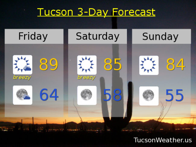
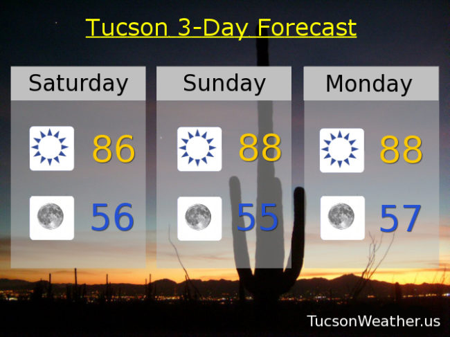
What a great start to a great weekend! Refreshingly cool this morning in the 60s as cooler air is moving in. Lows in the 50s the next 3 mornings with highs in the mid to upper 80s. Our next potential weather maker may bring us some showers and storms Wednesday into Thursday as a low forms perhaps as far south as Yuma and moves across the state. We’ll keep you posted. Enjoy!

Sunny today with a WSW breeze 5-15 mph and a high near 86.

Clear skies tonight with a low in the mid 50s.

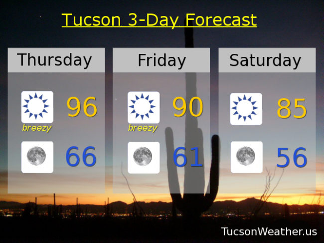
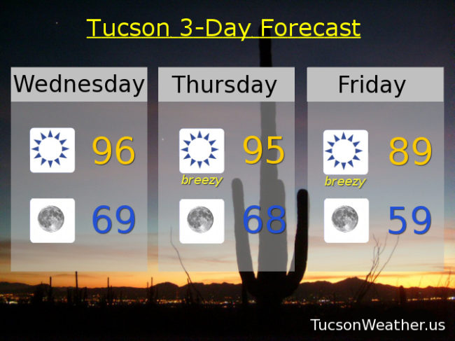
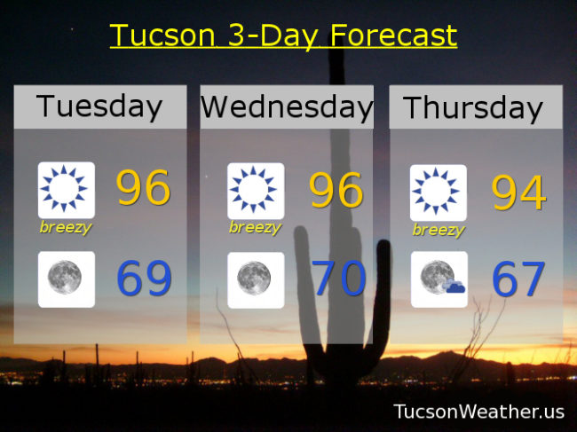
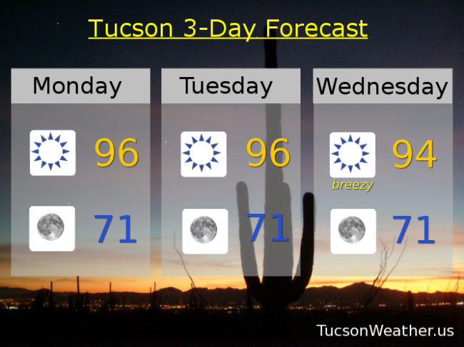
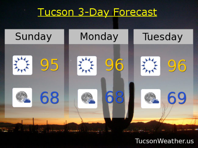
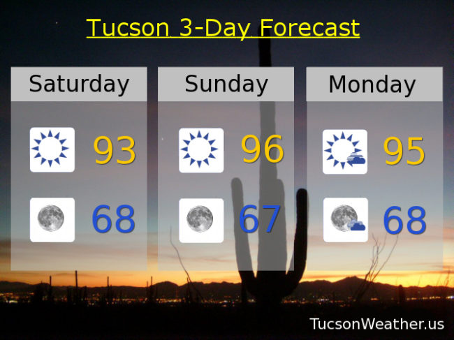
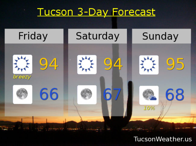
Sunny tomorrow and Monday near 88. Tuesday near 90. A 30% chance for storms Wednesday near 90. A 10% chance for storms Thursday near 90. Breezy Friday low 90s.

Forecast for Friday, September 22, 2017

Reliving the 80s! It seems so long ago. Gusty winds today and tomorrow ushering in the cooler air, and the hits keep coming! Lows in the 50s to start the day Sunday through Tuesday! Meteorologically speaking the Fall months are September, October and November, so Fall has already been with us. The Autumnal Equinox is at 1:02 this afternoon Tucson time, so astronomically speaking, Fall is arriving. No matter how you slice it, Summer is out and Fallish weather is joining the party! I for one welcome our new cooler days and refreshingly cool, even chilly (mmm chili), morning overlords! Looking beyond next week, we may warm back up in time to start October, so there may be that.

Becoming mostly sunny today and breezy with SSE winds becoming SW 10-20 mph gusting to 30 and a high in the upper 80s to near 90.

Partly cloudy tonight with WSW winds 5-15 mph and a low in the mid 60s.

Sunny and breezy tomorrow with SW winds 10-15 mph gusting to 25 and a high near 85.

Upper 50s to start Sunday with a high in the mid 80s. Mid 50s to start the day Monday and Tuesday with highs mid 80s to near 90 respectively. Near 90 Wednesday and Thursday as well. Enjoy!

Forecast for Thursday, September 21, 2017

A deepening storm system in the Intermountain West will be close enough to kick up the winds today followed by our advertised cool down. Today will be the breeziest with tomorrow kinda breezy. Mid 80s Sunday and Monday morning’s will be amazing! and somewhat chilly (mmm chili). Another low next week will keep us cooler than average for this time of year, but continued dry. Enjoy!

Sunny and breezy today with SE winds becoming SSW 15-25 mph gusting over 30 and a high near 96.

Clear skies tonight with winds relaxing but still 5-15 mph and gusty and a low in the mid 60s.

Kinda breezy tomorrow and cooler with SW winds 10-20 mph and a high near 90.

Sunny mid 80s Saturday and Sunday. Upper 80s Monday, Tuesday and Wednesday.

Forecast for Wednesday, September 20, 2017

Our advertised cool down looks to be on schedule and just in time for the Autumnal Equinox which is Friday afternoon at 1:02. Sunny again today with a high slightly above average (94) near 96. Clear skies tonight with a low ever so slightly above average (68) near 69. Storms passing to our north with snow in the Rockies will usher in cooler air for the weekend. SW winds 15-25 mph tomorrow with a high in the mid 90s. SW winds 10-20 mph Friday with a high near 89ish. Upper 50s to start the day Saturday! with a high in the mid 80s. Mid 50s to start the day Sunday and Monday! with highs in the mid 80s Sunday, upper 80s Monday. Near 90 Tuesday. Enjoy!!!

Forecast for Tuesday, September 19, 2017

Cooling off as the weekend approacheth. Breezy the next few days in the transition. Highs today and tomorrow just slightly above the seasonable average of 94 and lows slightly above the average of 68. Below average temperatures this weekend featuring lows in the upper 50s! Enjoy!

Sunny and breezy today with SW winds 15-20 mph gusting over 30 and a high near 96.

Clear skies tonight with a low in the upper 60s.

Sunny and breezy tomorrow with SW winds 10-20 mph gusting over 25 and a high near 96.

Sunny and breezy Thursday with SSW winds 15-25 mph gusting over 30 and a high near 94. Mostly sunny Friday 88. Mid 80s Saturday and Sunday. Upper 80s Monday.

Forecast for Monday, September 18, 2017

Refreshingly cool this morning! Get ready for chilly mornings (mmm chili) by this weekend as storms to our north drive a cold front our two through the area.

Seasonably warm today and tomorrow with highs in the mid 90s and lows in the low 70s.

Breezy Wednesday with SSW winds 15-20 mph gusting to 30 and a high near 94.

Breezy Thursday with a 10% chance of a storm near you and a high near 91. A 10% chance of a storm or two Friday with a high in the upper 80s. Near 60 to start the day Saturday with a high in the mid 80s. Upper 50s Sunday morning! with a high in the mid 80s. Enjoy!

Forecast for Saturday, September 16, 2017

Refreshingly cool this morning! A trough over the west will keep us near or just below seasonal highs and lows as Fall feels a just a little bit more like Fall. Slight chance of a storm or two near you early next week, but I wouldn’t count on it. Enjoy!

Sunny today with a high in the low 90s.

Clear skies tonight with a low in the upper 60s.

Sunny mid 90s tomorrow and Monday. A 10% chance for a storm Tuesday and Wednesday low 90s. Sunny low 90s Thursday. Near 90 Friday.

Forecast for Friday, September 15, 2017

Systems to our north giving us breezy conditions once again today although maybe not quite as breezy as yesterday. Cooler air moving in with lows in the mid to upper 60s the next few mornings! Refreshingly cool. Cooler highs too. Moisture tries to increase next week with a slight chance for a storm or two, hopefully near you.

Sunny and breezy today with a high near 94 with SW winds 10-20 mph gusting over 25.

Winds relax tonight with a low by tomorrow morning in the mid 60s.

Sunny tomorrow and Saturday with highs in the mid 90s. A 10% chance for storms Monday 94ish. A 20% chance for storms Tuesday low 90s. Sunny low 90s Wednesday. Near 90 Thursday.

Forecast for Thursday, September 14, 2017

The winds of change and a taste of Fall blowing in with a cool front. A couple of systems to our north will bring snow to the northern Rockies. We’ll get some cooler air with refreshingly cool mornings coming up in the upper 60s! Some moisture returns starting Sunday for slight storm chances into next week.

Sunny today becoming breezy this afternoon with SW winds 15-25 mph gusting over 30 and a high in the mid 90s.

Breezy tonight with winds relaxing after midnight. SW winds 5-15 mph gusting over 25 and a low in the low 70s.

Breezy Friday with SW winds 10-20 mph gusting over 25 and a high in the low 90s. Upper 60s to start the day Saturday with highs in the mid 90s. Upper 60s to start the day Sunday with a 10% chance of an afternoon storm and a high in the mid 90s. A 20% chance for afternoon and evening storms Monday, Tuesday and Wednesday with highs near 95, 94 and 92. Enjoy!