Category Archives: Daily Forecast

Forecast for Monday, May 1, 2017

An AMAZING day yesterday! Not too bad today and if you like it a little warmer. If so you’ll like the reminder we are getting this week that we are now in May. Can June be far behind? High pressure building in for nuthin’ but Sun and a warming trend. Still looks like near 100 for Friday. Breezy and cooler to start the weekend. Stay tuned!

Sunny today with a high near 90.

Clear tonight with a low near 60.

Sunny tomorrow low 90s. Mid 90s Wednesday and Thursday. Near 100 Friday. Breezy Saturday mid 90s. Breezy Sunday near 90.

Forecast for Sunday, April 30, 2017

Let the warming trend begin!  The system that brought snow to New Mexico, Texas, Colorado and other places that aren’t here has moved off to the east.  The wind is done!   Mostly.  High pressure building in and we could see our first 100 degree day by Cinco de Mayo.  Margaritas all around!  Cheers!

Sunny today with a NW breeze 5-15 mph and a high in the low 80s.

Clear skies tonight with a low near 50.

Sunny tomorrow near 90.  Low 90s Tuesday.  Mid 90s Wednesday & Thursday.  Near 100 Friday.  Upper 90s Saturday.

Forecast for Saturday, April 29, 2017

What a beautiful weekend!  Yes, a bit breezy today with one last RED FLAG WARNING in effect from 11:00 this morning until 8:00 tonight.  Be extra careful if you are setting stuff on fire today or shooting exploding targets.  Otherwise, if you are like me and don’t mind the wind (all those years in eastern New Mexico and west Texas I guess), 78 is about perfect!  Kinda chilly tomorrow morning (mmm chili) but another beautiful day with a high in the mid 80s.  Amazing!  Then we turn up the heat.  A steady climb of temperatures through the work week with a high near 100 by Cinco de Mayo.  Enjoy!

Sunny and breezy today with NW winds 10-20 mph with gusts around 25 and a high in the upper 70s.

Winds relaxing overnight tonight with a low by Sunday morning in the upper 40s.

Sunny tomorrow mid 80s.  Near 90 Monday.  Low 90s Tuesday.  Mid 90s Wednesday.  Upper 90s Thursday.  Near 100 Friday.

Forecast for Friday, April 28, 2017

It’s Friiiiiidaaaaay!!!  And a good day to be a kite.  A storm moving into the Four Corners and strengthening will crank up the winds once again.  A RED FLAG WARNING and a WIND ADVISORY have been hoisted for this afternoon and evening, so be advised, it’s gonna be windy.  Cooler especially tomorrow as the storm moves east.  12 degrees below average Saturday and a few degrees below average on Sunday!  Awesomeness!  If you love the heat, don’t worry.  the cool down will be short-lived.  A warming trend starts with the new week with our first 100 degree day possible on Cinco de Mayo.

Windy today with WSW winds 20-30 mph gusting to near 40 and a high in the mid 80s.

Breezy tonight with W winds 15-25 mph gusting to near 35 then relaxing to 5-15 mph after midnight and a low in the mid 50s.

Breezy and cooler tomorrow with NW winds 10-20 mph gusting over 25 and a high in the mid 70s.

Sunny low 80s Sunday.  Near 90 Monday.  Low 90s Tuesday and Wednesday.  Upper 90s Thursday.

Forecast for Thursday, April 27, 2017

Here comes the wind again.  Bad news for the Sawmill Fire.  Prayers for the firefighters that are now here from around the country to fight it.  RED FLAG WARNINGS are up for today and tomorrow.  Please for the love of all that is right and good, if you smoke keep your butt in the car!  (or truck or SUV)  A couple of systems moving by to the north will keep us windy.  The second system will cool us off quite a bit Saturday with highs 10 degrees below average and lows in the 40s Sunday morning!  Sunday looks amazing with a high in the low 80s.  Then we start a warming trend next week.  Stay tuned!

Mostly sunny with W winds 15-25 mph gusting over 35 and a high in the low 90s.

Mostly clear and breezy tonight with WSW 10-20 mph gusting to near 30 becoming southerly and relaxing some after midnight and a low in the upper 60s.

Mostly sunny and windy tomorrow with WSW winds 20-30 gusting over 40 and a high in the mid 80s.

Sunny and breezy Saturday with NW winds 10-20 gusting to near 30 and a high in the mid 70s.  Sunny Sunday low 80s.  Near 90 Monday.  Low 90s Tuesday and Wednesday.

Forecast for Wednesday, April 26, 2017

A lot less wind today with high clouds from time to time for possible sunrise and sunset enhancement.  This morning’s sunrise was beautiful!  Still breezy today with a high near average for late April.  Hopefully the break in the wind will help fire fighters get a handle on the Sawmill Fire because the winds start to ramp up again tomorrow and really get crankin’ Friday and Saturday as a storm moves through the Great Basin.  Cooler Saturday and Sunday and then warming up again next week.  Stay tuned!

Sunny today with NW winds 5-15 mph and gusty and a high in the mid 80s.

Mostly clear skies tonight with a low near 60.

Sunny tomorrow with W winds 15-25 mph gusting over 30 and a high in the low 90s.

Sunny Friday with patchy blowing dust with W winds 15-25 mph gusting to near 40 and a high near 90.

Patchy blowing dust Saturday near 80.  Sunny Sunday mid 80s.  Near 90 Monday.  Breezy Tuesday low 90s.

Forecast for Tuesday, April 25, 2017

Appropriate for a Twofer Tuesday as we dibble dip with an advisory AND warning.  A WIND ADVISORY in effect from 11:00 this morning until 8:00 tonight so be advised, it’s going to be windy.  Also a RED FLAG WARNING in effect from 2:00 this afternoon until 8:00 this evening.  Not good news for the Sawmill Fire that is still burning to our south.  Let’s hope nothing else gets started!  A storm missing us to the north today is driving the winds up and the temperatures back down to average for this time of year.  A break between storms tomorrow with even more wind Friday and Saturday.  Looks like we are staying dry, but high clouds from time to time for possible sunrise and sunset enhancement.  Stay tuned!

Mostly sunny and windy today with west winds 20-30 mph this afternoon gusting to around 40 and a high near 85.

Mostly clear tonight with west northwest winds 20-30 mph gusting to 40 becoming southerly and relaxing to 5-15 mph overnight with a low near 55.

Mostly sunny tomorrow with northwest breezes 5-15 mph a high in the mid 80s.

Sunny Thursday with west winds 10-20 mph and gusty with a high in the low 90s.  Patchy blowing dust possible Friday with a high near 90.  Mostly sunny and breezy Saturday near 80.  Sunny Sunday low 80s.  Upper 80s Monday.

Forecast for Monday, April 24, 2017

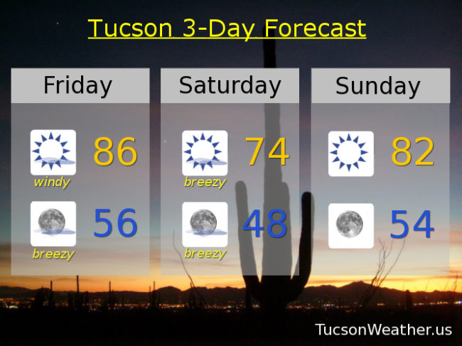
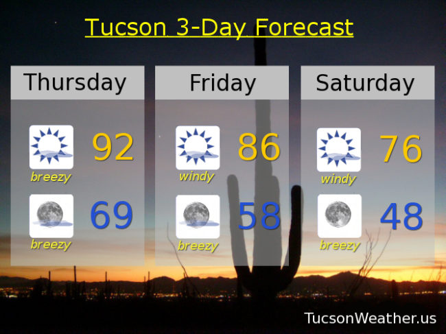
The winds of change blowing upon us this week.  High clouds from time to time too for possible sunrise and sunset enhancement!  Breezy today and tomorrow as a storm misses us to the north, but close enough to bring a slight chance of showers to the White Mountains.  Winds will be strong enough, and it’s warm and dry enough, that the National Weather Service has issued a RED FLAG WARNING from 11:00 this morning until 7:00 tonight.  I wonder if they actually hoist a red flag at the weather office?  Either way, be careful setting stuff on fire.  Please for the love of all that is right and good, if you smoke, keep your butt in the car!  Winds relax a bit on Wednesday and Thursday between systems.  Another storm approacheth by the end of the week.  This one has a chance to bring some showers to the Metro Friday night into Saturday!  Maybe.  There will be gusty winds and cooler temperatures with this storm too.  Stay tuned!

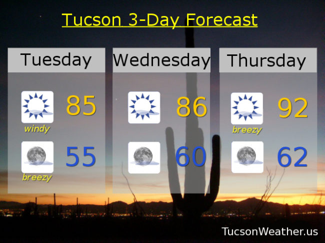
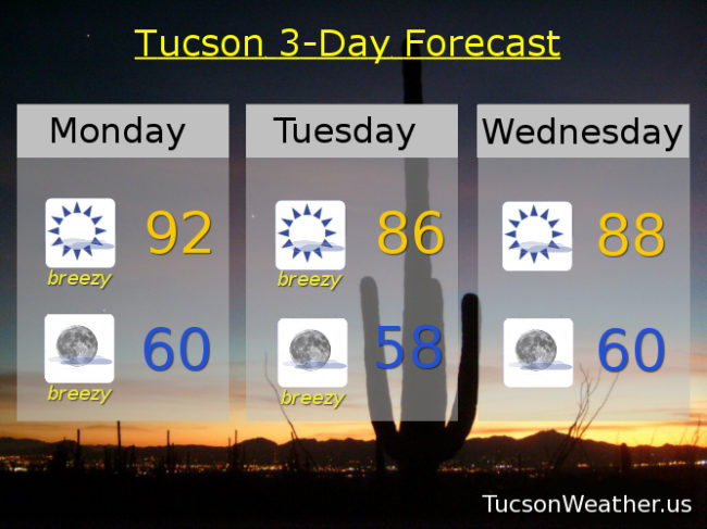
Sunny and breezy today with WSW winds 15-25 mph gusting over 30 and a high in the low 90s.

Mostly clear and breezy tonight with winding down to WSW 10-20 and a low near 60.

Sunny and breezy tomorrow with west winds gusting over 35 mph and a high in the mid 80s.

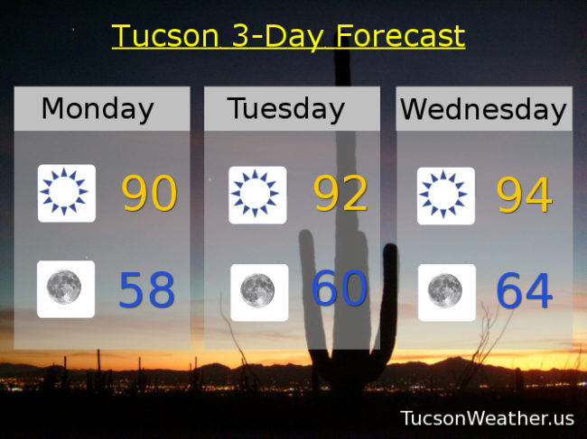
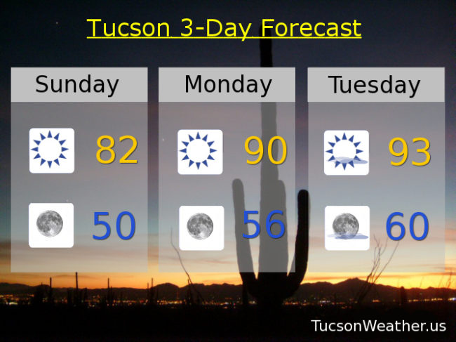
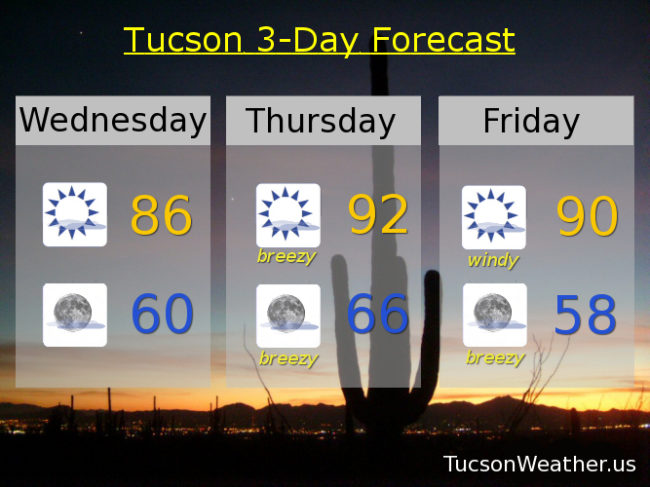
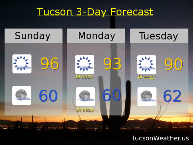
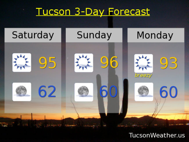
Sunny Wednesday upper 80s.  Sunny Thursday near 90.  Breezy Friday mid 80s.  Slight chance for showers Saturday and breezy upper 70s.  Sunny Sunday near 80.

Forecast for Sunday, April 23, 2017

We hit 95 for the first time this year yesterday.  A degree warmer today if the forecast comes exactly to fruition.  High clouds from time to time for possible sunrise and sunset enhancement!  Breezes for much of the upcoming week with cooling temperatures as storm after storm misses us to the north.  The Thursday/Friday system will approacheth close enough to give the White Mountains a chance for showers while we remain dry here in Tucson.  Enjoy!

Mostly sunny and a little bit breezy today with SW winds 5-15 mph and gusty and a high in the mid 90s.

Mostly clear skies tonight with a SSE breeze 5-15 mph and a low near 60.

Mostly sunny and breezy tomorrow with a FIRE WEATHER WATCH in effect from 11:00 a.m. until 7:00 p.m., so get ready to watch some fires.  Just try not to be the one who starts it!  WSW winds gusting over 30 mph and a high in the low 90s.

Mostly sunny and breezy Tuesday with a high near 90.  Sunny Wednesday near 90.  Breezy Thursday upper 80s.  Breezy Friday mid 80s.  Sunny Saturday upper 70s.


Forecast for Saturday, April 22, 2017

We turn up the heat a bit this weekend, but nothing we Tucsonans can’t handle.  Mid 90s with tons of Sun and possibly a few high clouds for sunrise and sunset enhancement.  Possibly.  The weather pattern starts to change with the new work week.  Storms to our north kicking up the breezes and actually bringing in more high clouds for sunrise and sunset enhancement!  Temperatures falling through the week as well.  Maybe even below average by Friday!  It’s OK to be below average.  Don’t ask me how I know that 🙂  Enjoy!

Sunny mid 90s today with a SE breeze just 5-10 mph.

Clear skies tonight with a low in the low 60s.

Sunny tomorrow mid 90s.  Breezy Monday with WSW winds gusting to 30 mph low 90s.  Breezy Tuesday and Wednesday near 90.  Breezy Thursday mid 80s.  Breezy Friday low 80s.