Category Archives: Daily Forecast

Forecast for Thursday, May 11, 2017

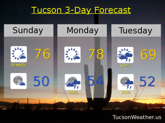
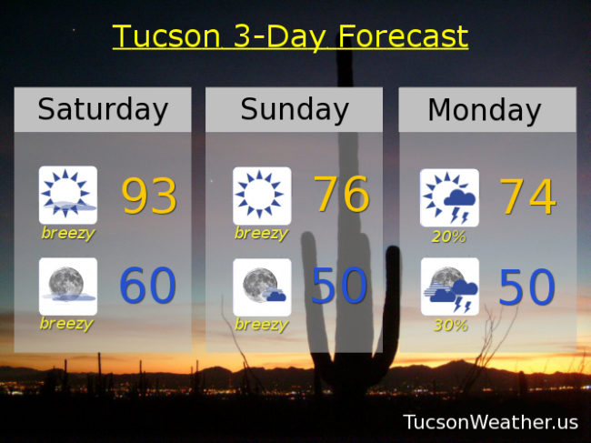
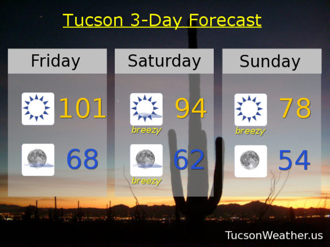
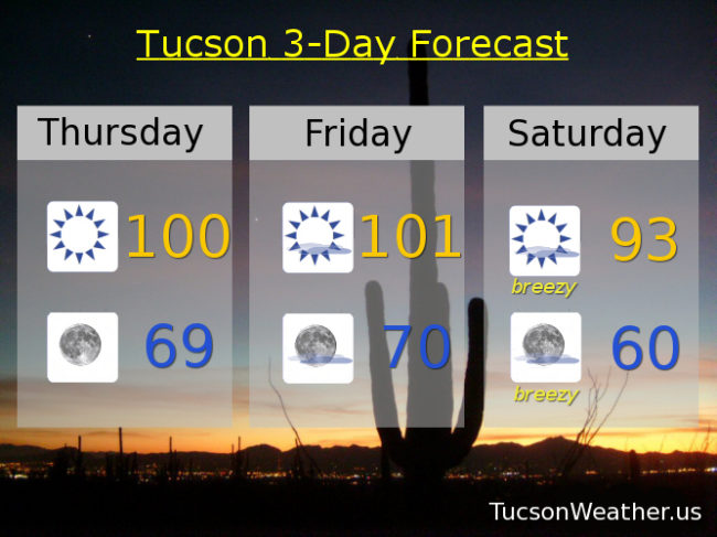
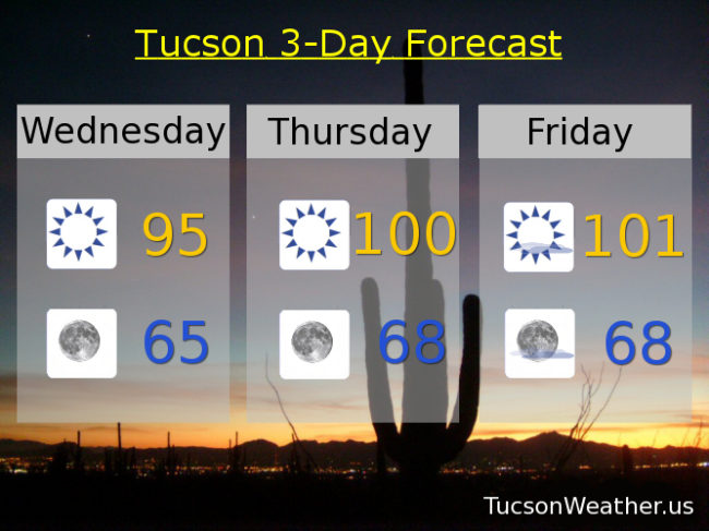
Lovers of the heat rejoice for your time is at hand!  Suns out, buns out, as the smell of coconut returns to area pools.  Lizards and snakes will find their favorite rock upon which to bake.  But alas, a storm system missing us to the north on Sunday will kick up the breezes once again.  Temperatures will drop, but not too much.  Double alas!  Another storm missing us to the north by mid week will kick up the winds again and keep our temperatures from returning to the 90s.  Stay tuned.

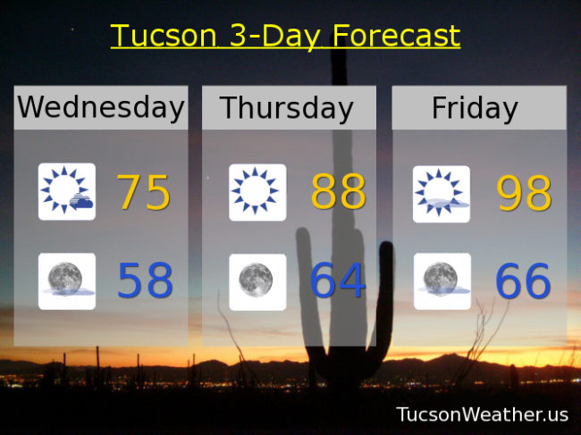
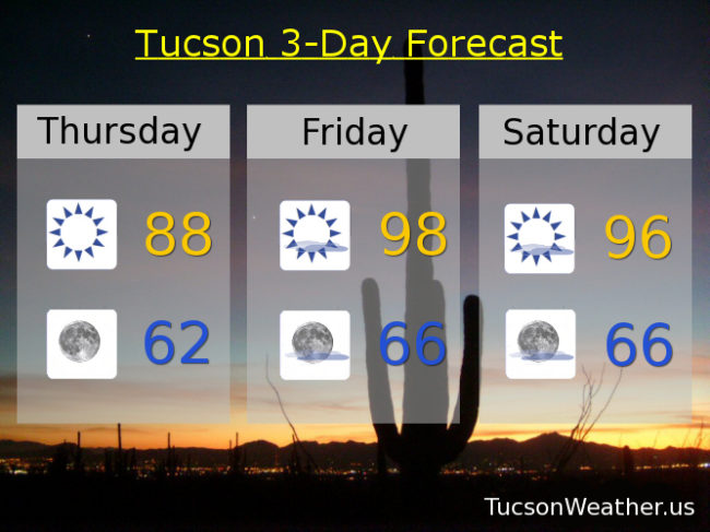
Sunny today with a high near 88.

Clear skies tonight with a low in the low 60s.

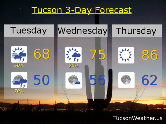
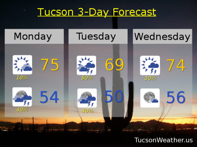
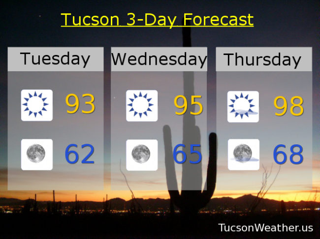
Sunny tomorrow upper 90s.  Mid 90s Saturday.  Breezy Sunday low 90s.  Breezy Monday upper 80s.  Mid 80s Tuesday.  Breezy upper 80s Wednesday.

Forecast for Wednesday, May 10, 2017

68 yesterday with showers and some snow in the mountains.  Crazy awesome for May!  Don’t get used to it.  The storm is leaving us this morning and then, “let the warming trend begin!”  Upper 90s by Friday.  A storm misses us to the north Sunday for some breezes and slightly cooler weather, but it’ll still be warm.  Here you go:

Mostly sunny today with a high near 75.

Mostly clear tonight with a low in the upper 50s.

Sunny 88 tomorrow.  Upper 90s Friday and Saturday.  Breezy Sunday mid 90s.  Near 90 Monday.  Low 90s Tuesday.

Forecast for Tuesday, May 9, 2017

RAIN!  At least a little bit for most.  Some a bit more than that.  Nice and cool today with an increasing chance of showers as an upper low slowly moves our way from the Gulf of California.  The mountains are getting a bit more snow than expected above 7,000 and some valley locations could pick up a half inch of rain today.  Hopefully near you!  Some of the stronger storms this afternoon could even have small hail.  Today’s high is only expected in the upper 60s.  The National Weather Service says that the last time a May day didn’t get out of the 60s was 2009.  A rare cool May day indeed!  The storm heads into New Mexico by tomorrow with a slight chance of a shower or storm on the backside.  Then a warming trend the rest of the week.  Another storm misses us to the north Sunday and Monday for breezy conditions and a bit of a cool off.  Something for everyone!  Enjoy!

Mostly cloudy today with scattered showers and storms, especially this afternoon and evening, with a high in the upper 60s.

Mostly cloudy tonight with a good chance for showers early and then decreasing overnight with a low near 50.

A chance for a lingering shower or storm tomorrow otherwise mostly sunny with a high in the mid 70s.

Sunny mid 80s Thursday.  Mid 90s Friday.  Upper 90s Saturday.  Breezy low 90s Sunday.  Breezy upper 80s Monday.

Forecast for Monday, May 8, 2017

Here we go!  A strong and unusually cold storm system for this time of year is on our doorstep.  Actually it’s centered in Baja California and will be turning the corner and heading our way by tonight.  Increasing chance for showers and thunderstorms as the system approacheth and moves through.  Valley rain up to a quarter inch for most with some folks getting more.  Hopefully near you!  Still looking at 1-4 inches of snow above 7,000 feet.  The storm exits stage east by Wednesday with a warming trend on its heals.  Enjoy!

Partly cloudy today with a slight chance for a storm.  S wind 5-15 mph and gusty with a high in the mid 70s.

Mostly cloudy tonight with a chance for showers and storms and a low in the mid 50s.

Partly sunny tomorrow with scattered showers and storms and a high near 70 maybe.

Lingering shower chances Wednesday morning with a high in the mid 70s.  Sunny Thursday 85.  Low 90s Friday.  Mid 90s Saturday.  Breezy low 90s Sunday.

Forecast for Sunday, May 7, 2017

MUCH cooler today with a cooling trend continuing through Tuesday as a strong low pressure system approacheth.  Breezy again today but not quite as windy as yesterday.  As the storm moves through on Tuesday look for a good chance of showers and thunderstorms with most valley locations expecting a quarter inch or less of rain, but some folks could see more with heavier downpours.  Hopefully near you!  The mountains could even get 1-4 inches of snow above 7,000 feet!  Then a warming trend with low to mid 90s by the end of the week.  Stay tuned!

Mostly sunny and breezy today.  SSW winds 15-25 mph gusting over 30.  A stray shower is possible but the chances are low.  Today’s high in the mid 70s.

Partly cloudy tonight with winds relaxing and a low near 50.

Mostly sunny tomorrow with a SSW wind 10-20 mph and a high in the upper 70s.

Showers and thunderstorms possible on Tuesday with a high in the upper 60s!

Slight chance of lingering showers Wednesday mid 70s.  Sunny Thursday mid 80s.  Low 90s Friday.  Mid 90s Saturday.

Forecast for Saturday, May 6, 2017

We hit 104 yesterday to break the record of 102 set in 1947.  A storm approacheth as we are set to flip the weather script.  MUCH cooler with a chance for showers and thunderstorms by Monday and especially Tuesday.  Windy today and tomorrow in the transition.  So much so that the National Weather Service has issued a WIND ADVISORY, so be advised, it’s going to be windy and a RED FLAG WARNING.  Both are in effect from 10:00 this morning until 7:00 tonight.  Please, for the love of all that is right and good, if you smoke keep your butt in the car.  Also be careful setting stuff on fire or shooting exploding targets in the desert.  The storm moves through Tuesday with our best chance for storms.  Temperatures swinging from 16 degrees above average yesterday to 16 degrees below average Tuesday.  A warming trend starts mid next week.  Enjoy!

Mostly sunny and breezy today with S winds 20-25 mph gusting over 35 and a high in the low 90s.

Mostly clear tonight and breezy with S winds 15-20 mph relaxing after midnight and a low near 60.

Sunny and breezy tomorrow with S winds 15-25 mph gusting to near 35 and a high in the mid 70s.  A slight chance for showers and storms Monday with a high in the mid 70s.  Scattered showers and storms Tuesday low 70s.  Mostly sunny Wednesday upper 70s.  Upper 80s Thursday.  Low 90s Friday.

Forecast for Friday, May 5, 2017

Cinco de Mayo on a Friiiiiidaaaaay!  That is pretty good planning.  Another hot day before a dramatic change in the weather pattern cools us off and brings a chance for showers and thunderstorms by Tuesday of next week.  We hit 100 for the first time this year yesterday afternoon at 2:34.  Today should be at least as hot with an expected high of 101.  Then a strong storm approacheth which will kick up the winds and drive a cold front through southern Arizona.  It will be much cooler.  That’s what cold fronts do.  A FIRE WEATHER WATCH is in effect tomorrow so be careful setting stuff on fire.  As the storm moves through early next week we could see showers and storms.  That would be nice.  Hopefully one or two near you.  Stay tuned!

Sunny today with a high near 101.

Mostly clear skies tonight with a low in the upper 60s.

Mostly sunny and breezy tomorrow with SSW winds 20-25 mph gusting around 35 and a high in the mid 90s.

Sunny breezy and cooler Sunday with SW winds 15-25 mph gusting over 30 and a high in the upper 70s.

Mostly sunny with a slight chance of rain Monday and a high in the low 70s.  Scattered showers and storms Tuesday mid 70s.  Slight chance of showers Wednesday low 80s.  Sunny upper 80s Thursday.

Forecast for Thursday, May 4, 2017

It’s a little early, but it looks like today will be our first 100 degree day of the year.  If we manage to fall just short we’ll hit it tomorrow.  Don’t get used to it.  A strong storm approacheth for increasing wind and decreasing temperatures this weekend and a chance for showers and storms by Tuesday.  Stay tuned!

Sunny and hot today with a high near 100.

Clear skies tonight with a low in the upper 60s to near 70.

Sunny and hotter tomorrow with a high near 101.  Breezy and cooler Saturday with a high in the low 90s.  Breezy Sunday low 80s.  Breezy Monday mid 70s.  Scattered showers and thunderstorms possible Tuesday mid 70s.  Mostly sunny Wednesday low 80s.

Forecast for Wednesday, May 3, 2017

Hot until it’s not.  High pressure building in with our first 100 degree day of the year likely tomorrow or Friday.  Then a strong storm system approacheth with wind, cooling temperatures and maybe some showers early next week.  Stay tuned!

Sunny today with a high in the mid 90s.

Clear skies tonight with a low in the mid 60s.

Sunny tomorrow and Friday near 100.  Breezy Saturday mid 90s.  Breezy Sunday low 80s.  Breezy Monday upper 70s.  Slight chance of storms Tuesday upper 70s.

Forecast for Tuesday, May 2, 2017

Our old pal high pressure bringing nuthin’ but Sun and increasing heat as we cruise through the week.  Spring breezes return this weekend as a strong storm approacheth.  A chance for showers or a storm as the system moves through Monday and Tuesday?  Stay tuned!

Sunny today with a high in the low 90s.

Clear skies tonight with a low in the low 60s.

Sunny mid 90s tomorrow.  Upper 90s Thursday.  Near 100 Friday.  Breezy Saturday upper 90s.  Breezy Sunday upper 80s.  Breezy Monday with a slight chance of a shower or storm near 80.